Thursday, 5 December 2013
Marine application
3D model (MIKE 3 FMHD with MIKE 3 FMPT)
Two simultaneous releases both made at 3.0m below the water surface. The square markers are the neutrally buoyant particles (e.g. bacteriological effluent), and these are permanently deposited (i.e. not re-suspended) upon contact with the bed. The triangular markers are negatively buoyant particles that have a positive fall velocity (e.g. sand), these are allowed to re-suspend upon contact with the bed. The reduced flow speeds near the bed (from the 3D model) can be clearly seen by the movement of the sand particles. Marker colour changes to represent the vertical position of the particle.
Riverine application
2D model (MIKE 21 FMHD with MIKE 21 FMPT)
Neutrally buoyant particles released at bed level in a river with a varying flow. The trails show the previous location of the particles (for the last 3 time steps).
MIKE to Google Earth Datum Shift
 Google Earth is using the ellipsoid WGS84 to define geo-positions on the earth. If the dfs2 file uses a projection that is based on another ellipsoid the area may not be displayed correctly compared to the satellite images. In this case it may be necessary to apply Datum shift in addition to the automatic coordinate transformation in order for the image to be located correctly.
Here you can specify the parameters needed to transfer the data from the defined map projection into the domain used by Google Earth.
You can read more about Datum Conversion in the Geodesy manual supplied with the installation (MIKE_Zero_Geodesy.pdf).
See also: http://www.arcwebservices.com/arcwebonline/services/dattrans.htm
For example: -
1195 OSGB_1936_To_WGS_1984_1
GEOGTRAN["OSGB_1936_To_WGS_1984_1",GEOGCS["GCS_OSGB_1936",DATUM["D_OSGB_1936",SPHEROID["Airy_1830",6377563.396,299.3249646]],PRIMEM["Greenwich",0.0],UNIT["Degree",0.0174532925199433]],GEOGCS["GCS_WGS_1984",DATUM["D_WGS_1984",SPHEROID["WGS_1984",6378137.0,298.257223563]],PRIMEM["Greenwich",0.0],UNIT["Degree",0.0174532925199433]],METHOD["Geocentric_Translation"],PARAMETER["X_Axis_Translation",375.0],PARAMETER["Y_Axis_Translation",-111.0],PARAMETER["Z_Axis_Translation",431.0]]
Monday, 2 December 2013
Previews of MIKE by DHI Release 2014
Approximately once a year, we release a new version of our MIKE by DHI software - and this year is no exception. We would like to reveal herewith a preview of some of the new and exciting features to be released in December. We hope these new features will improve your experience with our software products, regarding usability, productivity as well as enhanced applications.
New possibilities of including moving objects in your animations
Ever wanted to add moving objects to your animations? This is possible with Release 2014.
In the September issue of this newsletter, we included a preview of new features in MIKE Animator Plus in Release 2014. In this issue, we would like to show you an example of the possibilities of this new development.
With MIKE Animator Plus, you can create visual animations to present you model results – and as something new, you will be able to include visualisation of solids. Through the inclusion of solids, you can improve your animations significantly by enhancing realism and recognition of locations, for example by including fixed elements like buildings and dams or moving elements like ships. Release 2014 will support the placement of solids inside the model domain and allow them to move, which means that a ship can be sailing as part of the animation.
MIKE HYDRO Basin: Global prioritisation of water users
 MIKE HYDRO Basin is our new generation of integrated river basin analysis software for water resources planning and management.
MIKE HYDRO Basin was introduced with the current release 2012, containing a large number of features relevant for integrated river basin management applications. Developments continue for MIKE HYDRO Basin and the new release will introduce another very interesting new feature to modellers of river basin water allocation schemes and resources management; Global Prioritisation.
With this new feature, it is now possible to include a user defined prioritisation of water users within the basin model - regardless of their geographical location within the basin. Thus, it highly increases the applicability of MIKE HYDRO Basin for specific types of water resources management applications.
The global prioritisation of water users are defined through ‘Ranking’ number definitions, where water consumers are assigned an individual ranking number. The ranking numbers are used during simulation to prioritise consumers, in case of water shortage, in order to accommodate the water demands for these - taking into account that some users have a higher priority than others.
Mesh Generation: A new tool for creating flexible meshes from dfs2 files and other sources
 The combination of high flexibility of flexible meshes (FM) and impressive performance improvements, introduced in the latest releases of MIKE by DHI, make the use of FM versions of MIKE 21, MIKE 3 and MIKE FLOOD even more attractive. Improvements in recent releases include, amongst others, the introduction of shared memory based parallelisation, porting of simulation engines to LINUX and, in Release 2014, supporting Graphical Processing Units (GPUs) for MIKE 21 HD FM.
In order to assist those, who want to transfer existing models or bathymetries into the FM system, Release 2014 will contain a new tool, aimed to convert bathymetries in other formats into FM format.
The new Mesh Converter is included in the MIKE Zero Toolbox and supports DHI’s own format from the ‘classic’ modelling series, dfs2 as well as some external formats (ADCIRC, SMS, TUFLOW). The process is quick and easy and produces an equal bathymetry in FM format, which can then be modified using all the existing editing facilities of MIKE Zero’s Mesh Generator.
New features in FEFLOW 6.2
 FEFLOW 6.2 offers a number of new features to enhance your groundwater modelling work.
Storage Capture/Release is a new component in the Rate Budget and Period Budget Panels for flow and transport in FEFLOW 6.2. With this new component, you can clearly separate storage change and solution error in transient models.
Increased performance with new MIKE 1D features in MIKE URBAN
Strengthening wastewater modelling projects with new features in WEST 2014
We are also pleased to inform you that Release 2014 of WEST will include a plant wide model (PWM) for simulating nutrient removal activated sludge systems.
The plant wide model is developed jointly by our WEST Development Centres, the Universities of Cape Town (UCT) and kwaZulu-Natal in South Africa.
Approximately once a year, we release a new version of our MIKE by DHI software - and this year is no exception. We would like to reveal herewith a preview of some of the new and exciting features to be released in December. We hope these new features will improve your experience with our software products, regarding usability, productivity as well as enhanced applications.
New possibilities of including moving objects in your animations
Ever wanted to add moving objects to your animations? This is possible with Release 2014.
 |
| Click here to view an example of the possibilities of this new feature. |
With MIKE Animator Plus, you can create visual animations to present you model results – and as something new, you will be able to include visualisation of solids. Through the inclusion of solids, you can improve your animations significantly by enhancing realism and recognition of locations, for example by including fixed elements like buildings and dams or moving elements like ships. Release 2014 will support the placement of solids inside the model domain and allow them to move, which means that a ship can be sailing as part of the animation.
MIKE HYDRO Basin: Global prioritisation of water users
MIKE HYDRO Basin was introduced with the current release 2012, containing a large number of features relevant for integrated river basin management applications. Developments continue for MIKE HYDRO Basin and the new release will introduce another very interesting new feature to modellers of river basin water allocation schemes and resources management; Global Prioritisation.
With this new feature, it is now possible to include a user defined prioritisation of water users within the basin model - regardless of their geographical location within the basin. Thus, it highly increases the applicability of MIKE HYDRO Basin for specific types of water resources management applications.
The global prioritisation of water users are defined through ‘Ranking’ number definitions, where water consumers are assigned an individual ranking number. The ranking numbers are used during simulation to prioritise consumers, in case of water shortage, in order to accommodate the water demands for these - taking into account that some users have a higher priority than others.
Mesh Generation: A new tool for creating flexible meshes from dfs2 files and other sources
In order to assist those, who want to transfer existing models or bathymetries into the FM system, Release 2014 will contain a new tool, aimed to convert bathymetries in other formats into FM format.
The new Mesh Converter is included in the MIKE Zero Toolbox and supports DHI’s own format from the ‘classic’ modelling series, dfs2 as well as some external formats (ADCIRC, SMS, TUFLOW). The process is quick and easy and produces an equal bathymetry in FM format, which can then be modified using all the existing editing facilities of MIKE Zero’s Mesh Generator.
New features in FEFLOW 6.2
Groundwater age calculation in FEFLOW 6.2
Groundwater Age is a new type of problem class, similar to mass or heat transport. With this, many questions can be easily answered, such as:
- How long is the average underground travel time of water pumped at a well?
- What‘s the percentage of bank filtration at the supply wells?
- What‘s the age and remaining travel time of groundwater at a certain location?
Storage Capture/Release is a new component in the Rate Budget and Period Budget Panels for flow and transport in FEFLOW 6.2. With this new component, you can clearly separate storage change and solution error in transient models.
Increased performance with new MIKE 1D features in MIKE URBAN
In 2012, we introduced a new generic 1D numerical engine for MIKE by DHI products. With the upcoming release of MIKE URBAN 2014, a number of new features for MIKE 1D will be available such as:
- coupling to MIKE SHE
- options for Advection-Dispersion modelling
- result presentation in MIKE URBAN
- and many more…
Strengthening wastewater modelling projects with new features in WEST 2014
Our WEST software package, for modelling wastewater treatment plants, has quickly established itself as an important product in the MIKE by DHI family with a growing number of users all over the world. Release 2014 includes several important new features, including:
- New Report Generator, which enables the user to automatically create reports containing graphs and data pertaining to a project in a variety of formats including: project information, plant layout, plots and tables.
- Integrated urban water system (IUWS) libraries, making WEST a powerful tool for identifying synergies and to globally optimise the wastewater system performance on a catchment scale.
We are also pleased to inform you that Release 2014 of WEST will include a plant wide model (PWM) for simulating nutrient removal activated sludge systems.
The plant wide model, ‘PWM_SA’, is a three phase model for the simulation of nutrient removal activated sludge systems coupled with the anaerobic (organisms independent of oxygen), aerobic (organisms dependent on oxygen) and anoxic-aerobic digestion of sewage sludge. This includes waste activated sludge produced by biological excess phosphorus removal plants. The model is based on strict material mass balance and is prepared by linking:
- a variation of ASM2 for activated sludge nitrogen and phosphorus removal and aerobic or anoxic–aerobic digestion
- a variation of the UCT anaerobic digestion model.
The plant wide model is developed jointly by our WEST Development Centres, the Universities of Cape Town (UCT) and kwaZulu-Natal in South Africa.
Screencasts FEFLOW Tutorials
FEFLOW Tutorial No. 3 - User Interface
The remaining tutorials can be accessed from our FEFLOW website here, or via our YouTube channel here. The screencasts show a number of workflows in the FEFLOW user interface. The numbers of the videos refer to chapters in the FEFLOW User Manual, where all these tutorials are described in a detailed, step-by-step way.
Screencasts FEFLOW Demonstration Exercise
FEFLOW Demo Exercise No. 1 - Working with maps
The remaining demo exercises can be accessed from our FEFLOW website here, or via our YouTube channel here. These animations refer to the Demonstration Exercise that can be downloaded from manuals page. The exercise can be repeated by using the free demo version of FEFLOW available from download page.

Development of new modelling tools for national marine water planning based on ECO Lab
Our ecological modelling software, ECO Lab, will be used in a new project with the aim to develop an advanced set of dynamic modelling tools, which will be the official tools for marine water planning in Denmark in the coming years.
The project is initiated as a collaboration between DHI and Danish Centre for Environment and Energy (DCE). The project will develop and apply ecosystem models by using our MIKE by DHI software, ECO Lab, and addressing the governing coastal processes and ecosystem services such as sediment processes, sea grass, algal growth and oxygen depletion.
For more information, click here or contact Anders Erichsen, DHI.
You can also read more about ecological modelling by clicking the links below:
- Applying ECO Lab for solving ecosystem challenges
- Modelling the behaviour of organisms with ABM Lab in response to the environment
Enabling optimised construction of the London Array offshore wind farm
Our real-time system provided accurate forecasts of Metocean conditions on a detailed spatial and temporal scale for the world’s largest wind farm – London Array. This enabled London Array Ltd. – the consortium behind the wind farm – to optimise the construction of the offshore wind farm. The result: minimised delays and ensured safety for those working on the project.
Situated in the outer Thames Estuary, is the world’s largest offshore wind farm: the 1 GW London Array. Weather conditions in this area are often challenging, which made construction and installation of the wind farm difficult. As such, high-quality and reliable Metocean data was vital for the successful planning and installation of London Array’s foundations and turbines.
London Array Ltd. needed to be able to predict available weather windows. We used our 30 years of experience in Metocean forecasting for this purpose. This ensured that the London Array project benefitted from the most up-to-date and advanced technologies, combined with local experience of forecasting techniques and equipment.
By assisting London Array Ltd. with forecasting Metocean conditions, our system helped keep delays to a minimum during the construction phase. In addition, our system also enabled London Array Ltd. to efficiently plan maintenance work during the operations phase.
Read more.
CARM wins Australia’s national Environmental Engineering Excellence Award
On 20 November 2013, the Institution of Engineers Australia awarded the Computer Aided River Management (CARM) project the Environmental Engineering Excellence Award. This prestigious award honours the top achievements in environmental engineering and the sustainable use of natural resources. The award was received by our client State Water Corporation of New South Wales.
Our software is the backbone of CARM – a Decision Support System (DSS) based on MIKE CUSTOMISED by DHI components. CARM gives State Water Corporation an insight into the current and forecasted state of the Murrumbidgee River. It utilises a suite of MIKE by DHI models to reproduce key catchment and river processes for the entire 1,600 km river system, and combines them with real-time measurements. This allows river operators to combine dam releases with natural tributary inflows to deliver the right amount of water when and where it is needed.
For more information on the CARM project, click here
Read the October 2013 Edition of the DHI Group newsletter here.
Thursday, 14 November 2013
Previews of MIKE by DHI Release 2014
Approximately once a year, we release a new version of our MIKE by DHI software - and this year is no exception. We would like to reveal herewith a preview of some of the new and exciting features to be released later this year. We hope these new features will improve your experience with our software products, regarding usability, productivity as well as enhanced applications.
MIKE Zero 2014 – beyond memory limitations
Unleash the full potential of your hardware with MIKE Zero release 2014.
 MIKE Zero is the overall graphical user interface (GUI) framework for most of the MIKE by DHI products and the coming release will introduce the entire MIKE Zero framework to our users as a true 64-bit application. This completes the transition process of MIKE Zero based products from 32-bit applications with Windows operating system limitations on memory usage to unlimited and true 64-bit applications.
It includes all MIKE Zero user interface components, toolboxes and utilities as well as our computational engines.
Memory usage is now only limited by your hardware. Common, memory demanding operations such as high resolution mesh generation, results analysis and processing are now possible without any risk of limitations from built-in limitations within your PC’s operating system. Enjoy the unlimited capabilities of MIKE Zero with Release 2014 of MIKE by DHI!
Including overtopping in MIKE 21 and MIKE 3
 In the last few years, there has been a growing focus on the phenomenon of overtopping of coastal structures like sea walls and other defence structures. This increased interest is due to more frequent loss of human life and economic losses.
In release 2014 of MIKE 21 HD and MIKE 3 HD (FM versions), we are introducing a new feature that gives you the possibility of including overtopping in your hydrodynamic simulations.
In release 2012, a new dike structure was introduced that made it possible to use this type of structures in a flexible manner. This dike structure has now been enhanced allowing you to choose either to directly specify the overtopping discharge or to have the overtopping discharge calculated by specifying a table that expresses the overflow as a function of the freeboard, wave height and period. The direct specification of overtopping can be constant or varying – both in time and along the dike.
When you choose to have the overtopping calculated, the dynamic variation of the simulation results is taken into account. We expect to introduce more developments of these aspects in upcoming versions.
Restore and recreate views in FEFLOW with the new scene library panel
The new FEFLOW 6.2 will feature a very convenient tool to store different views in your FEFLOW model or results files. Supermesh, slice, 3D and cross-section view settings can be stored in a Scene Library panel, which will allow you to easily restore or recreate views from stored scenes. The library will provide different filters and an option to create folders and lists in order to organise the stored scenes according to your preferences.
 As an additional benefit, the provided import and export functionality will facilitate the creation of a large number of identical views in different model scenarios – all with just a few mouse clicks.
With this new feature, view windows no longer need to remain open in order not to lose the chosen view settings but can be stored in the Scene Library. This will require less memory usage and CPU time.
Approximately once a year, we release a new version of our MIKE by DHI software - and this year is no exception. We would like to reveal herewith a preview of some of the new and exciting features to be released later this year. We hope these new features will improve your experience with our software products, regarding usability, productivity as well as enhanced applications.
MIKE Zero 2014 – beyond memory limitations
Unleash the full potential of your hardware with MIKE Zero release 2014.
It includes all MIKE Zero user interface components, toolboxes and utilities as well as our computational engines.
Memory usage is now only limited by your hardware. Common, memory demanding operations such as high resolution mesh generation, results analysis and processing are now possible without any risk of limitations from built-in limitations within your PC’s operating system. Enjoy the unlimited capabilities of MIKE Zero with Release 2014 of MIKE by DHI!
Including overtopping in MIKE 21 and MIKE 3
In release 2014 of MIKE 21 HD and MIKE 3 HD (FM versions), we are introducing a new feature that gives you the possibility of including overtopping in your hydrodynamic simulations.
In release 2012, a new dike structure was introduced that made it possible to use this type of structures in a flexible manner. This dike structure has now been enhanced allowing you to choose either to directly specify the overtopping discharge or to have the overtopping discharge calculated by specifying a table that expresses the overflow as a function of the freeboard, wave height and period. The direct specification of overtopping can be constant or varying – both in time and along the dike.
When you choose to have the overtopping calculated, the dynamic variation of the simulation results is taken into account. We expect to introduce more developments of these aspects in upcoming versions.
Restore and recreate views in FEFLOW with the new scene library panel
The new FEFLOW 6.2 will feature a very convenient tool to store different views in your FEFLOW model or results files. Supermesh, slice, 3D and cross-section view settings can be stored in a Scene Library panel, which will allow you to easily restore or recreate views from stored scenes. The library will provide different filters and an option to create folders and lists in order to organise the stored scenes according to your preferences.
As an additional benefit, the provided import and export functionality will facilitate the creation of a large number of identical views in different model scenarios – all with just a few mouse clicks.With this new feature, view windows no longer need to remain open in order not to lose the chosen view settings but can be stored in the Scene Library. This will require less memory usage and CPU time.
 |
| Link to ICFR 2013 Website |
Experiences in Asia and Europe
5-7 September 2013
Exeter, United Kingdom
A belated thank you to the team at the University of Exeter (David Butler, Albert Chen, Slobodan Djordjević, Michael Hammond, their colleagues and students), and their CORFU partners, for the exceptional ICFR 2013 conference held in September 2013. It was great to see so many fantastic presentations of projects featuring innovative use of MIKE by DHI software (particularly MIKE URBAN and MIKE FLOOD) and new MIKE CUSTOMISED solutions.
 |
| DHI's Ole Mark speaks at ICFR 2013 |
- Flood damage assessment for urban growth scenarios - A. S. Chen (presenter), M. J. Hammond, S. Djordjević, D. Butler
- Getting started with urban flood modelling for real-time pluvial flood forecasting - Jeanne-Rose René (presenter), Slobodan Djordjević, David Butler, Henrik Madsen, Ole Mark
The University of Exeter have also developed a CORFU Flood Damage Assessment Tool (compatible with the Multi-Coloured Manual) for MIKE 21, MIKE FLOOD and MIKE URBAN results files (i.e. dfs2 and dfsu). We hope to have more information on this tool very soon.
Tuesday, 5 November 2013
MIKE by DHI Software - A short introduction
Temperature Exchange Using MIKE FLOOD AD Links
The coupling between MIKE 11 and MIKE 21 Flow Model FM has been implemented for temperature, salinity, components in the Transport module (FMAD) and components in the ECOLAB module; so a coupled (MIKE FLOOD) model can allow for the full exchange of salinity, temperature and other tracers: -
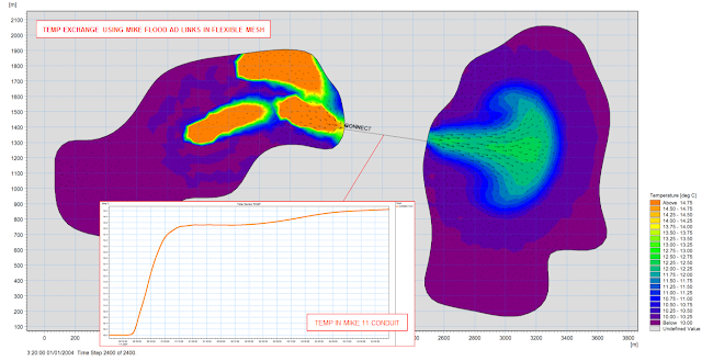
Figure: Two FM domains connect by a long culvert (MIKE 11 branch with closed cross sections), inflow far left, 3 heat sources in the upper lagoon.
Monday, 4 November 2013
Previews of MIKE by DHI Release 2014
Approximately once a year, we release a new version of our MIKE by DHI software - and this year is no exception. We would like to reveal herewith a preview of some of the new and exciting features to be released later this year. We hope these new features will improve your experience with our software products, regarding usability, productivity as well as enhanced applications.
Introducing MIKE 21 GPU
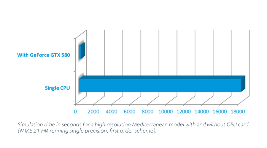
If you are using MIKE 21 FM HD or Flexible Mesh solver with MIKE FLOOD, you are getting a pleasant surprise with Release 2014! With the new release, your update package will automatically include a brand new version of the MIKE 21 FM HD module. The new version, MIKE 21 GPU (Graphical Processor Units), is “GPU-card enabled”. This means that it is able to use the graphics card on your PC to speed up simulations significantly.
 Speed up you models
Depending on the model setup and the type of GPU, the speed-up can be a factor 100 or more compared to running the same simulation on a single processor CPU.
For some model setups and GPUs, this also means that MIKE 21 FM is now faster than MIKE 21 “Classic” - the single grid version of MIKE 21 HD - when using exactly the same rectangular mesh.
The technology behind MIKE 21 GPU: How does it work?
The computational engine of MIKE 21 FM HD has been reprogrammed to make use of the latest graphical processor units - hardware that is otherwise typically used for speeding up computer games.
How will I get MIKE 21 GPU?
MIKE 21 GPU will become available, at no extra cost, to all owners of corporate licences of MIKE 21 or MIKE FLOOD with valid SMA. This means that there will be no licence fee and no increase in SMA costs. If you do not have a valid SMA or if you own a personal licence, you will be able to purchase it as an upgrade to your existing software.
Where can I read more about MIKE 21 GPU?
We have produced a detailed performance report, including comparisons of the performance of MIKE 21 GPU with the non-GPU enabled MIKE 21 FM HD. Click here to read the report.
For more information about MIKE 21 GPU, check out future issues of this new newsletter or contact our software support team.
Introducing exciting new possibilities in MIKE Animator Plus
Version 2012 of MIKE by DHI included a completely re-engineered version of MIKE Animator, designed to be a very flexible tool for producing high quality video animations of modelling results. The most prominent new features in version 2012 were the support of MIKE 3 files (including the ability to slice and take out transects and iso-surfaces) and also improved picture draping functionality.
We have continued the development of MIKE Animator Plus and version 2014 will contain three new and interesting possibilities:
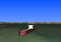 Visualisation of solids: Enhancing realism and recognition of locations
The inclusion of solids can improve the animations significantly through enhancing realism and recognition of locations, for example by including fixed elements like buildings or dams or moving elements like ships. Version 2014 will support the placement of solids inside the model domain. These elements have to be created in 3DS format and then loaded into MIKE Animator Plus. Moreover, they can move inside the animation, which means that a ship can be sailing as part of the animation.
Visualisation of particles: Enhancing result communication
Output files with particle trajectories from the Particle Tracking (PT) modules (MIKE 21 PT and MIKE 3 PT) and from the Agent Based Modelling (ABM) modules (ABM for MIKE 21 and MIKE 3) will now be supported in MIKE Animator Plus. This will enhance the possibilities for result communication from these modules significantly. Click here to view an example.
Support of MIKE SHE files: High quality animations of MIKE SHE results
Also, output from MIKE SHE will now be supported in MIKE Animator Plus in order to allow for high quality animations of MIKE SHE results. This will include animation of overland flow as well as 3D groundwater flow.
New water quality option in MIKE HYDRO Basin
MIKE HYDRO Basin is our new generation of integrated river basin analysis software for water recourses planning and management.
MIKE HYDRO Basin was initially introduced with the current release 2012 containing a large number of features relevant for integrated river basin management applications. Developments continue for MIKE HYDRO Basin and one of the new exiting features being introduced in release 2014 is the option of applying water quality simulations within your river basin management applications.
Water quality options in the basin management software package have traditionally been limited to a few hard-coded water quality formulations. However, the new release will include a major upgrade in that respect, as water quality modelling in MIKE HYDRO Basin will be using the open and very flexible ECO Lab modelling framework. This will allow you to alter existing water quality templates or create your own model templates from scratch. Therefore, the ECO Lab option will greatly enhance the options for applying tailored water quality modelling for your particular water resources management or planning project.
Approximately once a year, we release a new version of our MIKE by DHI software - and this year is no exception. We would like to reveal herewith a preview of some of the new and exciting features to be released later this year. We hope these new features will improve your experience with our software products, regarding usability, productivity as well as enhanced applications.
Introducing MIKE 21 GPU
If you are using MIKE 21 FM HD or Flexible Mesh solver with MIKE FLOOD, you are getting a pleasant surprise with Release 2014! With the new release, your update package will automatically include a brand new version of the MIKE 21 FM HD module. The new version, MIKE 21 GPU (Graphical Processor Units), is “GPU-card enabled”. This means that it is able to use the graphics card on your PC to speed up simulations significantly.
Depending on the model setup and the type of GPU, the speed-up can be a factor 100 or more compared to running the same simulation on a single processor CPU.
For some model setups and GPUs, this also means that MIKE 21 FM is now faster than MIKE 21 “Classic” - the single grid version of MIKE 21 HD - when using exactly the same rectangular mesh.
The technology behind MIKE 21 GPU: How does it work?
The computational engine of MIKE 21 FM HD has been reprogrammed to make use of the latest graphical processor units - hardware that is otherwise typically used for speeding up computer games.
How will I get MIKE 21 GPU?
MIKE 21 GPU will become available, at no extra cost, to all owners of corporate licences of MIKE 21 or MIKE FLOOD with valid SMA. This means that there will be no licence fee and no increase in SMA costs. If you do not have a valid SMA or if you own a personal licence, you will be able to purchase it as an upgrade to your existing software.
Where can I read more about MIKE 21 GPU?
We have produced a detailed performance report, including comparisons of the performance of MIKE 21 GPU with the non-GPU enabled MIKE 21 FM HD. Click here to read the report.
For more information about MIKE 21 GPU, check out future issues of this new newsletter or contact our software support team.
Introducing exciting new possibilities in MIKE Animator Plus
Version 2012 of MIKE by DHI included a completely re-engineered version of MIKE Animator, designed to be a very flexible tool for producing high quality video animations of modelling results. The most prominent new features in version 2012 were the support of MIKE 3 files (including the ability to slice and take out transects and iso-surfaces) and also improved picture draping functionality.
We have continued the development of MIKE Animator Plus and version 2014 will contain three new and interesting possibilities:
The inclusion of solids can improve the animations significantly through enhancing realism and recognition of locations, for example by including fixed elements like buildings or dams or moving elements like ships. Version 2014 will support the placement of solids inside the model domain. These elements have to be created in 3DS format and then loaded into MIKE Animator Plus. Moreover, they can move inside the animation, which means that a ship can be sailing as part of the animation.
Visualisation of particles: Enhancing result communication
Output files with particle trajectories from the Particle Tracking (PT) modules (MIKE 21 PT and MIKE 3 PT) and from the Agent Based Modelling (ABM) modules (ABM for MIKE 21 and MIKE 3) will now be supported in MIKE Animator Plus. This will enhance the possibilities for result communication from these modules significantly. Click here to view an example.
Support of MIKE SHE files: High quality animations of MIKE SHE results
Also, output from MIKE SHE will now be supported in MIKE Animator Plus in order to allow for high quality animations of MIKE SHE results. This will include animation of overland flow as well as 3D groundwater flow.
New water quality option in MIKE HYDRO Basin
MIKE HYDRO Basin is our new generation of integrated river basin analysis software for water recourses planning and management.
MIKE HYDRO Basin was initially introduced with the current release 2012 containing a large number of features relevant for integrated river basin management applications. Developments continue for MIKE HYDRO Basin and one of the new exiting features being introduced in release 2014 is the option of applying water quality simulations within your river basin management applications.
Water quality options in the basin management software package have traditionally been limited to a few hard-coded water quality formulations. However, the new release will include a major upgrade in that respect, as water quality modelling in MIKE HYDRO Basin will be using the open and very flexible ECO Lab modelling framework. This will allow you to alter existing water quality templates or create your own model templates from scratch. Therefore, the ECO Lab option will greatly enhance the options for applying tailored water quality modelling for your particular water resources management or planning project.
It's been more than a little quiet on the blog of late - sincere apologies for this - but you can expect a flurry of activity very soon!
 Steve - 04/11/13
Thursday, 1 August 2013
MIKE by DHI 2012 Hot Fixes
 Just a reminder that, as with Service Packs, Hot Fixes are now available on our external website. We would recommend that you are up to date with the relevant fixes (both service packs and hot fixes), or at least are aware of them.
Hot fixes are generated between service packs and usually fix critical issues that can’t wait for the next service pack or major release.
To visit the Hot Fixes webpage please click below: -
Hot fixes are generated between service packs and usually fix critical issues that can’t wait for the next service pack or major release.
To visit the Hot Fixes webpage please click below: -
Local Area Weather Radar for Urban Hydrology
Climate change can be expected to affect prevailing patterns of precipitation with extreme rain events becoming more frequent and more intense. This will increase the pressure on water collection systems and wastewater treatment plants. Warning and forecasting systems provide necessary tools for authorities and operators to plan ahead and make the right decisions. Accurate predictions can be made if sufficient data are available. However, the greatest uncertainty when modelling the response of drainage systems to rainfall is the rainfall itself.
The standard approach is to use rainfall measured by one gauge but traditional rain gauges provide data with low temporal and spatial resolution. When using rain gauges, it must be assumed that the rainfall is homogenous over the whole model area, which may be as large as a whole city. For the prediction of potential surface water flooding as a result of extreme rain events, this assumption is not valid.
Weather radars, in contrast to rain gauges, provide high resolution data over a relatively large area, the equivalent of many synthetic rain gauges in one installation. However, dedicated weather radars are expensive. Local Area Weather Radar (LAWR), developed by DHI from modified marine radar and using interpretation algorithms, can provide high resolution rainfall data at a much lower cost. Such systems are already installed in many cities worldwide. They detect the first raindrop falling and track the precipitation as it falls. This provides accurate rainfall data with high spatial resolution, which is suitable for input to flood warning and forecast models.
LAWR Advantages and Integration

The image above shows a rain event imported into MIKE URBAN. It illustrates a classical problem - only part of the drainage system is receiving rain. If a user wants to analyse such an event based on a single gauge several kilometres away it would yield a very poor result. LAWR data provides the user with a whole range of new opportunities. It is possible to see the event move and evolve over the drainage system, and see which catchments receive the heavy intensities.
Climate change can be expected to affect prevailing patterns of precipitation with extreme rain events becoming more frequent and more intense. This will increase the pressure on water collection systems and wastewater treatment plants. Warning and forecasting systems provide necessary tools for authorities and operators to plan ahead and make the right decisions. Accurate predictions can be made if sufficient data are available. However, the greatest uncertainty when modelling the response of drainage systems to rainfall is the rainfall itself.
The standard approach is to use rainfall measured by one gauge but traditional rain gauges provide data with low temporal and spatial resolution. When using rain gauges, it must be assumed that the rainfall is homogenous over the whole model area, which may be as large as a whole city. For the prediction of potential surface water flooding as a result of extreme rain events, this assumption is not valid.
Weather radars, in contrast to rain gauges, provide high resolution data over a relatively large area, the equivalent of many synthetic rain gauges in one installation. However, dedicated weather radars are expensive. Local Area Weather Radar (LAWR), developed by DHI from modified marine radar and using interpretation algorithms, can provide high resolution rainfall data at a much lower cost. Such systems are already installed in many cities worldwide. They detect the first raindrop falling and track the precipitation as it falls. This provides accurate rainfall data with high spatial resolution, which is suitable for input to flood warning and forecast models.
LAWR Advantages and Integration
- Distributed rainfall measurements in a spatial resolution ranging from 500x500 m to 100x100 m with a 5 minute or 1 minute time resolution up to 30 km from the radar
- Online animation of rainfall within the complete LAWR range
- Up to a few hours' forecast (online) of coming rain events for use in optimisation of sewer and treatment plant capacity
- Fully integrated with MIKE URBAN (from release 2007) which facilitates the import of LAWR data, visualisation of the event over the model and its catchments and simulation with fully distributed rainfall
- LAWR data is supported by the full MIKE by DHI software suite

The image above shows a rain event imported into MIKE URBAN. It illustrates a classical problem - only part of the drainage system is receiving rain. If a user wants to analyse such an event based on a single gauge several kilometres away it would yield a very poor result. LAWR data provides the user with a whole range of new opportunities. It is possible to see the event move and evolve over the drainage system, and see which catchments receive the heavy intensities.
Friday, 26 July 2013
Assessing The Impacts Of Rural Land Management Change On Flooding And Flood Risk (The Catchment Approach)
MIKE SHE is a very powerful tool for assessing the effects of natural flood management schemes in the UK. The software has been used extensively for modelling wetland restoration in upland areas in different parts of the world.
The effects of tree planting, water meadows, and other riparian planting can be described by land use changes in the model and the impacts on evapotranspiration, unsaturated flow and surface runoff examined. It is also possible to describe the detention of water in the floodplain (e.g. as a result of tree planting, landscaping, etc).
The effects of cutting off drains, and altering surface flow routes, can be modelled using the MIKE SHE 2D Overland Flow module. Channel restoration and green bank protection can be handled by coupling to MIKE 11.
Natural flood management has many benefits (habitat creation, nature conservation, diffuse pollution mitigation, etc) and is of particular interest in rural rapid response catchments; where it is not always possible to provide flood defences.
A selection of useful (external) documents, papers and links can be found below: -
MIKE SHE is a very powerful tool for assessing the effects of natural flood management schemes in the UK. The software has been used extensively for modelling wetland restoration in upland areas in different parts of the world.
The effects of tree planting, water meadows, and other riparian planting can be described by land use changes in the model and the impacts on evapotranspiration, unsaturated flow and surface runoff examined. It is also possible to describe the detention of water in the floodplain (e.g. as a result of tree planting, landscaping, etc).
 |
| Photo: iStock © Василий Тороус |
Natural flood management has many benefits (habitat creation, nature conservation, diffuse pollution mitigation, etc) and is of particular interest in rural rapid response catchments; where it is not always possible to provide flood defences.
A selection of useful (external) documents, papers and links can be found below: -
- Working with Natural Processes to Manage Flood and Coastal Erosion Risk (Environment Agency, 2010)
- An Inventory of Mitigation Methods and Guide to their Effects on Diffuse Water Pollution, Greenhouse Gas Emissions and Ammonia Emissions from Agriculture (ADAS, 2011)
- Slowing the Flow - A natural solution to flooding problems (WWF Scotland)
- Holnicote Multi-Objective Flood Management Demonstration Project - An Analysis of the Impacts of Rural Land Management Change on Flooding and Flood Risk (JBA, Penny Anderson Associates & National Trust)
- The Holnicote Project - Integrated Catchment Management in Practice (EA and National Trust)
- Catchment Change Management Hub
- Demonstrating Catchment Management - Learning from the Demonstration Test Catchment projects
- Demonstration Test Catchment Data Archive
- WFDVisual - Water Framework Directive Visualisation tool (SNIFFER)
UK Hazard Mapping with MIKE FLOOD and ECO Lab: Solving the Debris Factor Problem in 2D Flood Modelling
MIKE by DHI Release 2012 introduced an option for generating Flood Hazard Maps in MIKE 21 / MIKE FLOOD using ECO Lab (without the need for customers to have an ECO Lab module in their licence!).
Depending upon the approach adopted (e.g. the ‘Flood Risks to People’ guidance from Defra / EA) MIKE FLOOD can utilise the flood water depths, velocities, and land use data to seamlessly calculate both the correct debris factor and appropriate flood hazard rating in each grid cell / element and at each time step in a simulation.
For the UK, the templates are based upon the Environment Agency document 'SUPPLEMENTARY NOTE ON FLOOD HAZARD RATINGS AND THRESHOLDS FOR DEVELOPMENT PLANNING AND CONTROL PURPOSE – Clarification of the Table 13.1 of FD2320/TR2 and Figure 3.2 of FD2321/TR1'.
Download the templates and supporting documentation here: -
The templates are provided ‘As is’ without warranty, so please check the results carefully if you use them.
For more information, and to request changes or updates to the templates, please e-mail mikebydhi.uk@dhigroup.com
MIKE by DHI Release 2012 introduced an option for generating Flood Hazard Maps in MIKE 21 / MIKE FLOOD using ECO Lab (without the need for customers to have an ECO Lab module in their licence!).
Depending upon the approach adopted (e.g. the ‘Flood Risks to People’ guidance from Defra / EA) MIKE FLOOD can utilise the flood water depths, velocities, and land use data to seamlessly calculate both the correct debris factor and appropriate flood hazard rating in each grid cell / element and at each time step in a simulation.
For the UK, the templates are based upon the Environment Agency document 'SUPPLEMENTARY NOTE ON FLOOD HAZARD RATINGS AND THRESHOLDS FOR DEVELOPMENT PLANNING AND CONTROL PURPOSE – Clarification of the Table 13.1 of FD2320/TR2 and Figure 3.2 of FD2321/TR1'.
Download the templates and supporting documentation here: -
- ECO Lab templates for the calculation of Flood Hazard Rating using MIKE FLOOD or MIKE 21
- Stamped (License free) Hazard-Templates (.zip file*)
- Background information
The templates are provided ‘As is’ without warranty, so please check the results carefully if you use them.
For more information, and to request changes or updates to the templates, please e-mail mikebydhi.uk@dhigroup.com
Tuesday, 23 July 2013
Simulation of Coastal Inundation by Waves Using MIKE 21
Inundation by storm surges and tsunamis, as well as smaller storm waves, is a considerable risk faced by coastal communities. Over the past few years, flood events on the eastern coast of the USA, as well as in Japan and the Indian Ocean, for example, have highlighted the need for an understanding of potential impacts. The instructional document here presents a summary of methods (as previously used by DHI) for investigating large wave inundation using MIKE by DHI software: -
This document is for information only and does not constitute consultancy advice (No liability for the consequences of any actions taken on the basis of the advice provided is accepted).
MIKE by DHI 2012 Service Pack 2 is available
Service Pack 2 for release 2012 is now available for download here. Service Pack 2 offers a few new features and a number of important corrections. Please see the updated release notes for information about the corrections and improvements.
If you have questions about MIKE by DHI 2012 or the latest Service Pack, please do not hesitate to contact mikebydhi.uk@dhigroup.com
To download Release 2012 Service Pack 2 please click below: -
If you have questions about MIKE by DHI 2012 or the latest Service Pack, please do not hesitate to contact mikebydhi.uk@dhigroup.com
To download Release 2012 Service Pack 2 please click below: -
Simulation of extreme water levels around the coast of Australia
MIKE 21 FMHD was used to simulate extreme water levels around the coast of Australia in order to determine exceedence probabilities due to combined tide and tropical storm events. Ivan Haigh of Southampton University and a number of his colleagues working on the project have produced two very interesting papers detailing the model construction, validation and post-processing undertaken to derive the spatially varying data set. Ivan has kindly made the papers available to 2013 User Group Meeting participants: -
MIKE 21 FMHD was used to simulate extreme water levels around the coast of Australia in order to determine exceedence probabilities due to combined tide and tropical storm events. Ivan Haigh of Southampton University and a number of his colleagues working on the project have produced two very interesting papers detailing the model construction, validation and post-processing undertaken to derive the spatially varying data set. Ivan has kindly made the papers available to 2013 User Group Meeting participants: -
- Estimating present day extreme water level exceedance probabilities around the coastline of Australia: tides, extra-tropical storm surges and mean sea level
- Estimating present day extreme water level exceedance probabilities around the coastline of Australia: tropical cyclone-induced storm surges
Sediment Modelling to Support the Design of New River Structures Using MIKE 21 FM
The complexities of mesh optimisation and sediment transport in a river are brought together in the presentation of Mark Cramman from MWH. Quadrangular elements have been used to define flow control structures in the complex river flow field and the performance of new structure designs have been assessed by considering the impact on sediment transport processes.
The complexities of mesh optimisation and sediment transport in a river are brought together in the presentation of Mark Cramman from MWH. Quadrangular elements have been used to define flow control structures in the complex river flow field and the performance of new structure designs have been assessed by considering the impact on sediment transport processes.
Sharing Experiences of Flood Modelling Using MIKE 21
Although unfortunately unable to attend in person this year, Lei Yang of Arup prepared two case studies of flood modelling using MIKE 21 FMHD detailing the typical issues raised and addressed by Flood Risk Assessments. Case 1 includes comments on the use of a one-dimensional weir structure in a coastal flooding scenario. Case 2 includes the use of buried culverts in an inland site with three brooks and a recorded history of flooding.
Although unfortunately unable to attend in person this year, Lei Yang of Arup prepared two case studies of flood modelling using MIKE 21 FMHD detailing the typical issues raised and addressed by Flood Risk Assessments. Case 1 includes comments on the use of a one-dimensional weir structure in a coastal flooding scenario. Case 2 includes the use of buried culverts in an inland site with three brooks and a recorded history of flooding.
Subscribe to:
Posts
(Atom)
Follow DHI...


