Friday, 31 December 2010
Water Resources
Developments in Release 2011 common to all Water Resources Packages:
MIKE FLOOD
In a recent independent review carried out for the UK Environment Agency, MIKE FLOOD received the highest marks - not only for speed but also for model setup, runtime, stability, presentation and visualisation of results, sensitivity tests and file management. MIKE FLOOD achieved the highest overall score in the study. In Release 2011, there are further improvements in both speed and usability.
User interface

New linkage features
MIKE 11
MIKE 1D is a re-engineering project of MOUSE and MIKE 11 simulation engines. The outcome is one common engine for both products. A subset of the complete functionality will be available with the 2011 Release and will ensure faster simulations, 64-bit combability, parallel processing and enhanced interfacing of coupled river-urban simulations.
Client requested MIKE 11 enhancements:
MIKE SHE
Complex water quality modelling of multispecies, kinetic reactions is now available in MIKE SHE using ECO Lab. ECO Lab opens a whole range of new opportunities for comprehensive and flexible water quality and ecohydrology modelling in the overland flow, unsaturated zone and groundwater.
Further, MIKE SHE can now use a fine scale DEM for detailed flooding without seriously impacting runtime.
MIKE BASIN
The irrigation functionality of MIKE BASIN has been extended with alternative runoff and soil water options in Release 2011.
Furthermore, MIKE BASIN has been extended for simulation of crop water requirements and crop yield for rice.
FEFLOW
The HD-coupling between FEFLOW and MIKE 11 have been present for years. With the 2011 Release it is now being supplemented with AD-Coupling for simultaneous HD+AD simulations.
.
Developments in Release 2011 common to all Water Resources Packages:
- Climate change functionality
- Parallelisation
- 64-bit applications
- Autocalibration for multicore PCs
MIKE FLOOD
In a recent independent review carried out for the UK Environment Agency, MIKE FLOOD received the highest marks - not only for speed but also for model setup, runtime, stability, presentation and visualisation of results, sensitivity tests and file management. MIKE FLOOD achieved the highest overall score in the study. In Release 2011, there are further improvements in both speed and usability.
User interface
- Reorganised ‘Links Definition’ page which enables an enlarged map view
- Direct access to bathymetry and cross-sections from the map view
- Displaying cross-sections in the map view
- New main menu dialogues for Setting default values of new links and Global change of parameters for links

New linkage features
- New link option - MIKE 11 side structures linked to MIKE 21
- Time dependent levee levels
- Automatic splitting of lateral links into a user-defined number of shorter segments
MIKE 11
MIKE 1D is a re-engineering project of MOUSE and MIKE 11 simulation engines. The outcome is one common engine for both products. A subset of the complete functionality will be available with the 2011 Release and will ensure faster simulations, 64-bit combability, parallel processing and enhanced interfacing of coupled river-urban simulations.
Client requested MIKE 11 enhancements:
- Cross-section editor; automatic update of markers at levees
- Improved copy & paste capabilities
- Additional level in grid points dialogue (Network Editor)
- Executable for batch calculation of Structures Qh relations
MIKE SHE
Complex water quality modelling of multispecies, kinetic reactions is now available in MIKE SHE using ECO Lab. ECO Lab opens a whole range of new opportunities for comprehensive and flexible water quality and ecohydrology modelling in the overland flow, unsaturated zone and groundwater.
Further, MIKE SHE can now use a fine scale DEM for detailed flooding without seriously impacting runtime.
MIKE BASIN
The irrigation functionality of MIKE BASIN has been extended with alternative runoff and soil water options in Release 2011.
Furthermore, MIKE BASIN has been extended for simulation of crop water requirements and crop yield for rice.
FEFLOW
The HD-coupling between FEFLOW and MIKE 11 have been present for years. With the 2011 Release it is now being supplemented with AD-Coupling for simultaneous HD+AD simulations.
.
Kathrine Richardson at the MIKE by DHI Conference 2010
Professor Kathrine Richardson, Chairperson of the Danish Government's Commission on Climate Change Policy talks as a keynote speaker at the 2010 MIKE by DHI Software Conference in Copenhagen. The title of the presentation is "The Changing Human - Earth Relationship" and it is about the change in paradigms caused by the realization that human activities are directly affecting the Earth System.
Part 1:
Part 2:
For more videos from the 2010 MIKE by DHI Software Conference in Copenhagen please visit http://www.mikebydhi.com/Events/MIKEByDHI2010/Videos.aspx
.
Thursday, 18 November 2010

The 2011 DHI UK User Group Meeting will be held on the 8th March 2011 at the Lion Quays Waterside Resort, Oswestry.

On the following day, 9th March 2011, training sessions and specialised seminars will be held at the same venue.
Participation in the User Group Meeting is free of charge. The Training Sessions are also free of charge to UGM participants and will include hand-outs, lunch and coffee.
The programme is already filling up but if you would like to present a paper please contact us without delay. The draft agenda will be published in the Christmas 2010 Newsletter.
For more information please contact: -
- Simon Matthews on 01694 722795 or sm@dhigroup.com
- Steve Flood on 01752 691723 or sjf@dhigroup.com
Monday, 15 November 2010
Climate change scenario modelling
 Climate change is a reality and it is impacting us through water first!
We are starting to see the consequences in terms of increased frequency and intensity of floods and droughts, more extreme waves, as well as changes in our ecosystems.
Decision makers around the world rely on water professionals to provide the best possible answers to questions on how we can adapt to climate change in the safest and most cost-effective way.
With Release 2011, the key MIKE products include a new Climate Change scenario modelling tool. Water modellers can now provide fast and consistent answers to climate change questions.
How it works
The Climate Change tool is based on the CO2 emission scenarios developed by the Intergovernmental Panel on Climate Change (IPCC). Scientists around the world use Global (or General) Circulation Models (GCMs) to predict the changes in temperatures and precipitation for these IPCC scenarios. It is these predictions that are included with Release 2011 and used as the basis for the Climate Change tool.
To create a new scenario, select: -
1. An existing baseline MIKE model
2. The emission scenario to be simulated
3. The GCM or GCMs to be used for the scaling
4. The year in the future that the simulation should represent
The scaling method is both global and efficient. Based on the GCM output, it modifies your baseline model boundary data. This makes it suitable for fast assessments and screening studies. Thus, many adaptation options can be compared and the best solutions found. The Climate Change tool can also make use of more detailed data such as from Regional Circulation Models.
Included in Release 2011
The new Climate Change tool is a standard feature in Release 2011 of the following MIKE by DHI products: -
- MIKE 11
- MIKE 21
- MIKE FLOOD
- MIKE SHE
- MIKE URBAN

.
Friday, 1 October 2010
MIKE FLOOD – The ultimate modelling software for Flood and Water Management Act 2010 and Flood Risk Management (Scotland) Act 2009 work
Implementation of the first parts of the Flood and Water Management Act 2010 began on the 1st October 2010.
In conjunction with the act, the Flood Risk Regulations 2009 have been established to implement the requirements of the EU Floods Directive in England and Wales. These regulations outline the roles and responsibilities of the various authorities consistent with the Flood and Water Management Act and provide for the delivery of the outputs required by the Directive, specifically: -
The Environment Agency will also be required to develop a national strategy for the management of coastal erosion and all sources of flood risk for England.
The act enhances the role of local authorities so that they take on responsibility for leading the co-ordination of flood risk management in their areas. Local flood risk includes surface runoff, groundwater, and ordinary watercourses
The Flood Risk Management (Scotland) Act came into force on 26th November 2009 and transposes the EC Floods Directive into national law and streamlines the process by which local authorities in Scotland prepare flood schemes.
It places a duty on the Scottish Government, SEPA, Scottish Water and local authorities to better co-ordinate the assessment and management of flood risk. Whereas current policy focuses on river and coastal flooding, the Act covers all sources of flooding, including overloaded sewers.
In addition SEPA will be required to carry out a national assessment of flood risk by 2011, produce new flood risk and hazard maps by 2013 and put in place Scotland's first national flood risk management plan by 2015.
MIKE FLOOD (together with its sister software packages MIKE SHE, MIKE BASIN and ECOLAB, and its full component packages MIKE 21, MIKE 11 and MIKE URBAN) combines the best science of DHI with practical and efficient tools and provides the most complete toolbox for flood modelling available. It includes a wide selection of 1D and 2D flood simulation engines, enabling the fast and efficient modelling of virtually any flood problem whether it involves rivers, floodplains, floods in streets, drainage networks, coastal areas, dam and defence breaches or any combination of the above. MIKE SHE also permits the modelling of surface / groundwater interaction.

MIKE FLOOD builds on well proven technology together with DHI’s extensive international flood modelling expertise and is a key modelling tool in all phases of Flood and Water Management Act 2010 and Flood Risk Management (Scotland) Act 2009 work: -
MIKE FLOOD is applicable at any scale from small developments to regional models.
In a recent independent review carried out for the Environment Agency, MIKE FLOOD received the highest marks not only for speed, but also for model setup, runtimes, stability, presentation and visualisation of results, sensitivity tests and file management - MIKE FLOOD achieved the highest overall score in the study. In the forthcoming Release 2011, there are further improvements in both speed and usability.

For more information about MIKE FLOOD or the other MIKE by DHI software products, feel free to contact Steve Flood on +44 1752 691723 or sjf@dhigroup.com
Implementation of the first parts of the Flood and Water Management Act 2010 began on the 1st October 2010.
In conjunction with the act, the Flood Risk Regulations 2009 have been established to implement the requirements of the EU Floods Directive in England and Wales. These regulations outline the roles and responsibilities of the various authorities consistent with the Flood and Water Management Act and provide for the delivery of the outputs required by the Directive, specifically: -
Preliminary Flood Risk Assessments (PFRAs), which will allow the identification of areas of potential significant risk (required by 2011)
Flood Hazard Maps and Flood Risk Maps, showing impact and extent of possible future significant flood events
Flood Risk Management Plans, in order to identify how significant flood risks are to be mitigated
The Environment Agency will also be required to develop a national strategy for the management of coastal erosion and all sources of flood risk for England.
The act enhances the role of local authorities so that they take on responsibility for leading the co-ordination of flood risk management in their areas. Local flood risk includes surface runoff, groundwater, and ordinary watercourses
The Flood Risk Management (Scotland) Act came into force on 26th November 2009 and transposes the EC Floods Directive into national law and streamlines the process by which local authorities in Scotland prepare flood schemes.
It places a duty on the Scottish Government, SEPA, Scottish Water and local authorities to better co-ordinate the assessment and management of flood risk. Whereas current policy focuses on river and coastal flooding, the Act covers all sources of flooding, including overloaded sewers.
In addition SEPA will be required to carry out a national assessment of flood risk by 2011, produce new flood risk and hazard maps by 2013 and put in place Scotland's first national flood risk management plan by 2015.
MIKE FLOOD (together with its sister software packages MIKE SHE, MIKE BASIN and ECOLAB, and its full component packages MIKE 21, MIKE 11 and MIKE URBAN) combines the best science of DHI with practical and efficient tools and provides the most complete toolbox for flood modelling available. It includes a wide selection of 1D and 2D flood simulation engines, enabling the fast and efficient modelling of virtually any flood problem whether it involves rivers, floodplains, floods in streets, drainage networks, coastal areas, dam and defence breaches or any combination of the above. MIKE SHE also permits the modelling of surface / groundwater interaction.

MIKE FLOOD builds on well proven technology together with DHI’s extensive international flood modelling expertise and is a key modelling tool in all phases of Flood and Water Management Act 2010 and Flood Risk Management (Scotland) Act 2009 work: -
MIKE FLOOD can be applied as a screening tool simulating the areas likely affected by heavy rainfalls
MIKE FLOOD and MIKE SHE can model flood risks and flood hazards from almost all sources in any required detail
MIKE FLOOD can also support the development of flood risk management plans by simulating the effects of flood protection and flood mitigation schemes
MIKE FLOOD is applicable at any scale from small developments to regional models.
Enhanced application examples
MIKE FLOOD has been used extensively for Rapid Flood Hazard Mapping, providing fast and efficient preliminary assessments of flood risk over larger areas and at low cost. The assessments are typically made in simple 2D models forced by rainfall, river flooding and/or storm surge. This also creates a good basis for more detailed analyses in the subsequent phases.
Dynamic flood hazard and flood risk modelling with MIKE FLOOD can be very useful for running hazard mapping scenarios (based upon robust hydraulic modelling), thereby optimising flood defences and evacuation planning for ‘Hazards to People’.
MIKE FLOOD can accommodate simultaneous urban, river and surface water flooding by way of a very flexible 3-way coupling of 1D engines for sewer and river networks (MIKE URBAN and MIKE 11) and 2D overland flow engines (MIKE 21) providing flow transfers and feedback mechanisms between all three engines.
MIKE SHE has been used not only to model the impacts of groundwater induced flooding, but also to model the effects of groundwater on a sub surface drainage system, and associated effects on surface flooding. MIKE SHE can also consider flood mitigation at source by modelling wetlands and riparian barriers to slow runoff into watercourses.
In a recent independent review carried out for the Environment Agency, MIKE FLOOD received the highest marks not only for speed, but also for model setup, runtimes, stability, presentation and visualisation of results, sensitivity tests and file management - MIKE FLOOD achieved the highest overall score in the study. In the forthcoming Release 2011, there are further improvements in both speed and usability.

For more information about MIKE FLOOD or the other MIKE by DHI software products, feel free to contact Steve Flood on +44 1752 691723 or sjf@dhigroup.com
.
Thursday, 30 September 2010
Water resources
Whether your projects focus on rivers or groundwater, flooding, sediment transport or ecology, screening analyses or detailed studies, the water resources MIKE by DHI products are preferred by more professionals around the world than any similar products. The MIKE products:
* Cover a wider range of application areas
* Are robust and well proven
* Come with outstanding technical support
* Offer superb training - on location in many languages
For decades, MIKE 11, MIKE SHE and FEFLOW have served as the benchmark that all other modelling packages compare against and strive to match. Users in more than 100 countries will tell you that they have still to find better tools for their projects.
Coast and sea
19 out of 20 of the world’s leading consultants are using MIKE products for their coastal and marine modeling projects. When asked, they say that they prefer the MIKE products because it gives them:
* Increased productivity
* Outstanding technical support
* A full range of tools covering all their marine modeling needs
* Superb training - on location in their own language
The marine MIKE products are proven technology. Thousands of projects have been successfully completed using MIKE 21, MIKE 3 or one of the other marine MIKE products. The MIKE products are accepted for virtually any marine modeling job anywhere in the world.
Cities
When we ask our users why they have selected MIKE by DHI software for their urban modelling projects, they say that it is because they get:
* One package for all urban water modelling and GIS
* Accurate, open and flexible software
* Outstanding technical support
* Superb training - on location in many languages
Since 1985 with the release of MOUSE, the first commercial, fully dynamic modelling package for sewers in the world, DHI has provided cutting edge technology to professional modellers. Thanks to feed-back from the users and extensive research activities, we keep pushing the envelope and improving not only the software, but also the methodologies for optimizing the design and operation of urban water systems.
.
Tuesday, 28 September 2010
Water Forecast for the First 1GW Wind Farm

Once completed the London Array will be the world’s first 1GW wind farm and almost double the British electricity supply from renewable sources. London Array will be built around 20km off the coasts of Kent and Essex in the outer Thames Estuary. The wind farm will be installed on a 245km2 site and will be built in two phases. The first phase, which is planned to be completed in 2012, will cover 90km2 and include 175 turbines with a combined capacity of 630MW. The second phase will add enough capacity to bring the total to 1GW. This is enough to meet the electricity needs of 750,000 homes – around a quarter of Greater London or all of the homes in Kent and East Sussex.
Onshore construction started in July 2009 and offshore construction is scheduled to start in early 2011. Generation is expected to start before the end of 2011, while the second phase is scheduled to come on line by 2015.
The planning and installation of the foundations and turbines relies heavily on accurate hydrographical or metocean forecasts. Such forecasts play a significant role in minimising delays during the construction phase and further ensure that operations can be executed safely and within the predefined operational criteria.
In connection with the project DHI has been commissioned to develop the complete metocean forecasting system which is a prerequisite for efficient and safe planning and operations. The service comprises deployment, maintenance and operation of three wave and current buoys and a tide gauge. All equipped with iridium satellite communication for online data transfer. By applying data assimilation the online measurements are used to feed hydrodynamic models which predict the wave and current conditions. Combined with meteorological models this provides a complete 5-day forecast system for wind, air temperature, sea temperature, visibility, lightning risk, cloud height, water levels, wave heights and currents. Forecasts are disseminated via the Internet and as e-mails. In addition to the forecasts DHI provides in association with StormGeo a 24/7 hotline service including urgent storm/risk of lightning alerts.
DHI has also delivered metocean forecasts for other British wind farms such as Robin Rigg, Walney, Gunfleet Sands and Thanet.
DHI also plays a key role for the planning process for the second phase of the London Array Offshore Wind Farm. As part of the conditions for the construction of the second phase of this ground-breaking project it is required to establish the impact of the construction of the extension to the project on wintering Red-throated Diver Gavia stellata. DHI has been asked to undertake an independent assessment of the risk to the regional wintering population of this priority bird species of the extension through comprehensive modelling of the species' local habitat and estimation of the local population size potentially affected by habitat exclusion from the footprint of the wind farm site.
The assessment will apply state-of-the-art habitat models, which will enable us to identify the most important habitats for wintering divers in the development area based on analyses of the dynamics of diver distributions relative to the oceanographic dynamics of the Outer Thames Estuary. The oceanographic dynamics will be quantified using the same hydrodynamic models as for the forecasting system.
For more information please visit: -
UPDATE: New DHI Offshore Renewables WebsiteImage: London Array
DHI provides the services required to plan, design, install and maintain offshore renewable energy installations worldwide.
Visit our new website and find all necessary information about DHI Offshore Renewable services, from the early feasibility studies to the detailed environmental impact assessments.
.
Wednesday, 23 June 2010
Sprinting Ahead of the Competition
MIKE FLOOD continues to go from strength to strength and has proven to be the fastest performing 2D hydraulic modelling package available in the UK.
In an independent review just published by the UK Environment Agency MIKE FLOOD comes out far ahead of all other 2D dynamic modelling packages in terms of speed of simulations. Out of 10 tests, MIKE FLOOD is faster than all other products in 8 – and a close second in the remaining 2. As the numbers below show, MIKE FLOOD is clearly the world's most powerful 1D/2D hydrodynamic engine for flood modelling.

Figure 1: Relative runtimes of the five modelling packages in the 10 tests and overall. Lower values means faster simulations. Green (and the value 1) indicates the fastest package [1]
This confirms the findings of another recent independent survey of users of various 2D flood inundation modelling packages (also carried out for the UK Environment Agency), which awarded MIKE FLOOD the highest user ratings for model setup, runtimes, stability, presentation & visualisation of results, sensitivity tests and file management (MIKE FLOOD achieved the highest overall score).

Figure 2: Average user ratings for most frequently used 2D hydraulic modelling packages (five is excellent, one is poor) [2]
“We are very proud to get the recognition as the fastest and the most user friendly 2D modelling package” says Morten Rungø, Head of Urban Products in DHI. “It is particularly rewarding that this conclusion is based on an independent review with a level playing field for all participants”.
“As for all the products in the MIKE family, training and support for MIKE FLOOD is available in more than 30 countries world wide and in at least twenty different languages. The superior speed, user friendliness and the global training and support are among the main reasons why MIKE FLOOD is preferred by an ever increasing number of professionals all over the world” concludes Morten Rungø.
For more information about MIKE FLOOD or the other MIKE by DHI software products, feel free to contact Steve Flood on +44 1752 691723 or sjf@dhigroup.com
MIKE FLOOD continues to go from strength to strength and has proven to be the fastest performing 2D hydraulic modelling package available in the UK.
In an independent review just published by the UK Environment Agency MIKE FLOOD comes out far ahead of all other 2D dynamic modelling packages in terms of speed of simulations. Out of 10 tests, MIKE FLOOD is faster than all other products in 8 – and a close second in the remaining 2. As the numbers below show, MIKE FLOOD is clearly the world's most powerful 1D/2D hydrodynamic engine for flood modelling.

Figure 1: Relative runtimes of the five modelling packages in the 10 tests and overall. Lower values means faster simulations. Green (and the value 1) indicates the fastest package [1]
This confirms the findings of another recent independent survey of users of various 2D flood inundation modelling packages (also carried out for the UK Environment Agency), which awarded MIKE FLOOD the highest user ratings for model setup, runtimes, stability, presentation & visualisation of results, sensitivity tests and file management (MIKE FLOOD achieved the highest overall score).

Figure 2: Average user ratings for most frequently used 2D hydraulic modelling packages (five is excellent, one is poor) [2]
“We are very proud to get the recognition as the fastest and the most user friendly 2D modelling package” says Morten Rungø, Head of Urban Products in DHI. “It is particularly rewarding that this conclusion is based on an independent review with a level playing field for all participants”.
“As for all the products in the MIKE family, training and support for MIKE FLOOD is available in more than 30 countries world wide and in at least twenty different languages. The superior speed, user friendliness and the global training and support are among the main reasons why MIKE FLOOD is preferred by an ever increasing number of professionals all over the world” concludes Morten Rungø.
[1] The speed comparison can be found on page 93 of the Environment Agency Science Report 'Benchmarking of 2D Hydraulic Modelling Packages'. The above table is converted from runtimes to relative speeds of computation. The complete report can be downloaded from the EA website here http://publications.environment-agency.gov.uk/epages/eapublications.storefront
[2] More information can be found in the ‘Desktop Review of 2D Hydraulic Software Packages’ (Environment Agency Science Report) here http://publications.environment-agency.gov.uk/pdf/SCHO0709BQSE-e-e.pdf.
TUFLOW is a registered trademark of WBM; INFOWORKS is a registered trademark of MWH Soft; JFLOW is a registered trademark of JBA, ISIS is a registered trademark of Halcrow, SOBEK is a registered trademark of Deltares.
For more information about MIKE FLOOD or the other MIKE by DHI software products, feel free to contact Steve Flood on +44 1752 691723 or sjf@dhigroup.com
.
Tuesday, 11 May 2010

Visit us at Stand H80 – The Danish Pavilion
19th and 20th May 2010 in Aberdeen
As in previous years, DHI has its own stand to welcome clients and partners, to discuss the newest developments in the market, and to share visions and ideas on future opportunities.
If you would like to arrange a meeting in advance, please contact Sonja Pans on +44 1224 642043 or e-mail spa@dhigroup.com
We look forward to seeing you!

Tuesday, 20 April 2010
Simulation of dam break flow around buildings using a high-resolution MIKE FLOOD FM (Flexible Mesh) model
Introduction
The following example is intended to augment the MIKE FLOOD Classic (SG) results presented within the forthcoming Environment Agency Science Report 'Benchmarking of 2D Hydraulic Modelling Packages'. Information on this study can currently be found in the 'Desktop Review of 2D Hydraulic Software Packages' report; available here (opens PDF document).
This dam break test has been adapted from an original benchmark test case available from the IMPACT project (IMPACT, 2004; Soares-Frazao and Zech, 2002), for which measurements from a physical laboratory model at the Civil Engineering Laboratory of the Université Catholique de Louvain (UCL) are available. The test involves a simple topography, a dam with a 1.0m wide opening, and an idealised representation of a single building downstream of the dam.

Software used
Product: MIKE FLOOD FM (Flexible Mesh)
Version: 2009 including Service Pack 3
Numerical scheme: Finite Volume (FV) [2]
Hardware used
Processor type: Intel Core 2 Quad CPU Q9450
Speed: 2.66 GHz
RAM: 4.00 GB
Model Parameters
 Model bathymetry: Triangular elements have been used to improve the definition of the building as above (quadrangular elements have been used elsewhere, at an approximate grid resolution of 0.1m, particularly to improve definition of model bathymetry along the base slopes and to refine flow through the gate opening).
Time increment (s): 0.02 (adaptive 0.001 - 0.02)
Flood and Dry: Drying depth = 0.001, Flooding depth = 0.002 & Wetting depth = 0.005
Eddy viscosity (m2/s): Smagorinsky formulation (default)
Bed resistance: Manning's M = 100
 Initial conditions: Uniform depths of 0.4m upstream from the dam and 0.02m downstream from the dam.
 Boundary conditions: Flow is contained by vertical walls at all boundaries of the model domain (only a section of the full model is presented above).
Model Results
Grid resolution (m): 38053 nodes / 38690 elements
Total simulation time (s): 149
 Maximum water surface elevations reached during the simulation (m); transformed 0.05m grid resolution.
 Maximum velocities reached during the simulation (m/s); transformed 0.05m grid resolution.
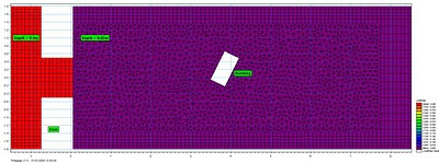
 MIKE 21 Flow Model FM point series output locations.
 Plot of water surface elevation against time for all point series output locations (m)
 Plot of velocity against time for all point series output locations (m/s)

Introduction
The following example is intended to augment the MIKE FLOOD Classic (SG) results presented within the forthcoming Environment Agency Science Report 'Benchmarking of 2D Hydraulic Modelling Packages'. Information on this study can currently be found in the 'Desktop Review of 2D Hydraulic Software Packages' report; available here (opens PDF document).
This dam break test has been adapted from an original benchmark test case available from the IMPACT project (IMPACT, 2004; Soares-Frazao and Zech, 2002), for which measurements from a physical laboratory model at the Civil Engineering Laboratory of the Université Catholique de Louvain (UCL) are available. The test involves a simple topography, a dam with a 1.0m wide opening, and an idealised representation of a single building downstream of the dam.
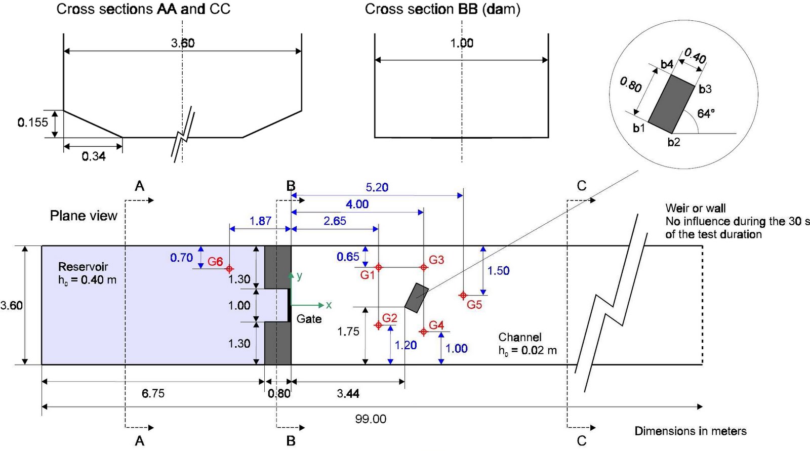
Model Set-up (adapted from Soares-Frazao and Zech, 2002).
[1] The SOARES-FRAZAO, S. AND ZECH, Y., 2002 Dam break flow experiment (Isolated building test case) is available online at http://www.impact-project.net/wp3_technical.htm
Software used
Product: MIKE FLOOD FM (Flexible Mesh)
Version: 2009 including Service Pack 3
Numerical scheme: Finite Volume (FV) [2]
Hardware used
Processor type: Intel Core 2 Quad CPU Q9450
Speed: 2.66 GHz
RAM: 4.00 GB
[2] The numerical solution of the shallow water equations (2D cases) uses an approximate Riemann solver (Roe’s scheme; Roe, 1981) to calculate the convective fluxes at the interface of the triangular and/or quadrangular cells/elements. Average gradients are estimated using the approach by Jawahar and Kamath, 2000. Numerical oscillations are avoided using a second order TVD slope limiter (Van Leer limiter; Hirch, 1990 and Darwish, 2003).
Model Parameters

Time increment (s): 0.02 (adaptive 0.001 - 0.02)
Flood and Dry: Drying depth = 0.001, Flooding depth = 0.002 & Wetting depth = 0.005
Eddy viscosity (m2/s): Smagorinsky formulation (default)
Bed resistance: Manning's M = 100


Model Results
Grid resolution (m): 38053 nodes / 38690 elements
Total simulation time (s): 149
Animation of water surface elevations in first 30-seconds of simulation (m)

Animation of velocities in first 30-seconds of simulation (m/s)


Detailed comparison of MIKE FLOOD FM modelled water surface elevations and UCL laboratory observations (click to enlarge).
Animation of water surface elevations showing development of hydraulic jump (m)
.
.
Subscribe to:
Posts
(Atom)
Follow DHI...


