Monday, 10 September 2012
Marine Renewable Energy - Meeting the Need
University of Plymouth
Monday 01 October 2012
DHI Water Environments (UK) Ltd is sponsoring the above conference / seminar day. This event brings together experts from the public and private sector to discuss the developments and opportunities for meeting the engineering challenges of delivering marine renewable energy in the South West of England.
The UK Government Coalition is committed to meeting 15% of our projected energy demand from renewable sources by 2020 in the most cost effective way, and to increase this percentage into the future. The South West Marine Energy Park (MEP) provides a focus for the development of marine renewable energy which will form part of the range of technologies needed to achieve this commitment. Read more.
DHI Group Newsletter - August 2012
Renewable energy forms the subject of the leading article in the latest DHI Group newsletter: -
We are currently witnessing a major transition – the leap from fossil fuels to renewable energy. The better part of renewable energy production is related to water and water environments. At the same time, offshore wind energy is increasingly gaining ground. Tidal and wave power production are still in their nascent days, but they are fast on the road to maturity. As such, the potential in renewable energy generation is immense and grows further as we speak. Read the full article.
Sunday, 9 September 2012
Large scale Interactive coupled 3D modelling for wave and tidal energy resource and environmental impact using MIKE Software
Scotland has substantial wave and tidal energy resources and is at the forefront of the development of marine renewable technologies and ocean energy exploitation. Wave and tidal energy devices will soon be deployed in arrays, with many sites being developed. It is therefore essential to understand how a number of multi-site developments collectively impact on the physical and biological processes over a wider region. Careful selection of array sites may enable the optimum exploitation of the resource while minimising any environmental impacts to an acceptable level.
The TeraWatt project is a £1m project funded by the Engineering and Physical Sciences Research Council through its Marine Challenge Fund. The project consortium has been established under the auspices of the Marine Alliance for Science and Technology for Scotland (MASTS) with scientists from the Universities of Heriot-Watt, Edinburgh, Highlands and Islands, Strathclyde, Swansea and Aberdeen, and Marine Scotland Science (MSS). The overarching objective of the research is to generate a suite of methodologies that can provide a better understanding of the impact of energy extraction on the resource. Approaches will also be developed that can be employed to assess the physical and ecological consequences of changes to the resource. The project objective will be met by investigating spatial changes in wave climate, physical processes affecting sediments, the shoreline & seabed, and the impacts on organisms living in the seabed, their distribution and the significance of these for other ecological processes.
MIKE by DHI software has been chosen by the TeraWatt Consortium to support their research. Coupled MIKE 3 FMHD and MIKE 21 SW models form the foundations of the adopted MIKE software platform. These core models will be augmented by MIKE 21 BW, MIKE 3 FMMT, MIKE 3 FMST, LITPACK, MIKE 3 FM ECO Lab & ABM Lab, EVA and MIKE Animator in order to consider the specific responsibilities of each partner university.
For more information about the above MIKE by DHI software, please contact Steve Flood on sjf@dhigroup.com
.
FEFLOW 6.1 is here!
We are proud to announce that FEFLOW 6.1 is now available with all new features and numerous improvements that enhance performance and usability.
 The release of FEFLOW 6.1 marks a significant milestone, making FEFLOW even more productive and intuitive. With the previous FEFLOW 6.0, a new standard user interface was introduced phasing out the classic user interface that has been used for more than 20 years. Now with FEFLOW 6.1, the migration is complete making the entire functionality from mesh generation via simulation to postprocessing available in the redesigned, modern user interface. In addition, a wide range of new functionalities are available. Click here to view highlights of the most important new features and improvements.

FEFLOW users with a valid service and maintenance agreement (SMA) will automatically receive the new version as well as new key codes. If your SMA has expired, please contact the FEFLOW sales team and they will be happy to assist you with renewing it applying special release conditions.
FEFLOW 6.1 is available for public download here.
For more information about Leapfrog Hydro and FEFLOW, please click here.
For more information about FEFLOW 6.1 or to purchase the new version, please contact the FEFLOW sales team.
.
We are proud to announce that FEFLOW 6.1 is now available with all new features and numerous improvements that enhance performance and usability.
FEFLOW users with a valid service and maintenance agreement (SMA) will automatically receive the new version as well as new key codes. If your SMA has expired, please contact the FEFLOW sales team and they will be happy to assist you with renewing it applying special release conditions.
FEFLOW 6.1 is available for public download here.
FEFLOW & LEAPFROG
Experience the complete toolset for hydrogeological modelling!
Joining the powers of the best-in-class geologic and groundwater modelling tools: Easily build detailed geologic models in Leapfrog Hydro and seamlessly transfer them to FEFLOW which can handle your most demanding groundwater simulation tasks.

For more information about Leapfrog Hydro and FEFLOW, please click here.
For more information about FEFLOW 6.1 or to purchase the new version, please contact the FEFLOW sales team.
.
Previews of MIKE by DHI Release 2012
We are gradually approaching the release of the MIKE by DHI software package 2012, which is scheduled for this October. As in previous issues of our newsletter, we would like to disclose a preview of the many new and exciting features, which we hope will improve your experience when using the software products, both with regard to usability, productivity, and enhanced applications.
MIKE FLOOD AD: fully dynamic AD-coupling
Release 2012 introduces a fully dynamic AD-coupling in MIKE FLOOD, which increases the range of applications substantially.
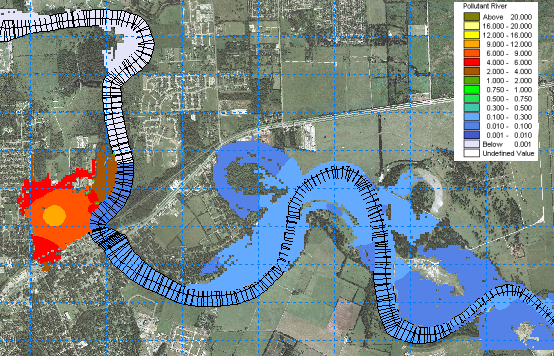 For more than a decade, MIKE FLOOD has offered complex and flexible features for coupling 1D and 2D hydrodynamic models. Flood extents and flood hazards have been some of the key issues for flood modelling. These issues will continue to be of great importance and still be focus points for many modelling applications in the future, but in addition to this, the new release of MIKE FLOOD now offers the option to simulate the transport and spreading of pollutants during a flood event through a fully dynamic coupling of the Advection Dispersion modules of MIKE 11, MIKE 21, and MIKE URBAN.
The new AD-coupling in MIKE FLOOD enables users to simulate new interesting aspects such as: -
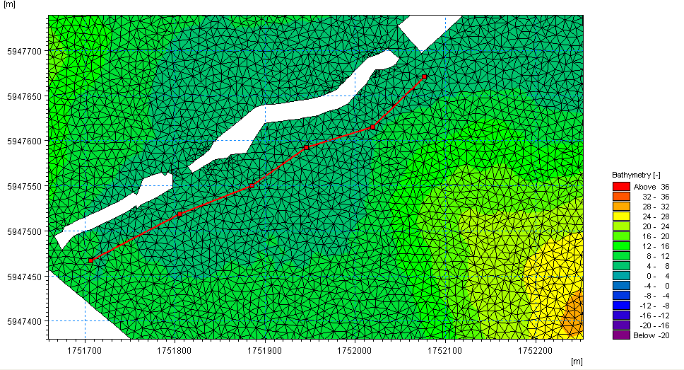 A new dike structure option has been implemented in the Flexible Mesh series of MIKE 21 and MIKE 3. Dike structures are defined by structure specific data parameters as well as location and geometry. The location in the horizontal domain is given by two or more geo-reference points (a polyline), which defines the width of the structure perpendicular to the flow direction. Each point in the polyline should be given a crest level, and it is therefore possible to obtain a spatial variation of crest elevations along a dike structure within the model domain.
Dike structures are generally used to describe local flow obstructions or other special topographical features, which are not included in the model bathymetry, and as such a highly useful feature for both coastal and inland applications. The discharge over a section covered by the dike is calculated using a standard weir expression.
MIKE SHE: Frozen soil
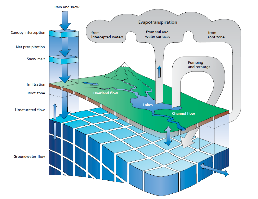 The 2012 release of MIKE SHE will contain a range of new improvements. Among these are the improvements in simulation of the annual variation of soil infiltration capacity due to freezing and thawing dynamics.
A simplified approach has been implemented, which allows the user to define a time-varying OL-UZ (Overland to Unsaturated Zone) leakage coefficient, and thereby enables the user to control the balance between infiltration and direct runoff from precipitation during all seasons of the year.
.
We are gradually approaching the release of the MIKE by DHI software package 2012, which is scheduled for this October. As in previous issues of our newsletter, we would like to disclose a preview of the many new and exciting features, which we hope will improve your experience when using the software products, both with regard to usability, productivity, and enhanced applications.
MIKE FLOOD AD: fully dynamic AD-coupling
Release 2012 introduces a fully dynamic AD-coupling in MIKE FLOOD, which increases the range of applications substantially.
The new AD-coupling in MIKE FLOOD enables users to simulate new interesting aspects such as: -
- floodplain contamination from polluted rivers
- impact assessment on river quality from pollutant sources in flood prone areas during flood events
- the impact on concentrations of river pollutant in case of a release from an urban Combined Sewer Overflow
Dike structures are generally used to describe local flow obstructions or other special topographical features, which are not included in the model bathymetry, and as such a highly useful feature for both coastal and inland applications. The discharge over a section covered by the dike is calculated using a standard weir expression.
MIKE SHE: Frozen soil
A simplified approach has been implemented, which allows the user to define a time-varying OL-UZ (Overland to Unsaturated Zone) leakage coefficient, and thereby enables the user to control the balance between infiltration and direct runoff from precipitation during all seasons of the year.
.
Previews of MIKE by DHI Release 2012
We are gradually approaching the release of the MIKE by DHI software package 2012, which is scheduled for this October. As in previous issues of our newsletter, we would like to disclose a preview of the many new and exciting features, which we hope will improve your experience when using the software products, both with regard to usability, productivity, and enhanced applications.
MIKE 21: Earthquake bathymetry adjustment tool
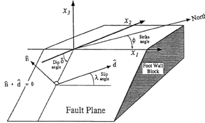 In version 2012, a new tool that can assist undertaking of Tsunami-simulations is introduced: earthquake bathymetry adjustment tool. For several years, it has been possible to work with time varying bathymetries (using the landslide option) in MIKE 21 Classic. The usability of this feature is now enhanced, as it will be easier to simulate tsunamis using the new tool. The earthquake bathymetry adjustment tool calculates sea bottom displacements that occur during an earthquake. The output is a time-varying bathymetry file, which can be used in MIKE 21 HD (classic) with the landslide option to generate wave propagation.
The method for calculation of the sea bottom displacements is an amplified version of the double-couple method developed by Okada (1985). The necessary input data for earthquakes can be retrieved from public databases. The tool is available in the MIKE 21 Toolbox in a new group called Seismology.
MIKE MARINE GIS will be discontinued
 MIKE MARINE GIS will be discontinued and will not be available on the MIKE by DHI 2012 DVD. It has been evaluated that the user base for MIKE MARINE GIS was not sufficient to maintain the programme on the Esri platform. However, in version 2012, many of the tools that were previously available through MIKE MARINE GIS, have been transferred into MIKE Zero. Thus, we are enhancing the functionalities available for most users: -
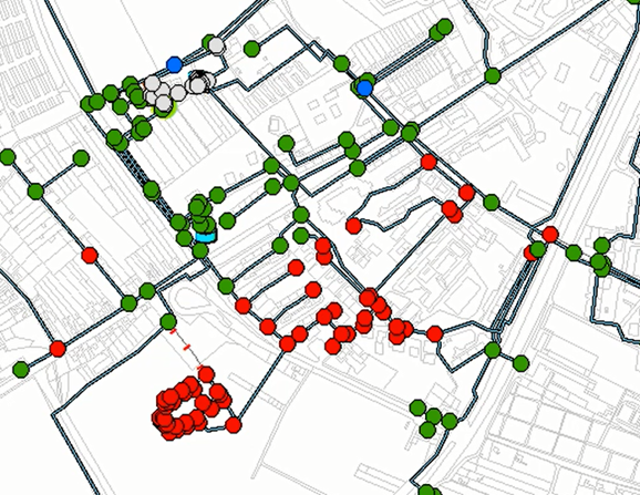 The costs of pipe failures in water distribution networks are increasing and are forcing operators and utility managers to develop strategies and solutions to identify and replace critical pipes. With the upcoming release of MIKE URBAN, a new set of advisor tools will be available to support these processes.
Pipe criticality modelling will predict how the water distribution system responds to: -
.
We are gradually approaching the release of the MIKE by DHI software package 2012, which is scheduled for this October. As in previous issues of our newsletter, we would like to disclose a preview of the many new and exciting features, which we hope will improve your experience when using the software products, both with regard to usability, productivity, and enhanced applications.
MIKE 21: Earthquake bathymetry adjustment tool
The method for calculation of the sea bottom displacements is an amplified version of the double-couple method developed by Okada (1985). The necessary input data for earthquakes can be retrieved from public databases. The tool is available in the MIKE 21 Toolbox in a new group called Seismology.
MIKE MARINE GIS will be discontinued
- Tools for creation of transects, profiles, baselines, and coastlines are included in the bathymetry editor
- The MIKE Zero tool “Geo Referencing Image File” has been extended to read and convert Esri world format files to DHI world file format
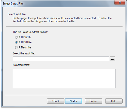
- The MIKE2SHP tool is extended to support mesh and dfsu files
Pipe criticality modelling will predict how the water distribution system responds to: -
- Pipe break situations
- Planned reconstructions
- Limited water supply
- Storage tanks: reports tanks that are either drained or overflows during the simulation, reports if the tanks are balanced within the simulation
- Pumps: reports pumps that are operated close to their maximum capacity
- Unit head loss: reports pipes with too high unit head loss
- Service pressure: reports excessive pressure that exceed the service criteria
- Pipe flow: reports reverse flow in pipes
- Flow velocity: reports excessive flow velocity
.
Subscribe to:
Posts
(Atom)
Follow DHI...


