Friday, 27 July 2012
Environment Agency to launch new Central Modelling Platform with huge MIKE by DHI software installation
 The Environment Agency has developed a Central Modelling Platform (CMP) based upon a Virtual Desktop Infrastructure solution to support their regional and national modelling efforts. Once fully implemented the CMP will service up to 500 concurrent users nationwide and will host a range of modelling software applications including MIKE by DHI. The MIKE by DHI software installation on the CMP initially includes MIKE 11, MIKE FLOOD, MIKE 21, MIKE 3, MIKE SHE, ECO Lab, MIKE 21C, LITPACK and MIKE Animator, covering a wide range of the water modelling needs of the Environment Agency.
For more information on MIKE by DHI software please contact Steve Flood on +44 (0)118 9000 745 or mikebydhi.uk@dhigroup.com
.
For more information on MIKE by DHI software please contact Steve Flood on +44 (0)118 9000 745 or mikebydhi.uk@dhigroup.com
.
Wednesday, 25 July 2012
Met-Ocean Design Conditions in the Pentland Firth
The Pentland Firth in the north of Scotland is one of the most energetic marine sites in Europe, with tidal currents reaching velocities of up to 12 knots (more than 22 km/h). That makes it highly attractive for tidal energy projects. However, the site is also exposed to severe wave conditions, making it a very challenging environment for such activities. Detailed knowledge of the local Met-Ocean conditions is required to ensure the reliability of any planned tidal devices.
 The MeyGen tidal stream project plans to build a 398MW tidal turbine array - generating the equivalent electricity to power 400,000 homes - in the Inner Sound of the Pentland Firth. In order to ensure that the foundations and turbine superstructure are not over- or under-designed, MeyGen Ltd. commissioned DHI to provide design criteria, fatigue and operational Met-Ocean data for four locations at the project site.
The study observed severe wave-current interaction occurring in the area. This occurs when tidal currents are sufficiently strong enough to alter the characteristics of the wave climate. In conditions where tidal currents oppose the waves, extremely steep waves are produced. DHI were able to simulate this process and capture waves of similar steepness to the field measurements.
DHI’s results will be used by MeyGen Ltd to further optimise their turbine design and make sure their structures are able to withstand the harshest conditions expected in their design lives. Moreover, turbine installation can be planned to maximise safety and minimise cost and downtime. Deployment of the first units is planned to commence in 2014.
For more information please contact Oliver Jones on opj@dhigroup.com or visit http://www.meygen.com/
.
The Pentland Firth in the north of Scotland is one of the most energetic marine sites in Europe, with tidal currents reaching velocities of up to 12 knots (more than 22 km/h). That makes it highly attractive for tidal energy projects. However, the site is also exposed to severe wave conditions, making it a very challenging environment for such activities. Detailed knowledge of the local Met-Ocean conditions is required to ensure the reliability of any planned tidal devices.
The study observed severe wave-current interaction occurring in the area. This occurs when tidal currents are sufficiently strong enough to alter the characteristics of the wave climate. In conditions where tidal currents oppose the waves, extremely steep waves are produced. DHI were able to simulate this process and capture waves of similar steepness to the field measurements.
DHI’s results will be used by MeyGen Ltd to further optimise their turbine design and make sure their structures are able to withstand the harshest conditions expected in their design lives. Moreover, turbine installation can be planned to maximise safety and minimise cost and downtime. Deployment of the first units is planned to commence in 2014.
For more information please contact Oliver Jones on opj@dhigroup.com or visit http://www.meygen.com/
.
Thursday, 19 July 2012

The 15th MIKE by DHI UK User Group Meeting is scheduled for 19th March 2013. Once again it will be held at the popular Lion Quays Waterside Resort, Oswestry, UK.

On the following day, 20th March 2013, training sessions and specialised seminars will be held at the same venue.
Participation in the User Group Meeting is free of charge. The Training Sessions are also free of charge to UGM participants and will include hand-outs, lunch and coffee.
If you would like to present a paper at this event please let us know.
For more information please contact: -
- Simon Matthews on 01694 722795 or sm@dhigroup.com
- Steve Flood on 01752 691723 or sjf@dhigroup.com
.

During the last years several MIKE products, in particular MIKE 21 and MIKE 3, are being used extensively for teaching and research at the School of Planning, Architecture and Civil Engineering at Queen’s University Belfast, Northern Ireland, UK.
Teaching
MIKE 21 is used on various levels of teaching in coastal engineering, both in the class-room and for projects and exercises. Some of the main themes are the estimation of design wave conditions for breakwaters and the influence of dredging on flow conditions in an estuary.
Research
MIKE software has proved to be valuable tools in various research projects, of which can be mentioned (Similarly to other universities much of the research at QUB is made or initiated in connection with thesis studies): -
- Assessment of the effects of Climate Change on wave climate
- Assessment of the environmental impacts of farms of marine energy converters
- Modeling of wave generation over sudden changes in topography
- Saline intrusion and sluice operation in an estuary
- Fate of mussel larvae and spat
- Correlation of benthic habitat composition and hydrodynamic environment
Dr. Bjöern Elsäßer, Senior Lecturer at the University, states: “No matter what type of research is carried out, the access to state-of-the-art modelling technology is of prime importance. The favourable conditions on which MIKE by DHI software can be made accessible to our Masters and PhD students is certainly a catalyst to our research. For a limited fee the student gets a personal software licence and our university licences can be used for other research and educational purposes. As consultant I’ve been using MIKE by DHI software for many years and have experienced the user-friendly tools and their continuous development as well as the unique support provided by the DHI experts. Based on this experience I felt very confident in introducing the MIKE by DHI modelling technology to QUB and to my students. The user-friendly GUI, the large number of tools within one shell, and the simplicity of getting from a setup to a running model is fantastic. This permits the research part of the thesis work to come into focus instead of only concentrating on setting-up and running a model. Furthermore, it is a pleasure to be able to follow the student’s development and observe how the skills enhance their employability in particular in the competitive working environment.”
For further information please visit http://www.qub.ac.uk/research-centres/QueensUniversityMarineLaboratory/
.
WFD Modelling with MIKE FLOOD AD (Coming soon...)
Breach Modelling Tools Available within MIKE 11, MIKE 21 and MIKE FLOOD
.
Breach Modelling Tools Available within MIKE 11, MIKE 21 and MIKE FLOOD
.
Saturday, 14 July 2012
FEFLOW 2012

3rd International FEFLOW® User Conference
3rd - 7th September 2012
Berlin, Germany
 Building on the success of the previous FEFLOW user conferences, FEFLOW 2012 will feature numerous opportunities for exchanging ideas and improving modelling skills. Highlights include keynote presentations, user presentations, product updates, opportunities to meet with DHI-WASY partners and FEFLOW users worldwide, software demonstrations, training courses, and workshops.
For further information and registration, please go to the Conference website here.
.
3rd International FEFLOW® User Conference
3rd - 7th September 2012
Berlin, Germany
For further information and registration, please go to the Conference website here.
.
Previews of MIKE by DHI Release 2012
As in previous issues of our newsletter, we would like to disclose a preview of the upcoming MIKE by DHI software package 2012, which is scheduled to be released this September. The release will contain various new and exciting features, which we hope will improve your experience when using the software products, both with regard to usability, productivity, and enhanced applications.
FEFLOW 6.1: Finding the ideal discretisation near wells and point sources
 The discretisation of point sources (like well boundary conditions) in discretised numerical model is a critical requirement if an accurate drawdown needs to be calculated. At point-type boundary conditions (such as wells or solitary fixed potentials), the element size has a direct influence on the computed drawdown or flux. If being disregarded, the result might vary by up to orders of magnitude.
As FEFLOW uses a flexible meshing technology, the user is able to adapt the element size near wells and other point sources to the necessary discretisation. This ideal node distance depends on the radius of the well in reality and the number of neighbour nodes. To facilitate the calculation and implementation of this distance, multilayer wells and borehole heat exchangers have been equipped with special viewing styles that guide the user on how to adapt the mesh to its ideal shape.
 The figures illustrate the easiness of the workflow. First, a mesh is created (e.g. using the triangle method) with an approximated node distance (6 x well radius). Afterwards, a multilayer well is created. The viewing style “ideal element size” displays a circle indicating the ideal distance of the neighbouring nodes. After manually placing the nodes on this circle, the area indicated by the “geometry“-style (well radius in reality) will be matched by the “virtual well radius” (equivalent well radius in the discretised model).
These and many new features are already available in the FEFLOW 6.1 public beta.
.
As in previous issues of our newsletter, we would like to disclose a preview of the upcoming MIKE by DHI software package 2012, which is scheduled to be released this September. The release will contain various new and exciting features, which we hope will improve your experience when using the software products, both with regard to usability, productivity, and enhanced applications.
FEFLOW 6.1: Finding the ideal discretisation near wells and point sources
As FEFLOW uses a flexible meshing technology, the user is able to adapt the element size near wells and other point sources to the necessary discretisation. This ideal node distance depends on the radius of the well in reality and the number of neighbour nodes. To facilitate the calculation and implementation of this distance, multilayer wells and borehole heat exchangers have been equipped with special viewing styles that guide the user on how to adapt the mesh to its ideal shape.
These and many new features are already available in the FEFLOW 6.1 public beta.
.

The latest MIKE by DHI NetWork newsletter (July 2012) has now been published. Selected highlights from this, and other recent, newsletters are presented below: -
Application Examples from Around the World
- MIKE 3 used for innovative project at the Maspalomas desalination plant in Spain: A new and innovative project in the Canary Islands in Spain has resulted in the successful development of an effective method for reducing the environmental impact of brine discharges on marine ecosystems. In order to mitigate the impact of large spreading brine discharges from desalination plants, which affect the benthic communities at the sea bottom, a study was made at the Maspalomas desalination plant in Gran Canaria. The feasibility study focused on applying Venturi effect ejectors in brine discharges versus conventional diffusers as a mechanism to improve the dilution processes at acceptable costs for new and existing plants. DHI contributed by developing and applying numerical models for the study of the brine dispersion, including a MIKE 3 model to simulate the brine plume far field, which was calibrated using measurements from several monitoring surveys. Read more here.
- Oil dispersion in Guanabara Bay in Rio de Janeiro, Brazil: DHI Brazil was recently requested to perform an oil dispersion modelling to support the development of an emergency plan for a port terminal in Guanabara Bay in Rio de Janeiro. As part of the emergency plan, an analysis of the effects of oil pollution incidents on the safety of life and the environment was performed, taking into account the sensitivity of the areas likely to be affected and the possibility of occurrence. The determination of these exposed areas was conducted through mathematical modelling. Thus, the hydrodynamic and oil dispersion modules of the modelling system MIKE by DHI were used to simulate different scenarios of accidental oil spills within the bay. Read more here.
- Protection of cruise terminal in Jamaica with MIKE 21: The Falmouth Terminal on the north shore of Jamaica is used by thousands of cruise line passengers each year, but the extreme hurricane events that occur in the region each year pose a flood risk of the terminal buildings. DHI performed comprehensive research and modelling to evaluate the best way to protect the cruise terminal buildings, even during extreme hurricane events in a highly complex bathymetric setting. For this purpose MIKE 21 PMS (Parabolic mild-slope) and MIKE 21 BW (Boussinesq Wave) was used to reproduce the energy dissipation due to wave breaking as well as the wave refraction and wave diffraction. Read more here.
- Uncertainty analysis to improve design criteria of wastewater treatment plants (WWTP): The Umbrella-DOUT initiative is a net of seven interconnected projects that aim at analysing how uncertainty is being tackled in wastewater treatment plant (WWTP) design. Design guidelines (Metcalf & Eddy, ATV, Grady, etc.) and safety factors are generally used to develop designs that ensure some effluent requirements (average ammonium below 3 mg/l; total nitrogen below 18 mg/l, etc.). Read more here.
- Researching the Grand-Lieu Lake in France with MIKE 21: The Science University of Nantes is using MIKE 21 software for ecosystems research of the Grand-Lieu Lake in France. The natural area of the Grand-Lieu Lake is well protected, but suffers an alarming evolution including phenomena such as fast erosion of the macrophytes belt, significantly decreasing biodiversity, early blooming of cyanobacteria phytoplankton, and negative sedimentary balance. Read more here.
- Modelling the Tohoku tsunami in Japan: One year has now passed since the tragic tsunami of 11 March 2011. Together with the Danish Authorities and especially the Royal Danish Embassy in Japan, DHI has provided assistance to Higashi Matsushima city, which is one of the hardest affected communities along the coastline of the Tohoku region. At Higashi Matsushima, the tsunami wave reached more than 10 m, propagated as far as 5 km inland, claiming at least 1039 lives of a population of 42,000, and destroyed more than 60 % of the city. Read more here.
- Modelling the 11 April mini-tsunami in the Indian Ocean: In the afternoon of 11 April 2012, an earthquake occurred 500 km off the north-western coast of Sumatra, near the region where the devastating Indian Ocean tsunami was generated in 2004. On 11 April, the earthquake was felt strongly in Sumatra, but also in Malaysia, Singapore, and even in places like Bangladesh and the Maldives. The level of awareness was high, and shortly after the earthquake a tsunami warning was issued for the entire Indian Ocean due to a well-functioning tsunami watch, which was set into effect only seven minutes after the earthquake. Fortunately, a large tsunami did not materialise. Read more here.
- Plotting MIKE 21 spill levels in MIKE FLOOD: Do you know how to compare MIKE FLOOD spill levels along lateral links with MIKE 11 longitudinal profile results? If not, click here to find a tip that will guide you through it.
To subscribe to the newsletter(s), please visit http://www.graphicmail.com/rwcode/subscribe.aspx?SiteID=3526&Mode=subscribe
.
Monday, 9 July 2012
Heavy rain floods Plymouth, Yealmpton, Modbury and surrounding communities
The morning of Saturday 7th July 2012 saw Ivybridge, Yealmpton and Modbury hit by torrential rain and floods, while there was also localised flooding in and around Plymouth with a number of roads closed to traffic and transport services disrupted. Read more from 'This is Plymouth' >>>
Flooding in Sidmouth on 7th July 2012 (video by Fizzywack)
Flooding in Yealmpton on 7th July 2012 (video by Rubysdog)
Other news articles (with pictures) from around the web: -
River Erme after the flooding on 7th July 2012 (video by S.Lowery)
More news: -
.
The morning of Saturday 7th July 2012 saw Ivybridge, Yealmpton and Modbury hit by torrential rain and floods, while there was also localised flooding in and around Plymouth with a number of roads closed to traffic and transport services disrupted. Read more from 'This is Plymouth' >>>
Flooding in Sidmouth on 7th July 2012 (video by Fizzywack)
Flooding in Yealmpton on 7th July 2012 (video by Rubysdog)
Other news articles (with pictures) from around the web: -
- http://www.bbc.co.uk/news/uk-18750430
- http://www.bbc.co.uk/news/uk-18753537
- http://www.itv.com/news/westcountry/2012-07-07/heavy-rain-leaves-properties-flooded-and-residents-trapped/
- http://www.itv.com/news/2012-07-08/communities-count-cost-of-flooding/
- http://www.dailymail.co.uk/news/article-2170056/Met-Office-warns-lives-risk-issues-highest-level-alert-3ins-rain-fall-overnight-horrendous-downpours.html
- http://www.thesun.co.uk/sol/homepage/news/4416373/Man-dies-as-deluge-continues.html
River Erme after the flooding on 7th July 2012 (video by S.Lowery)
More news: -
.
Saturday, 7 July 2012
Previews of MIKE by DHI Release 2012
As in previous issues of our newsletter, we would like to disclose a preview of the upcoming MIKE by DHI software package 2012, which is scheduled to be released this September. The release will contain various new and exciting features, which we hope will improve your experience when using the software products, both with regard to usability, productivity, and enhanced applications.
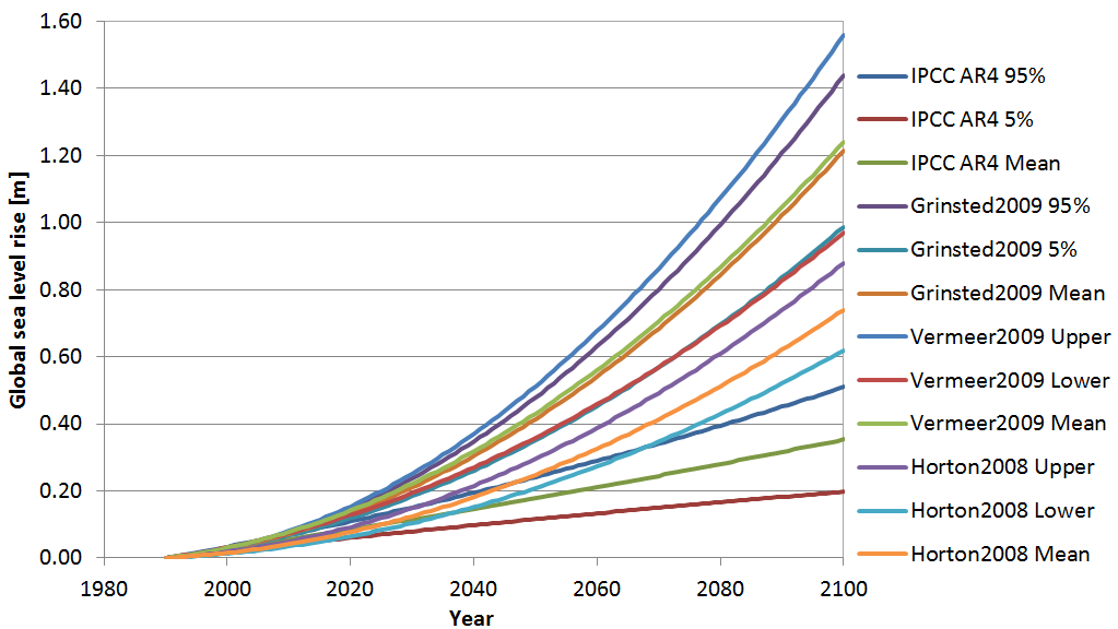
Climate Change Tool: Sea Level Rise included
One of the interesting news in version 2012 of the Climate Change Tool is that Sea Level Rise scenarios are now included. The Climate Change Tool works on existing model setups and modifies the boundary conditions according to a chosen forecast (Global Circulation Model and Emission Scenario) and forecast year.
The changes in sea level are obviously of crucial interest for a number of applications, for example related to coastal defence works. In version 2012 of the tool, global mean sea level change is included as assessed in the IPCC Assessment Report No 4 and in three posterior estimations, in all cases for three different emission scenarios.
In order to evoke the Sea Level Rise changes, the user has to define:
Click on the figure to enlarge.
FEFLOW 6.1: Watching the calibration quality
Another new feature concerns the calibration quality in FEFLOW 6.1. The calibration process is one of the most important and often most elaborate working steps when modelling groundwater systems. Having an easy and prompt response of the match between field data and computed values significantly reduces effort.
In FEFLOW 6.1, in-line visualisation of the local calibration quality at observation points assists the user during the calibration process (see figure). The deviation from the calibration target is depicted as an error bar where different colours accentuate possible violation of confidence intervals. Scatter plots finally summarise the overall match between measured and computed values.
Click on the image to enlarge.
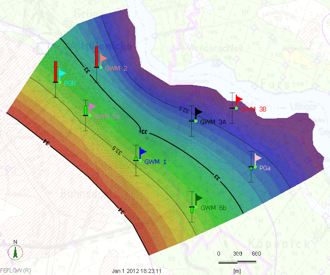
For more information, please contact Alexander Renz, DHI-Wasy, Germany.
.
As in previous issues of our newsletter, we would like to disclose a preview of the upcoming MIKE by DHI software package 2012, which is scheduled to be released this September. The release will contain various new and exciting features, which we hope will improve your experience when using the software products, both with regard to usability, productivity, and enhanced applications.
Climate Change Tool: Sea Level Rise included
One of the interesting news in version 2012 of the Climate Change Tool is that Sea Level Rise scenarios are now included. The Climate Change Tool works on existing model setups and modifies the boundary conditions according to a chosen forecast (Global Circulation Model and Emission Scenario) and forecast year.
The changes in sea level are obviously of crucial interest for a number of applications, for example related to coastal defence works. In version 2012 of the tool, global mean sea level change is included as assessed in the IPCC Assessment Report No 4 and in three posterior estimations, in all cases for three different emission scenarios.
In order to evoke the Sea Level Rise changes, the user has to define:
- Selected sea level rise model (including choice of lower, mean or upper level)
- Projection year
- Emission scenario
Click on the figure to enlarge.
FEFLOW 6.1: Watching the calibration quality
Another new feature concerns the calibration quality in FEFLOW 6.1. The calibration process is one of the most important and often most elaborate working steps when modelling groundwater systems. Having an easy and prompt response of the match between field data and computed values significantly reduces effort.
In FEFLOW 6.1, in-line visualisation of the local calibration quality at observation points assists the user during the calibration process (see figure). The deviation from the calibration target is depicted as an error bar where different colours accentuate possible violation of confidence intervals. Scatter plots finally summarise the overall match between measured and computed values.
Click on the image to enlarge.
For more information, please contact Alexander Renz, DHI-Wasy, Germany.
.
Downloading MIKE by DHI software has never been easier!
.ashx?w=200&h=135&as=1) We are pleased to announce a significant improvement in user experience with MIKE software downloads.
We are pleased to announce a significant improvement in user experience with MIKE software downloads.
This improvement is a direct result of the implementation of a new, external server hosting solution via Amazon, which facilitates easier access, greater stability, and faster download speed.
This new solution entails a number of advantages including: -
We hope that you will appreciate this new download solution!
Please note: -
.
This improvement is a direct result of the implementation of a new, external server hosting solution via Amazon, which facilitates easier access, greater stability, and faster download speed.
This new solution entails a number of advantages including: -
- Less pressure on local DHI servers due to external storage
- Scalability to servers available worldwide
- And most importantly, improved experience for users when downloading MIKE by DHI software
- In order to download our software, it merely requires a one-time registration to create a profile. When using this profile to log in to the download page, you immediately get access to multiple software downloads with no need for repeating the log in process.
We hope that you will appreciate this new download solution!
Please note: -
- When registering for the first time, we encourage you to fill out all data in the registration form, as this will help us provide you with the best possible service.
.
Catchment Management
On the 20th June ESI Ltd held their annual water industry seminar in Reading which helped celebrate the opening of their new South East regional office. This year’s conference focussed on the benefits and implications of the rapidly evolving field of catchment management.
ESI have uploaded most of the presentations to their website – here – and DHI's contribution is presented below.
Many thanks to Torsten Jacobsen for permission to use this presentation.
.
Friday, 6 July 2012
Previews of MIKE by DHI Release 2012
As in previous issues of our newsletter, we would like to disclose some previews of the upcoming MIKE by DHI software package 2012, which is scheduled to be released this September. The release will contain various new and exciting features, which we hope will improve your experience when using the software products, both with regard to usability, productivity, and enhanced applications.
MIKE 21: Rating curve boundary option in 2D overland flow models
Release 2012 introduces a new rating curve boundary option in MIKE 21.
Rating curves are relationships between water levels and discharges at a given boundary location and the calculation in MIKE 21 using rating curves therefore varies the calculated level at a boundary location in response to the outflowing discharge at that location. This functionality is new compared to existing options for defining boundaries in MIKE 21, where typically fixed or time varying values are applied for a state variable like water levels or flux. A similar Qh-boundary option has been available in MIKE 11 for a long time, and now becomes available with identical numerical functionality in all of the MIKE 21 engines (Rectilinear, Flexible Mesh, and Curvilinear) as well.
This new feature is particularly interesting for inland flood modelling, where boundary locations quite often do not have any recorded water level data. Instead, the relationship between level and discharge at the boundary location can be established and defined in MIKE 21 to allow for an alternative and flexible boundary option. Rating curves in MIKE 21 for boundary conditions are defined and saved in dfs0-files as illustrated below.
Click on the image to enlarge.

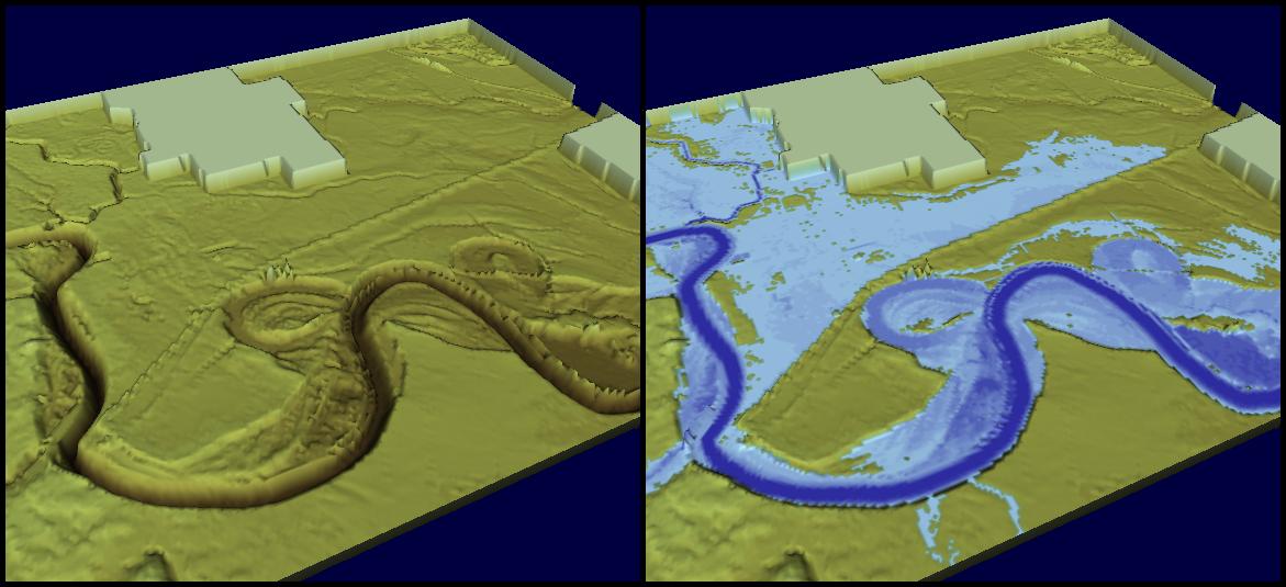
MIKE 11: Improvement of MIKE 11 mapping
A 2D-mapping feature has been available in several releases of MIKE 11 and used for generating 2D maps from either stand-alone MIKE 11 simulations or as a mapping feature for combined 2D and 1D results when running a coupled (MIKE FLOOD) simulation.
Feature improvements for outputs of 2D maps produced from combined 1D and 2D simulations are implemented in Release 2012. Primarily, bathymetry files combining both the surface and river topography can be made on-the-fly without any previously needed additional processing, but result files content from combined 2D and 1D simulations for e.g. flood mapping are also adjusted for improved results presenting and animations capability. The illustration below presents the combined 2D and 1D bathymetry at the left and a combined flood map result on the right side.
Click on the image to enlarge.
As in previous issues of our newsletter, we would like to disclose some previews of the upcoming MIKE by DHI software package 2012, which is scheduled to be released this September. The release will contain various new and exciting features, which we hope will improve your experience when using the software products, both with regard to usability, productivity, and enhanced applications.
MIKE 21: Rating curve boundary option in 2D overland flow models
Release 2012 introduces a new rating curve boundary option in MIKE 21.
Rating curves are relationships between water levels and discharges at a given boundary location and the calculation in MIKE 21 using rating curves therefore varies the calculated level at a boundary location in response to the outflowing discharge at that location. This functionality is new compared to existing options for defining boundaries in MIKE 21, where typically fixed or time varying values are applied for a state variable like water levels or flux. A similar Qh-boundary option has been available in MIKE 11 for a long time, and now becomes available with identical numerical functionality in all of the MIKE 21 engines (Rectilinear, Flexible Mesh, and Curvilinear) as well.
This new feature is particularly interesting for inland flood modelling, where boundary locations quite often do not have any recorded water level data. Instead, the relationship between level and discharge at the boundary location can be established and defined in MIKE 21 to allow for an alternative and flexible boundary option. Rating curves in MIKE 21 for boundary conditions are defined and saved in dfs0-files as illustrated below.
Click on the image to enlarge.
MIKE 11: Improvement of MIKE 11 mapping
A 2D-mapping feature has been available in several releases of MIKE 11 and used for generating 2D maps from either stand-alone MIKE 11 simulations or as a mapping feature for combined 2D and 1D results when running a coupled (MIKE FLOOD) simulation.
Feature improvements for outputs of 2D maps produced from combined 1D and 2D simulations are implemented in Release 2012. Primarily, bathymetry files combining both the surface and river topography can be made on-the-fly without any previously needed additional processing, but result files content from combined 2D and 1D simulations for e.g. flood mapping are also adjusted for improved results presenting and animations capability. The illustration below presents the combined 2D and 1D bathymetry at the left and a combined flood map result on the right side.
Click on the image to enlarge.

Many thanks to Rodrigo Pacheco Ruiz for permission to use this presentation.
.
Previews of MIKE by DHI Release 2012
As mentioned in the previous issues of our newsletter, we would like to disclose some previews of the upcoming MIKE by DHI software package 2012, which is scheduled to be released this September. The release will contain various new and exciting features, which we hope will improve your experience when using the software products, both with regard to usability, productivity, and enhanced applications.
MIKE 21: New wave spectra converter
With the primary goal to improve and ease the generation of boundary conditions for MIKE 21 SW, the upcoming 2012 version will include a new Wave Spectra Converter tool in the wave toolbox.
Boundary conditions for MIKE 21 SW are often based on integral wave parameters (significant wave height, peak wave period, mean wave direction, etc.) available from public sources. Actually, full wave spectral information is often available but it has been complicated to generate the required data for a MIKE 21 SW boundary. This new tool will solve this problem by making it possible to manipulate full wave spectra, including the generation of fully spectral boundary data for MIKE 21 SW.
Please click on the illustration to view larger version.

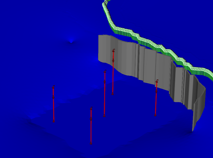
FEFLOW 6.1: Visualising the groundwater surface
With the upcoming release 2012, modelling groundwater with FEFLOW is scheduled to take an important step forward by improving the usability, comprehensibility and speeding up the workflow process.
Visualising the groundwater surface improves the understanding of groundwater models dramatically. Using the pressure, this visualisation can be achieved by restricting the parameters’ range to zero. This is already possible with FEFLOW 6.0, but requires some effort in order to adjust the view settings. With the new FEFLOW 6.1, zero pressure isosurfaces are added for the 3D and zero pressure isolines for the 2D views. Both become directly available when plotting the pressure in the view components and thus speeding up the visualisation process.
Please click on the image, to view a larger version.
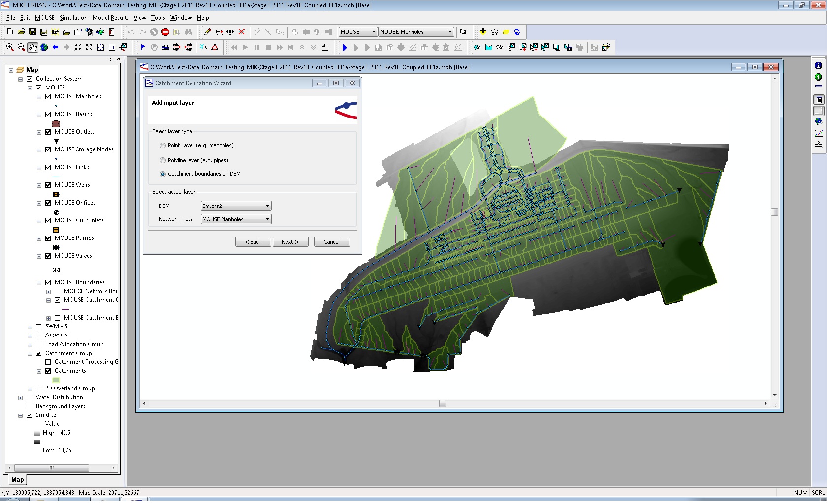
MIKE URBAN: Catchment delineation from digital elevation models
Catchment delineation is one of the essential steps for surface-runoff modelling. With MIKE URBAN version 2012 catchments, as a basic physical entity of the landscape, can be derived easily from digital elevation models (DEM). The number of available DEMs as well as the spatial resolution has been increased rapidly over the last years. Using this delineation technique will improve accuracy of the catchment delineation compared to a pure geometrical method (e.g. Thiessen polygons). The technique involved is well known as it is already utilised in MIKE BASIN.
Please click on the image to view a larger version.
As mentioned in the previous issues of our newsletter, we would like to disclose some previews of the upcoming MIKE by DHI software package 2012, which is scheduled to be released this September. The release will contain various new and exciting features, which we hope will improve your experience when using the software products, both with regard to usability, productivity, and enhanced applications.
MIKE 21: New wave spectra converter
With the primary goal to improve and ease the generation of boundary conditions for MIKE 21 SW, the upcoming 2012 version will include a new Wave Spectra Converter tool in the wave toolbox.
Boundary conditions for MIKE 21 SW are often based on integral wave parameters (significant wave height, peak wave period, mean wave direction, etc.) available from public sources. Actually, full wave spectral information is often available but it has been complicated to generate the required data for a MIKE 21 SW boundary. This new tool will solve this problem by making it possible to manipulate full wave spectra, including the generation of fully spectral boundary data for MIKE 21 SW.
Please click on the illustration to view larger version.
FEFLOW 6.1: Visualising the groundwater surface
With the upcoming release 2012, modelling groundwater with FEFLOW is scheduled to take an important step forward by improving the usability, comprehensibility and speeding up the workflow process.
Visualising the groundwater surface improves the understanding of groundwater models dramatically. Using the pressure, this visualisation can be achieved by restricting the parameters’ range to zero. This is already possible with FEFLOW 6.0, but requires some effort in order to adjust the view settings. With the new FEFLOW 6.1, zero pressure isosurfaces are added for the 3D and zero pressure isolines for the 2D views. Both become directly available when plotting the pressure in the view components and thus speeding up the visualisation process.
Please click on the image, to view a larger version.
MIKE URBAN: Catchment delineation from digital elevation models
Catchment delineation is one of the essential steps for surface-runoff modelling. With MIKE URBAN version 2012 catchments, as a basic physical entity of the landscape, can be derived easily from digital elevation models (DEM). The number of available DEMs as well as the spatial resolution has been increased rapidly over the last years. Using this delineation technique will improve accuracy of the catchment delineation compared to a pure geometrical method (e.g. Thiessen polygons). The technique involved is well known as it is already utilised in MIKE BASIN.
Please click on the image to view a larger version.
Subscribe to:
Comments
(Atom)
Follow DHI...


