Tuesday, 24 December 2013

Friday, 20 December 2013
MIKE by DHI 2014 is now available for download
 We are delighted to inform you that the new MIKE by DHI 2014 software package is available for download.
Release 2014 brings even more speed and flexibility to professional modellers around the world! If you value your time and want to discover how the world’s leading water modelling software can help you to even better productivity, please check it out. Our 30 day trial licences are free of charge!
MIKE by DHI covers the water environments in a highly integrated manner and with more features than ever before. Whether you are working within groundwater, urban water, wastewater, flooding, water resources, rivers, marine, ports or coasts - MIKE by DHI 2014 covers your modelling needs.
About MIKE by DHI 2014
JOIN AN ONLINE PRESENTATION
In January 2014, we have scheduled a number of online presentations in which you can learn more about what's new in MIKE by DHI 2014 and get the opportunity to ask questions. All times are in CET.
MORE INFORMATION
You can find more information about the new software package here.
You can also check out our new Software Catalogue 2014, which comprises information about new software features, an overview of our product offerings and much more.
MORE THAN JUST SOFTWARE
By using our software, you get access to a worldwide support system of people that are highly motivated to assist you and help you meet your deadlines. You also get access to THE ACADEMY by DHI, offering a unique selection of competence building and knowledge sharing activities, such as user events and professional training courses, enabling you to become an expert within your field. The online calendar is now updated with many new courses and events scheduled for 2014. Click here to find the next user group meeting or training course near you.
DOWNLOAD MIKE BY DHI 2014 NOW!
Download MIKE by DHI 2014 from our website at www.mikebydhi.com/download/MIKEBYDHI2014.aspx
If you have any questions about the new release, download, licences, or about our software in general, please contact mikebydhi.uk@dhigroup.com
Release 2014 brings even more speed and flexibility to professional modellers around the world! If you value your time and want to discover how the world’s leading water modelling software can help you to even better productivity, please check it out. Our 30 day trial licences are free of charge!
MIKE by DHI covers the water environments in a highly integrated manner and with more features than ever before. Whether you are working within groundwater, urban water, wastewater, flooding, water resources, rivers, marine, ports or coasts - MIKE by DHI 2014 covers your modelling needs.
About MIKE by DHI 2014
JOIN AN ONLINE PRESENTATION
In January 2014, we have scheduled a number of online presentations in which you can learn more about what's new in MIKE by DHI 2014 and get the opportunity to ask questions. All times are in CET.
- COAST AND SEA: Tuesday 21 January at 9:00 a.m. and 4:00 p.m.
- FASTER SIMULATIONS with MIKE 21 and MIKE FLOOD - use of GPUs in Release 2014: Wednesday 8 January at 4:00 p.m. and Thursday 9 January at 9:00 p.m. Sign up by sending an email to pok@dhigroup.com
- WATER RESOURCES: Wednesday 8 January at 9:00 a.m. and Thursday 9 January at 4:00 p.m. Sign up by sending an email to tsj@dhigroup.com
- CITIES: Tuesday 14 January at 9:00 a.m. and 4:00 p.m. Sign up by sending an email to mri@dhigroup.com
- GROUNDWATER AND POROUS MEDIA (FEFLOW): Wednesday 15 January at 9.00 a.m. and 5:00 p.m. Sign up by sending an email to psc@dhigroup.com
MORE INFORMATION
You can find more information about the new software package here.
You can also check out our new Software Catalogue 2014, which comprises information about new software features, an overview of our product offerings and much more.
MORE THAN JUST SOFTWARE
By using our software, you get access to a worldwide support system of people that are highly motivated to assist you and help you meet your deadlines. You also get access to THE ACADEMY by DHI, offering a unique selection of competence building and knowledge sharing activities, such as user events and professional training courses, enabling you to become an expert within your field. The online calendar is now updated with many new courses and events scheduled for 2014. Click here to find the next user group meeting or training course near you.
DOWNLOAD MIKE BY DHI 2014 NOW!
Download MIKE by DHI 2014 from our website at www.mikebydhi.com/download/MIKEBYDHI2014.aspx
If you have any questions about the new release, download, licences, or about our software in general, please contact mikebydhi.uk@dhigroup.com
Stakeholder module to MIKE HYDRO Basin
As an add-on to MIKE HYDRO Basin, it is now possible to create an interactive, web-based water allocation game, which stakeholders can play in order to improve their understanding of the likely consequences of different actions. The game is made realistic by converting the relevant MIKE HYDRO Basin model to the serious game interface developed by DHI.
Please contact us to learn how easy it is to convert your MIKE HYDRO Basin model to an engaging, yet serious game for your stakeholders!
For a demonstration of the power of serious water allocation games, and to play the Danida version, visit www.aquarepublica.com
Local Flash Flood warning System
Our Local Flash Flood Warning System uses a combination of data processing, modelling and communication tools to give you the timely and accurate forecasts required to aid in proper decision making. It considers the catchment area as a whole – including flood plain and tributaries – thereby providing a more integrated, flexible and holistic approach to forecasting flash floods.
Conventional flood warning systems mainly focus on discharge predictions in the main rivers. However, local floods in smaller streams and tributaries (not generally covered by conventional warning systems) may cause a large amount of damage – particularly in urban areas.
Our Local Flash Flood Warning System overcomes this challenge by considering the entire catchment area as a whole. The system is based on existing and newly developed components of our MIKE CUSTOMISED by DHI framework. It effectively utilises a large variety of input data, sophisticated mathematical models, and advanced hydrological analysis processes.
Some of the key benefits of the system: -
Detailed sediment transport description from our two-dimensional (2D) coastal model, combined with a shoreline evolution model can help to effectively predict long-term shoreline movements. Our solution can thereby enable long-term forecasts of impacts of coastal structures on coastal processes and thereby help maintain integrity of the coastline.
Valid predictions of long-term shoreline movements are vital to mitigate or prepare for erosion and changes in coastal stability. Our new shoreline model introduces the concept of a 1-line model for shoreline evolution within the MIKE 21 FM framework. The model can be applied to problems over a longer time scale. This is due to the simplifications imposed on the morphologic evolution of the coastal profile, when compared with the existing two-dimensional (2D) morphological model MIKE 21 Coupled FM.
Some of the key benefits of the new shoreline model: -
At DHI, our advanced modelling techniques and environmental and hydrodynamic expertise can help you identify optimal sites for aquaculture production. Our innovative solution combines our knowledge of chemical and biological conditions with the three-dimensional (3D) hydrodynamic modelling of our MIKE by DHI software.
The selection of suitable sites for marine aquaculture is essential for economically viable production. Different environmental requirements, such as light, nutrients, oxygen and water column stratification, must be taken into account, during such site selections.
With our 3D MIKE model and extensive knowledge, we can help you identify the best areas for optimal aquaculture production throughout the year. We can also calculate and quantify potential disease dispersal, helping you identify more safe places for future aquacultures location. Moreover our site selection tools can aid you in selecting sites with high dilution capacities to ensure that medical products and copper do not exceed the maximum allowable concentration.
 |
| Read more >>> |
Conventional flood warning systems mainly focus on discharge predictions in the main rivers. However, local floods in smaller streams and tributaries (not generally covered by conventional warning systems) may cause a large amount of damage – particularly in urban areas.
Our Local Flash Flood Warning System overcomes this challenge by considering the entire catchment area as a whole. The system is based on existing and newly developed components of our MIKE CUSTOMISED by DHI framework. It effectively utilises a large variety of input data, sophisticated mathematical models, and advanced hydrological analysis processes.
Some of the key benefits of the system: -
- Ability to effectively forecast local flash floods by covering the entire catchment area
- Frequent forecast updates appropriate for local dynamic rainfall events and storms
- Flexibility in terms of connecting to data sources
 |
| Read more >>> |
Valid predictions of long-term shoreline movements are vital to mitigate or prepare for erosion and changes in coastal stability. Our new shoreline model introduces the concept of a 1-line model for shoreline evolution within the MIKE 21 FM framework. The model can be applied to problems over a longer time scale. This is due to the simplifications imposed on the morphologic evolution of the coastal profile, when compared with the existing two-dimensional (2D) morphological model MIKE 21 Coupled FM.
Some of the key benefits of the new shoreline model: -
- Ability to calculate stable shoreline and shoreline envelopes and compare shoreline movements for different scenarios
- Inherent inclusion of the effects of coastal structures in the shoreline model
- Ability to make long-term predictions of coastal structure interactions and their impact on coastal processes
- Maintenance of coastal profile integrity
 |
| Read more >>> |
The selection of suitable sites for marine aquaculture is essential for economically viable production. Different environmental requirements, such as light, nutrients, oxygen and water column stratification, must be taken into account, during such site selections.
With our 3D MIKE model and extensive knowledge, we can help you identify the best areas for optimal aquaculture production throughout the year. We can also calculate and quantify potential disease dispersal, helping you identify more safe places for future aquacultures location. Moreover our site selection tools can aid you in selecting sites with high dilution capacities to ensure that medical products and copper do not exceed the maximum allowable concentration.
Wednesday, 11 December 2013
 |
| View the new Software Catalogue 2014 |
Our new Software Catalogue provides an overview of our comprehensive collection of software products for water environments. It includes information about news in MIKE by DHI Release 2014, MIKE CUSTOMISED products as well as worldwide training and knowledge sharing activities by THE ACADEMY by DHI.
Click here to read the new catalogue.
Courses & Events Calendar 2014
Thursday, 5 December 2013
Marine application
3D model (MIKE 3 FMHD with MIKE 3 FMPT)
Two simultaneous releases both made at 3.0m below the water surface. The square markers are the neutrally buoyant particles (e.g. bacteriological effluent), and these are permanently deposited (i.e. not re-suspended) upon contact with the bed. The triangular markers are negatively buoyant particles that have a positive fall velocity (e.g. sand), these are allowed to re-suspend upon contact with the bed. The reduced flow speeds near the bed (from the 3D model) can be clearly seen by the movement of the sand particles. Marker colour changes to represent the vertical position of the particle.
Riverine application
2D model (MIKE 21 FMHD with MIKE 21 FMPT)
Neutrally buoyant particles released at bed level in a river with a varying flow. The trails show the previous location of the particles (for the last 3 time steps).
MIKE to Google Earth Datum Shift
 Google Earth is using the ellipsoid WGS84 to define geo-positions on the earth. If the dfs2 file uses a projection that is based on another ellipsoid the area may not be displayed correctly compared to the satellite images. In this case it may be necessary to apply Datum shift in addition to the automatic coordinate transformation in order for the image to be located correctly.
Here you can specify the parameters needed to transfer the data from the defined map projection into the domain used by Google Earth.
You can read more about Datum Conversion in the Geodesy manual supplied with the installation (MIKE_Zero_Geodesy.pdf).
See also: http://www.arcwebservices.com/arcwebonline/services/dattrans.htm
For example: -
1195 OSGB_1936_To_WGS_1984_1
GEOGTRAN["OSGB_1936_To_WGS_1984_1",GEOGCS["GCS_OSGB_1936",DATUM["D_OSGB_1936",SPHEROID["Airy_1830",6377563.396,299.3249646]],PRIMEM["Greenwich",0.0],UNIT["Degree",0.0174532925199433]],GEOGCS["GCS_WGS_1984",DATUM["D_WGS_1984",SPHEROID["WGS_1984",6378137.0,298.257223563]],PRIMEM["Greenwich",0.0],UNIT["Degree",0.0174532925199433]],METHOD["Geocentric_Translation"],PARAMETER["X_Axis_Translation",375.0],PARAMETER["Y_Axis_Translation",-111.0],PARAMETER["Z_Axis_Translation",431.0]]
Monday, 2 December 2013
Previews of MIKE by DHI Release 2014
Approximately once a year, we release a new version of our MIKE by DHI software - and this year is no exception. We would like to reveal herewith a preview of some of the new and exciting features to be released in December. We hope these new features will improve your experience with our software products, regarding usability, productivity as well as enhanced applications.
New possibilities of including moving objects in your animations
Ever wanted to add moving objects to your animations? This is possible with Release 2014.
In the September issue of this newsletter, we included a preview of new features in MIKE Animator Plus in Release 2014. In this issue, we would like to show you an example of the possibilities of this new development.
With MIKE Animator Plus, you can create visual animations to present you model results – and as something new, you will be able to include visualisation of solids. Through the inclusion of solids, you can improve your animations significantly by enhancing realism and recognition of locations, for example by including fixed elements like buildings and dams or moving elements like ships. Release 2014 will support the placement of solids inside the model domain and allow them to move, which means that a ship can be sailing as part of the animation.
MIKE HYDRO Basin: Global prioritisation of water users
 MIKE HYDRO Basin is our new generation of integrated river basin analysis software for water resources planning and management.
MIKE HYDRO Basin was introduced with the current release 2012, containing a large number of features relevant for integrated river basin management applications. Developments continue for MIKE HYDRO Basin and the new release will introduce another very interesting new feature to modellers of river basin water allocation schemes and resources management; Global Prioritisation.
With this new feature, it is now possible to include a user defined prioritisation of water users within the basin model - regardless of their geographical location within the basin. Thus, it highly increases the applicability of MIKE HYDRO Basin for specific types of water resources management applications.
The global prioritisation of water users are defined through ‘Ranking’ number definitions, where water consumers are assigned an individual ranking number. The ranking numbers are used during simulation to prioritise consumers, in case of water shortage, in order to accommodate the water demands for these - taking into account that some users have a higher priority than others.
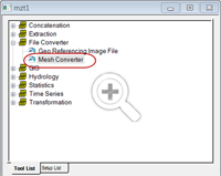
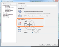
Mesh Generation: A new tool for creating flexible meshes from dfs2 files and other sources
 The combination of high flexibility of flexible meshes (FM) and impressive performance improvements, introduced in the latest releases of MIKE by DHI, make the use of FM versions of MIKE 21, MIKE 3 and MIKE FLOOD even more attractive. Improvements in recent releases include, amongst others, the introduction of shared memory based parallelisation, porting of simulation engines to LINUX and, in Release 2014, supporting Graphical Processing Units (GPUs) for MIKE 21 HD FM.
In order to assist those, who want to transfer existing models or bathymetries into the FM system, Release 2014 will contain a new tool, aimed to convert bathymetries in other formats into FM format.
The new Mesh Converter is included in the MIKE Zero Toolbox and supports DHI’s own format from the ‘classic’ modelling series, dfs2 as well as some external formats (ADCIRC, SMS, TUFLOW). The process is quick and easy and produces an equal bathymetry in FM format, which can then be modified using all the existing editing facilities of MIKE Zero’s Mesh Generator.
New features in FEFLOW 6.2
 FEFLOW 6.2 offers a number of new features to enhance your groundwater modelling work.
Storage Capture/Release is a new component in the Rate Budget and Period Budget Panels for flow and transport in FEFLOW 6.2. With this new component, you can clearly separate storage change and solution error in transient models.
Increased performance with new MIKE 1D features in MIKE URBAN
Strengthening wastewater modelling projects with new features in WEST 2014
We are also pleased to inform you that Release 2014 of WEST will include a plant wide model (PWM) for simulating nutrient removal activated sludge systems.
The plant wide model is developed jointly by our WEST Development Centres, the Universities of Cape Town (UCT) and kwaZulu-Natal in South Africa.
Approximately once a year, we release a new version of our MIKE by DHI software - and this year is no exception. We would like to reveal herewith a preview of some of the new and exciting features to be released in December. We hope these new features will improve your experience with our software products, regarding usability, productivity as well as enhanced applications.
New possibilities of including moving objects in your animations
Ever wanted to add moving objects to your animations? This is possible with Release 2014.
 |
| Click here to view an example of the possibilities of this new feature. |
With MIKE Animator Plus, you can create visual animations to present you model results – and as something new, you will be able to include visualisation of solids. Through the inclusion of solids, you can improve your animations significantly by enhancing realism and recognition of locations, for example by including fixed elements like buildings and dams or moving elements like ships. Release 2014 will support the placement of solids inside the model domain and allow them to move, which means that a ship can be sailing as part of the animation.
MIKE HYDRO Basin: Global prioritisation of water users
MIKE HYDRO Basin was introduced with the current release 2012, containing a large number of features relevant for integrated river basin management applications. Developments continue for MIKE HYDRO Basin and the new release will introduce another very interesting new feature to modellers of river basin water allocation schemes and resources management; Global Prioritisation.
With this new feature, it is now possible to include a user defined prioritisation of water users within the basin model - regardless of their geographical location within the basin. Thus, it highly increases the applicability of MIKE HYDRO Basin for specific types of water resources management applications.
The global prioritisation of water users are defined through ‘Ranking’ number definitions, where water consumers are assigned an individual ranking number. The ranking numbers are used during simulation to prioritise consumers, in case of water shortage, in order to accommodate the water demands for these - taking into account that some users have a higher priority than others.
Mesh Generation: A new tool for creating flexible meshes from dfs2 files and other sources
In order to assist those, who want to transfer existing models or bathymetries into the FM system, Release 2014 will contain a new tool, aimed to convert bathymetries in other formats into FM format.
The new Mesh Converter is included in the MIKE Zero Toolbox and supports DHI’s own format from the ‘classic’ modelling series, dfs2 as well as some external formats (ADCIRC, SMS, TUFLOW). The process is quick and easy and produces an equal bathymetry in FM format, which can then be modified using all the existing editing facilities of MIKE Zero’s Mesh Generator.
New features in FEFLOW 6.2
Groundwater age calculation in FEFLOW 6.2
Groundwater Age is a new type of problem class, similar to mass or heat transport. With this, many questions can be easily answered, such as:
- How long is the average underground travel time of water pumped at a well?
- What‘s the percentage of bank filtration at the supply wells?
- What‘s the age and remaining travel time of groundwater at a certain location?
Storage Capture/Release is a new component in the Rate Budget and Period Budget Panels for flow and transport in FEFLOW 6.2. With this new component, you can clearly separate storage change and solution error in transient models.
Increased performance with new MIKE 1D features in MIKE URBAN
In 2012, we introduced a new generic 1D numerical engine for MIKE by DHI products. With the upcoming release of MIKE URBAN 2014, a number of new features for MIKE 1D will be available such as:
- coupling to MIKE SHE
- options for Advection-Dispersion modelling
- result presentation in MIKE URBAN
- and many more…
Strengthening wastewater modelling projects with new features in WEST 2014
Our WEST software package, for modelling wastewater treatment plants, has quickly established itself as an important product in the MIKE by DHI family with a growing number of users all over the world. Release 2014 includes several important new features, including:
- New Report Generator, which enables the user to automatically create reports containing graphs and data pertaining to a project in a variety of formats including: project information, plant layout, plots and tables.
- Integrated urban water system (IUWS) libraries, making WEST a powerful tool for identifying synergies and to globally optimise the wastewater system performance on a catchment scale.
We are also pleased to inform you that Release 2014 of WEST will include a plant wide model (PWM) for simulating nutrient removal activated sludge systems.
The plant wide model, ‘PWM_SA’, is a three phase model for the simulation of nutrient removal activated sludge systems coupled with the anaerobic (organisms independent of oxygen), aerobic (organisms dependent on oxygen) and anoxic-aerobic digestion of sewage sludge. This includes waste activated sludge produced by biological excess phosphorus removal plants. The model is based on strict material mass balance and is prepared by linking:
- a variation of ASM2 for activated sludge nitrogen and phosphorus removal and aerobic or anoxic–aerobic digestion
- a variation of the UCT anaerobic digestion model.
The plant wide model is developed jointly by our WEST Development Centres, the Universities of Cape Town (UCT) and kwaZulu-Natal in South Africa.
Screencasts FEFLOW Tutorials
FEFLOW Tutorial No. 3 - User Interface
The remaining tutorials can be accessed from our FEFLOW website here, or via our YouTube channel here. The screencasts show a number of workflows in the FEFLOW user interface. The numbers of the videos refer to chapters in the FEFLOW User Manual, where all these tutorials are described in a detailed, step-by-step way.
Screencasts FEFLOW Demonstration Exercise
FEFLOW Demo Exercise No. 1 - Working with maps
The remaining demo exercises can be accessed from our FEFLOW website here, or via our YouTube channel here. These animations refer to the Demonstration Exercise that can be downloaded from manuals page. The exercise can be repeated by using the free demo version of FEFLOW available from download page.

Development of new modelling tools for national marine water planning based on ECO Lab
Our ecological modelling software, ECO Lab, will be used in a new project with the aim to develop an advanced set of dynamic modelling tools, which will be the official tools for marine water planning in Denmark in the coming years.
The project is initiated as a collaboration between DHI and Danish Centre for Environment and Energy (DCE). The project will develop and apply ecosystem models by using our MIKE by DHI software, ECO Lab, and addressing the governing coastal processes and ecosystem services such as sediment processes, sea grass, algal growth and oxygen depletion.
For more information, click here or contact Anders Erichsen, DHI.
You can also read more about ecological modelling by clicking the links below:
- Applying ECO Lab for solving ecosystem challenges
- Modelling the behaviour of organisms with ABM Lab in response to the environment
Enabling optimised construction of the London Array offshore wind farm
Our real-time system provided accurate forecasts of Metocean conditions on a detailed spatial and temporal scale for the world’s largest wind farm – London Array. This enabled London Array Ltd. – the consortium behind the wind farm – to optimise the construction of the offshore wind farm. The result: minimised delays and ensured safety for those working on the project.
Situated in the outer Thames Estuary, is the world’s largest offshore wind farm: the 1 GW London Array. Weather conditions in this area are often challenging, which made construction and installation of the wind farm difficult. As such, high-quality and reliable Metocean data was vital for the successful planning and installation of London Array’s foundations and turbines.
London Array Ltd. needed to be able to predict available weather windows. We used our 30 years of experience in Metocean forecasting for this purpose. This ensured that the London Array project benefitted from the most up-to-date and advanced technologies, combined with local experience of forecasting techniques and equipment.
By assisting London Array Ltd. with forecasting Metocean conditions, our system helped keep delays to a minimum during the construction phase. In addition, our system also enabled London Array Ltd. to efficiently plan maintenance work during the operations phase.
Read more.
CARM wins Australia’s national Environmental Engineering Excellence Award
On 20 November 2013, the Institution of Engineers Australia awarded the Computer Aided River Management (CARM) project the Environmental Engineering Excellence Award. This prestigious award honours the top achievements in environmental engineering and the sustainable use of natural resources. The award was received by our client State Water Corporation of New South Wales.
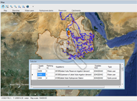
Our software is the backbone of CARM – a Decision Support System (DSS) based on MIKE CUSTOMISED by DHI components. CARM gives State Water Corporation an insight into the current and forecasted state of the Murrumbidgee River. It utilises a suite of MIKE by DHI models to reproduce key catchment and river processes for the entire 1,600 km river system, and combines them with real-time measurements. This allows river operators to combine dam releases with natural tributary inflows to deliver the right amount of water when and where it is needed.
For more information on the CARM project, click here
Read the October 2013 Edition of the DHI Group newsletter here.
Subscribe to:
Comments
(Atom)
Follow DHI...


