Showing posts with label MIKE 11. Show all posts
Showing posts with label MIKE 11. Show all posts
Tuesday, 12 August 2014
River water quality modelling using MIKE 11 ECO Lab - Vera Jones (Atkins)
Presented at the 2014 MIKE by DHI UK Symposium on 13th to 14th May 2014.
Presented at the 2014 MIKE by DHI UK Symposium on 13th to 14th May 2014.
Thursday, 8 May 2014
Unfortunately, due to time commitments, Zeinab is unable to attend the UGM and present her work in person. However, she has given us permission to distribute the abstract below. The full paper can be downloaded from http://dx.doi.org/10.1016/j.envsoft.2014.02.006
An integrated catchment-coastal modelling system for real-time water quality forecasts
Zeinab Bedri 1*, Aisling Corkery 1, John J. O’Sullivan 1, Marcos X. Alvarez 2, Anders Chr. Erichsen 3, Louise A. Deering 4, Katalin Demeter 4, Gregory O'Hare 3, Wim G.Meijer 4, and Bartholomew Masterson 4
1 Centre for Water Resources Research, School of Civil, Structural, and Environmental Engineering, University College Dublin, Belfield, Dublin 4, Ireland
2 Clarity Centre, UCD School of Computer Science and Informatics, University College Dublin, Belfield, Dublin 4, Ireland
3 DHI, Agern Alle 5, DK-2970 Hørsholm, Denmark
4 School of Biomolecular and Biomedical Science, University College Dublin, Belfield, Dublin 4, Ireland.
* Corresponding author: Tel. +353 1 716 3228, Fax: +353 1 7163297, E-mail: zeinab.bedri@ucd.ie
Abstract
This paper presents a new marine water quality forecasting system for real-time and short-term predictions. The forecasting system comprises an integrated catchment-coastal model and a database management system. The integrated model is validated in an Irish catchment-coastal system using hydrodynamic and water quality data. The forecasting system was then used to provide short-term and real-time forecasts of Escherichia Coli (E. coli) and Intestinal Enterococci concentrations (IE) in the near-shore coastal waters of Bray, Ireland. Two hind-cast scenarios were simulated: 5F in which predictions were based on rainfall forecasts only; and I-5F where forecasts of 5F were improved by incorporating real-time data. Results indicate that predictions of E. coli of scenario I-5F are improved. Also predicted IE concentrations by Scenario 5F were comparably higher than the I-5F predications, but due to the wide scatter of observed IE concentrations, the superiority of one scenario over the second could not be definitively determined.
Keywords: Real-time forecasts; integrated model; marine water quality; three-dimensional hydrodynamics; MIKE; catchment modelling

Acknowledgements
The work has been funded by an INTERREG 4A (Ireland and Wales) project. Technical support on the use of the model was provided by DHI (UK and Denmark). Thanks are extended to Dr Ahmed Nasr, Dublin Institute of Technology (DIT) for his help and useful discussions and to Mr Garrett Keane, DIT, for the assistance in the calibration of the tidal constituents of the MIKE Global model. The authors wish to acknowledge the help and information provided by Irish EPA, Bray Town council, Wicklow County council and the staff of Shanganagh Treatment works.
Article in press: Bedri, Z., et al., An integrated catchment-coastal modelling system for real-time water quality forecasts, Environmental Modelling & Software (2014), http://dx.doi.org/10.1016/j.envsoft.2014.02.006
An integrated catchment-coastal modelling system for real-time water quality forecasts
Zeinab Bedri 1*, Aisling Corkery 1, John J. O’Sullivan 1, Marcos X. Alvarez 2, Anders Chr. Erichsen 3, Louise A. Deering 4, Katalin Demeter 4, Gregory O'Hare 3, Wim G.Meijer 4, and Bartholomew Masterson 4
1 Centre for Water Resources Research, School of Civil, Structural, and Environmental Engineering, University College Dublin, Belfield, Dublin 4, Ireland
2 Clarity Centre, UCD School of Computer Science and Informatics, University College Dublin, Belfield, Dublin 4, Ireland
3 DHI, Agern Alle 5, DK-2970 Hørsholm, Denmark
4 School of Biomolecular and Biomedical Science, University College Dublin, Belfield, Dublin 4, Ireland.
* Corresponding author: Tel. +353 1 716 3228, Fax: +353 1 7163297, E-mail: zeinab.bedri@ucd.ie

Abstract
This paper presents a new marine water quality forecasting system for real-time and short-term predictions. The forecasting system comprises an integrated catchment-coastal model and a database management system. The integrated model is validated in an Irish catchment-coastal system using hydrodynamic and water quality data. The forecasting system was then used to provide short-term and real-time forecasts of Escherichia Coli (E. coli) and Intestinal Enterococci concentrations (IE) in the near-shore coastal waters of Bray, Ireland. Two hind-cast scenarios were simulated: 5F in which predictions were based on rainfall forecasts only; and I-5F where forecasts of 5F were improved by incorporating real-time data. Results indicate that predictions of E. coli of scenario I-5F are improved. Also predicted IE concentrations by Scenario 5F were comparably higher than the I-5F predications, but due to the wide scatter of observed IE concentrations, the superiority of one scenario over the second could not be definitively determined.
Keywords: Real-time forecasts; integrated model; marine water quality; three-dimensional hydrodynamics; MIKE; catchment modelling
Acknowledgements
The work has been funded by an INTERREG 4A (Ireland and Wales) project. Technical support on the use of the model was provided by DHI (UK and Denmark). Thanks are extended to Dr Ahmed Nasr, Dublin Institute of Technology (DIT) for his help and useful discussions and to Mr Garrett Keane, DIT, for the assistance in the calibration of the tidal constituents of the MIKE Global model. The authors wish to acknowledge the help and information provided by Irish EPA, Bray Town council, Wicklow County council and the staff of Shanganagh Treatment works.
Article in press: Bedri, Z., et al., An integrated catchment-coastal modelling system for real-time water quality forecasts, Environmental Modelling & Software (2014), http://dx.doi.org/10.1016/j.envsoft.2014.02.006
Thursday, 17 April 2014
Assessing The Impacts Of Rural Land Management Change On Flooding And Flood Risk (The Catchment Approach)
Following on from this post, a few more links focussing on the work of Jong-Sook Park for the Parrett catchment in SW England and its Tone subcatchment: -
Following on from this post, a few more links focussing on the work of Jong-Sook Park for the Parrett catchment in SW England and its Tone subcatchment: -
- http://www.hydrology.org.uk/assets/2010%20papers/035Park_etal.pdf
- https://workspace.imperial.ac.uk/ewre/Public/McIntyre_36.pdf
- http://riverscience.wdfiles.com/local--files/workshop-programme/Park.pdf
Representation of vegetation growth in channels and floodplains
MIKE 11 has long been able to manipulate channel roughness (Manning's n) with a time series file. This can be very useful in modelling the effect of long term vegetation growth in unmaintained river channels, and to optimise river maintenance regimes. In fact, there are a number of ways to vary roughness during a MIKE 11 simulation: -
 1) Resistance factor varies by time
Set as a boundary condition.
 2) Resistance factor varies by a function of depth, velocity, both, etc
Set as a hydrodynamic parameter.
Additionally, time varying roughness is also possible in MIKE 21 (e.g. for 2D flow on floodplains when using MIKE FLOOD). Please see the example below: -
MIKE 11 has long been able to manipulate channel roughness (Manning's n) with a time series file. This can be very useful in modelling the effect of long term vegetation growth in unmaintained river channels, and to optimise river maintenance regimes. In fact, there are a number of ways to vary roughness during a MIKE 11 simulation: -
Set as a boundary condition.
- Boundary description: Global or Distributed Source
- Boundary Type: Resistance factor
Set as a hydrodynamic parameter.
- Bed Resist. Toolbox
- Bed resistance equation: Not active, function of ln(velocity*Hydraulic Radius), function of depth, function of velocity or Table (Velocity, Resistance value)
Additionally, time varying roughness is also possible in MIKE 21 (e.g. for 2D flow on floodplains when using MIKE FLOOD). Please see the example below: -
Monday, 2 December 2013

Development of new modelling tools for national marine water planning based on ECO Lab
Our ecological modelling software, ECO Lab, will be used in a new project with the aim to develop an advanced set of dynamic modelling tools, which will be the official tools for marine water planning in Denmark in the coming years.
The project is initiated as a collaboration between DHI and Danish Centre for Environment and Energy (DCE). The project will develop and apply ecosystem models by using our MIKE by DHI software, ECO Lab, and addressing the governing coastal processes and ecosystem services such as sediment processes, sea grass, algal growth and oxygen depletion.
For more information, click here or contact Anders Erichsen, DHI.
You can also read more about ecological modelling by clicking the links below:
- Applying ECO Lab for solving ecosystem challenges
- Modelling the behaviour of organisms with ABM Lab in response to the environment
Enabling optimised construction of the London Array offshore wind farm
Our real-time system provided accurate forecasts of Metocean conditions on a detailed spatial and temporal scale for the world’s largest wind farm – London Array. This enabled London Array Ltd. – the consortium behind the wind farm – to optimise the construction of the offshore wind farm. The result: minimised delays and ensured safety for those working on the project.
Situated in the outer Thames Estuary, is the world’s largest offshore wind farm: the 1 GW London Array. Weather conditions in this area are often challenging, which made construction and installation of the wind farm difficult. As such, high-quality and reliable Metocean data was vital for the successful planning and installation of London Array’s foundations and turbines.
London Array Ltd. needed to be able to predict available weather windows. We used our 30 years of experience in Metocean forecasting for this purpose. This ensured that the London Array project benefitted from the most up-to-date and advanced technologies, combined with local experience of forecasting techniques and equipment.
By assisting London Array Ltd. with forecasting Metocean conditions, our system helped keep delays to a minimum during the construction phase. In addition, our system also enabled London Array Ltd. to efficiently plan maintenance work during the operations phase.
Read more.
CARM wins Australia’s national Environmental Engineering Excellence Award
On 20 November 2013, the Institution of Engineers Australia awarded the Computer Aided River Management (CARM) project the Environmental Engineering Excellence Award. This prestigious award honours the top achievements in environmental engineering and the sustainable use of natural resources. The award was received by our client State Water Corporation of New South Wales.
Our software is the backbone of CARM – a Decision Support System (DSS) based on MIKE CUSTOMISED by DHI components. CARM gives State Water Corporation an insight into the current and forecasted state of the Murrumbidgee River. It utilises a suite of MIKE by DHI models to reproduce key catchment and river processes for the entire 1,600 km river system, and combines them with real-time measurements. This allows river operators to combine dam releases with natural tributary inflows to deliver the right amount of water when and where it is needed.
For more information on the CARM project, click here
Read the October 2013 Edition of the DHI Group newsletter here.
Thursday, 14 November 2013
 |
| Link to ICFR 2013 Website |
Experiences in Asia and Europe
5-7 September 2013
Exeter, United Kingdom
A belated thank you to the team at the University of Exeter (David Butler, Albert Chen, Slobodan Djordjević, Michael Hammond, their colleagues and students), and their CORFU partners, for the exceptional ICFR 2013 conference held in September 2013. It was great to see so many fantastic presentations of projects featuring innovative use of MIKE by DHI software (particularly MIKE URBAN and MIKE FLOOD) and new MIKE CUSTOMISED solutions.
 |
| DHI's Ole Mark speaks at ICFR 2013 |
- Flood damage assessment for urban growth scenarios - A. S. Chen (presenter), M. J. Hammond, S. Djordjević, D. Butler
- Getting started with urban flood modelling for real-time pluvial flood forecasting - Jeanne-Rose René (presenter), Slobodan Djordjević, David Butler, Henrik Madsen, Ole Mark
The University of Exeter have also developed a CORFU Flood Damage Assessment Tool (compatible with the Multi-Coloured Manual) for MIKE 21, MIKE FLOOD and MIKE URBAN results files (i.e. dfs2 and dfsu). We hope to have more information on this tool very soon.
Tuesday, 5 November 2013
Temperature Exchange Using MIKE FLOOD AD Links
The coupling between MIKE 11 and MIKE 21 Flow Model FM has been implemented for temperature, salinity, components in the Transport module (FMAD) and components in the ECOLAB module; so a coupled (MIKE FLOOD) model can allow for the full exchange of salinity, temperature and other tracers: -
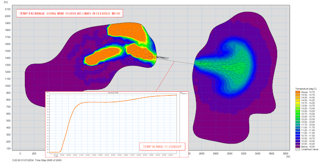
Figure: Two FM domains connect by a long culvert (MIKE 11 branch with closed cross sections), inflow far left, 3 heat sources in the upper lagoon.
The coupling between MIKE 11 and MIKE 21 Flow Model FM has been implemented for temperature, salinity, components in the Transport module (FMAD) and components in the ECOLAB module; so a coupled (MIKE FLOOD) model can allow for the full exchange of salinity, temperature and other tracers: -

Figure: Two FM domains connect by a long culvert (MIKE 11 branch with closed cross sections), inflow far left, 3 heat sources in the upper lagoon.
Monday, 20 May 2013
River Almond Valley Water Quality Modelling Strategic Study
Atkins was commissioned to produce a dynamic water quality model of the River Almond using MIKE 11 ECO Lab. Vera Jones presents the project details which considered the impacts of Scottish Water’s local assets and identified strategies for compliance with the Water Framework Directive (WFD) and Urban Wastewater Treatment Directive (UWWTD).
Atkins was commissioned to produce a dynamic water quality model of the River Almond using MIKE 11 ECO Lab. Vera Jones presents the project details which considered the impacts of Scottish Water’s local assets and identified strategies for compliance with the Water Framework Directive (WFD) and Urban Wastewater Treatment Directive (UWWTD).
Sunday, 18 November 2012
Transforming abandoned mining pits into new lake districts
The mining industry can have severe consequences for regions and the surrounding landscape, impacting vegetation and wildlife negatively when mining production is abandoned. Rehabilitating old mining areas can be a highly difficult challenge and few succeed.
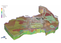 However, with the right strategies and tools available, abandoned mining pits can be turned from lifeless landscapes into prosperous manmade lake districts. This is what has been done in Eastern Germany, where DHI-WASY was able to provide accurate analysis and the right strategies for creating a new lake. For this purpose, integrated groundwater modelling was essential using among other products FEFLOW 6.1 and MIKE 11.
Click here to read more.
Read the full November 2012 Edition of the MIKE by DHI NetWork newsletter here.
Dynamic response of floating offshore wind turbines
As a member of the HYDRALAB-IV consortium, we offer access to research groups to conduct experimental studies in our wave basins. One of the projects selected by HYDRALAB's user selection panel for Transnational Access to our facilities concerns 'Dynamic Response of Floating offshore Structures under Random Waves and Wind Action'.
Other recent DHI news stories
The mining industry can have severe consequences for regions and the surrounding landscape, impacting vegetation and wildlife negatively when mining production is abandoned. Rehabilitating old mining areas can be a highly difficult challenge and few succeed.
Click here to read more.
Read the full November 2012 Edition of the MIKE by DHI NetWork newsletter here.
Dynamic response of floating offshore wind turbines
As a member of the HYDRALAB-IV consortium, we offer access to research groups to conduct experimental studies in our wave basins. One of the projects selected by HYDRALAB's user selection panel for Transnational Access to our facilities concerns 'Dynamic Response of Floating offshore Structures under Random Waves and Wind Action'.
Other recent DHI news stories
- We support IMPAQ in investigating zooplankton impacts on larval fish growth
- Development of innovative technology for treatment of hospital wastewater
- Testing floating wind turbines in DHI’s offshore basin
- We sign a new real-time forecasting contract with Slovenia
- EUPORIAS – the next step in seasonal forecasting
- Decommissioning a former nuclear weapons manufacturing facility
- We help to drive European wave and tidal power generation forward
Friday, 6 July 2012
Previews of MIKE by DHI Release 2012
As in previous issues of our newsletter, we would like to disclose some previews of the upcoming MIKE by DHI software package 2012, which is scheduled to be released this September. The release will contain various new and exciting features, which we hope will improve your experience when using the software products, both with regard to usability, productivity, and enhanced applications.
MIKE 21: Rating curve boundary option in 2D overland flow models
Release 2012 introduces a new rating curve boundary option in MIKE 21.
Rating curves are relationships between water levels and discharges at a given boundary location and the calculation in MIKE 21 using rating curves therefore varies the calculated level at a boundary location in response to the outflowing discharge at that location. This functionality is new compared to existing options for defining boundaries in MIKE 21, where typically fixed or time varying values are applied for a state variable like water levels or flux. A similar Qh-boundary option has been available in MIKE 11 for a long time, and now becomes available with identical numerical functionality in all of the MIKE 21 engines (Rectilinear, Flexible Mesh, and Curvilinear) as well.
This new feature is particularly interesting for inland flood modelling, where boundary locations quite often do not have any recorded water level data. Instead, the relationship between level and discharge at the boundary location can be established and defined in MIKE 21 to allow for an alternative and flexible boundary option. Rating curves in MIKE 21 for boundary conditions are defined and saved in dfs0-files as illustrated below.
Click on the image to enlarge.

MIKE 11: Improvement of MIKE 11 mapping
A 2D-mapping feature has been available in several releases of MIKE 11 and used for generating 2D maps from either stand-alone MIKE 11 simulations or as a mapping feature for combined 2D and 1D results when running a coupled (MIKE FLOOD) simulation.
Feature improvements for outputs of 2D maps produced from combined 1D and 2D simulations are implemented in Release 2012. Primarily, bathymetry files combining both the surface and river topography can be made on-the-fly without any previously needed additional processing, but result files content from combined 2D and 1D simulations for e.g. flood mapping are also adjusted for improved results presenting and animations capability. The illustration below presents the combined 2D and 1D bathymetry at the left and a combined flood map result on the right side.
Click on the image to enlarge.
As in previous issues of our newsletter, we would like to disclose some previews of the upcoming MIKE by DHI software package 2012, which is scheduled to be released this September. The release will contain various new and exciting features, which we hope will improve your experience when using the software products, both with regard to usability, productivity, and enhanced applications.
MIKE 21: Rating curve boundary option in 2D overland flow models
Release 2012 introduces a new rating curve boundary option in MIKE 21.
Rating curves are relationships between water levels and discharges at a given boundary location and the calculation in MIKE 21 using rating curves therefore varies the calculated level at a boundary location in response to the outflowing discharge at that location. This functionality is new compared to existing options for defining boundaries in MIKE 21, where typically fixed or time varying values are applied for a state variable like water levels or flux. A similar Qh-boundary option has been available in MIKE 11 for a long time, and now becomes available with identical numerical functionality in all of the MIKE 21 engines (Rectilinear, Flexible Mesh, and Curvilinear) as well.
This new feature is particularly interesting for inland flood modelling, where boundary locations quite often do not have any recorded water level data. Instead, the relationship between level and discharge at the boundary location can be established and defined in MIKE 21 to allow for an alternative and flexible boundary option. Rating curves in MIKE 21 for boundary conditions are defined and saved in dfs0-files as illustrated below.
Click on the image to enlarge.
MIKE 11: Improvement of MIKE 11 mapping
A 2D-mapping feature has been available in several releases of MIKE 11 and used for generating 2D maps from either stand-alone MIKE 11 simulations or as a mapping feature for combined 2D and 1D results when running a coupled (MIKE FLOOD) simulation.
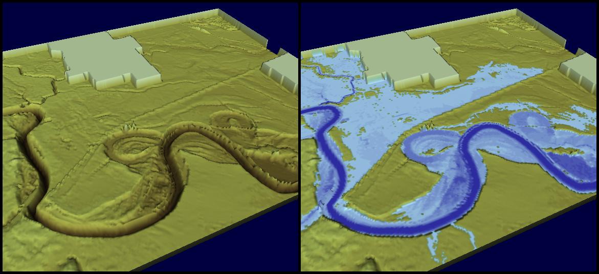
Feature improvements for outputs of 2D maps produced from combined 1D and 2D simulations are implemented in Release 2012. Primarily, bathymetry files combining both the surface and river topography can be made on-the-fly without any previously needed additional processing, but result files content from combined 2D and 1D simulations for e.g. flood mapping are also adjusted for improved results presenting and animations capability. The illustration below presents the combined 2D and 1D bathymetry at the left and a combined flood map result on the right side.
Click on the image to enlarge.
Tuesday, 3 May 2011
Applications of MIKE FLOOD in the UK by Waterco
Waterco are experienced MIKE 11 and MIKE FLOOD users, and strong advocates of the MIKE by DHI suite of integrated water modelling software tools. Waterco have been successfully employing both MIKE 11 and MIKE FLOOD, for more than five years, to undertake the modelling and assessment of flood risk in England and Wales. The animations below showcase the use of MIKE Animator to effectively communicate flood risk, from a number of different sources, to both Local Planning Authority and private clients: -
.
Waterco are experienced MIKE 11 and MIKE FLOOD users, and strong advocates of the MIKE by DHI suite of integrated water modelling software tools. Waterco have been successfully employing both MIKE 11 and MIKE FLOOD, for more than five years, to undertake the modelling and assessment of flood risk in England and Wales. The animations below showcase the use of MIKE Animator to effectively communicate flood risk, from a number of different sources, to both Local Planning Authority and private clients: -
- Coastal breach assessment
- Integrated 1D / 2D fluvial floodplain model
- Urban flooding due to blocked culvert
- Integrated 1D / 2D river model
- Pluvial / surface water flooding
Project animations prepared by Waterco using: -
For more information, please contact Chris Lewis at Waterco by phone on 01824 702220, e-mail Chris.Lewis@waterco.co.uk, or visit http://www.waterco.co.uk/
- MIKE 11 (Read more » )
- MIKE FLOOD (Read more » )
- MIKE Animator (Read more » )
For more information, please contact Chris Lewis at Waterco by phone on 01824 702220, e-mail Chris.Lewis@waterco.co.uk, or visit http://www.waterco.co.uk/
UPDATE: For more examples of MIKE 11, MIKE 21 and MIKE FLOOD applications please see Waterco's YouTube channel here http://www.youtube.com/WatercoLtd
Friday, 31 December 2010
Water Resources
Developments in Release 2011 common to all Water Resources Packages:
MIKE FLOOD
In a recent independent review carried out for the UK Environment Agency, MIKE FLOOD received the highest marks - not only for speed but also for model setup, runtime, stability, presentation and visualisation of results, sensitivity tests and file management. MIKE FLOOD achieved the highest overall score in the study. In Release 2011, there are further improvements in both speed and usability.
User interface

New linkage features
MIKE 11
MIKE 1D is a re-engineering project of MOUSE and MIKE 11 simulation engines. The outcome is one common engine for both products. A subset of the complete functionality will be available with the 2011 Release and will ensure faster simulations, 64-bit combability, parallel processing and enhanced interfacing of coupled river-urban simulations.
Client requested MIKE 11 enhancements:
MIKE SHE
Complex water quality modelling of multispecies, kinetic reactions is now available in MIKE SHE using ECO Lab. ECO Lab opens a whole range of new opportunities for comprehensive and flexible water quality and ecohydrology modelling in the overland flow, unsaturated zone and groundwater.
Further, MIKE SHE can now use a fine scale DEM for detailed flooding without seriously impacting runtime.
MIKE BASIN
The irrigation functionality of MIKE BASIN has been extended with alternative runoff and soil water options in Release 2011.
Furthermore, MIKE BASIN has been extended for simulation of crop water requirements and crop yield for rice.
FEFLOW
The HD-coupling between FEFLOW and MIKE 11 have been present for years. With the 2011 Release it is now being supplemented with AD-Coupling for simultaneous HD+AD simulations.
.
Developments in Release 2011 common to all Water Resources Packages:
- Climate change functionality
- Parallelisation
- 64-bit applications
- Autocalibration for multicore PCs
MIKE FLOOD
In a recent independent review carried out for the UK Environment Agency, MIKE FLOOD received the highest marks - not only for speed but also for model setup, runtime, stability, presentation and visualisation of results, sensitivity tests and file management. MIKE FLOOD achieved the highest overall score in the study. In Release 2011, there are further improvements in both speed and usability.
User interface
- Reorganised ‘Links Definition’ page which enables an enlarged map view
- Direct access to bathymetry and cross-sections from the map view
- Displaying cross-sections in the map view
- New main menu dialogues for Setting default values of new links and Global change of parameters for links

New linkage features
- New link option - MIKE 11 side structures linked to MIKE 21
- Time dependent levee levels
- Automatic splitting of lateral links into a user-defined number of shorter segments
MIKE 11
MIKE 1D is a re-engineering project of MOUSE and MIKE 11 simulation engines. The outcome is one common engine for both products. A subset of the complete functionality will be available with the 2011 Release and will ensure faster simulations, 64-bit combability, parallel processing and enhanced interfacing of coupled river-urban simulations.
Client requested MIKE 11 enhancements:
- Cross-section editor; automatic update of markers at levees
- Improved copy & paste capabilities
- Additional level in grid points dialogue (Network Editor)
- Executable for batch calculation of Structures Qh relations
MIKE SHE
Complex water quality modelling of multispecies, kinetic reactions is now available in MIKE SHE using ECO Lab. ECO Lab opens a whole range of new opportunities for comprehensive and flexible water quality and ecohydrology modelling in the overland flow, unsaturated zone and groundwater.
Further, MIKE SHE can now use a fine scale DEM for detailed flooding without seriously impacting runtime.
MIKE BASIN
The irrigation functionality of MIKE BASIN has been extended with alternative runoff and soil water options in Release 2011.
Furthermore, MIKE BASIN has been extended for simulation of crop water requirements and crop yield for rice.
FEFLOW
The HD-coupling between FEFLOW and MIKE 11 have been present for years. With the 2011 Release it is now being supplemented with AD-Coupling for simultaneous HD+AD simulations.
.
Subscribe to:
Posts
(Atom)
Follow DHI...


