Showing posts with label MIKE FLOOD. Show all posts
Showing posts with label MIKE FLOOD. Show all posts
Tuesday, 22 April 2014

Date: 13th to 14th May 2014
Venue: Coombe Abbey Hotel, Warwickshire, UK
Cost: Free event (excepting accommodation costs - see below)
Registration: http://www.mikebydhi.com/GlobalEvents/UKUGM2014.aspx
We are now very close to finalising the agenda for the 2014 MIKE by DHI UK Symposium (see below). This event hosts our annual User Group Meeting as well as a free-of-charge Training Day. For the latter, we are aiming to provide discussion led, seminar style training sessions in a diverse range of subjects including: -
- Wave transformation, overtopping of coastal defences and flooding (MIKE 21 BW 1D & MIKE 21 FMHD)
- Fully integrated riverine, urban pipe & overland flow flood modelling (MIKE FLOOD 3-way Coupling & Flexible Mesh)
- Introduction to FEFLOW
Monday, 21 April 2014
Discharge calculator for MIKE Zero 2014 64-bit
A simple extension to the standard MIKE 21 Discharge Calculation tool that adds support for multiple cross sections. The points defining the cross sections must be given as j,k (grid) coordinates, and written in a text file as follows: -
Notes: -
A simple extension to the standard MIKE 21 Discharge Calculation tool that adds support for multiple cross sections. The points defining the cross sections must be given as j,k (grid) coordinates, and written in a text file as follows: -
ExampleFor installation, you need to have MIKE Zero 2014 64-bit on your PC. It does not need to be located in any specific place, simply copy and unzip to any folder. We have also attached a template text file with j,k coordinates.
! j1,k1 j2,k2 Name
50,50 55,55 firstCRS
50,75 55,80 secondCRS
55,80 60,85 thirdCRS
60,85 65,90 forthCRS
65,90 70,95 fifthCRS
Notes: -
- Care should be taken when using the tool with MIKE 11 Maps output (h,p,q) to calculate combined discharges for rivers and floodplains. If a 1D river channel is very nearly sub-grid (i.e. the MIKE 11 channel occupies only one MIKE 21 cell), the 2D resolution across the river may not be sufficiently fine to accurately calculate the topographic properties (e.g. local water depth), and hence the discharge component, of the river channel. In such cases you should run the tool on the MIKE 21 results (e.g. floodplain flows only) and add the calculated discharges to 1D discharges exported from MIKE 11 (e.g. from within MIKE View).
- Generally, there is a high degree of uncertainty in providing combined discharges at river nodes; for example, the orientation of the cross section will vary the calculated discharge (flows will be different if the ‘cross sections’ are normal to either the river channel or valley itself), similarly integrating discrete points within the main river bed in 2D may deviate from the 1D discharge results at the same location, some floodplain configurations are not conducive to calculating a single combined flow rate, etc. As such, we would require that you undertake to verify the derived outputs to satisfy your own quality assurance procedures (as you would with any numerical modelling exercise).
- Please be aware that this tool is non-commercial and is provided ‘as is’ without warranty. The tool has not been subjected to the same rigorous validation and improvement / update programme as our commercial software and, as such, is to be used at your own risk. The functionality and accuracy of the tool must be checked and verified prior to use.
Thursday, 17 April 2014
Representation of vegetation growth in channels and floodplains
MIKE 11 has long been able to manipulate channel roughness (Manning's n) with a time series file. This can be very useful in modelling the effect of long term vegetation growth in unmaintained river channels, and to optimise river maintenance regimes. In fact, there are a number of ways to vary roughness during a MIKE 11 simulation: -
 1) Resistance factor varies by time
Set as a boundary condition.
 2) Resistance factor varies by a function of depth, velocity, both, etc
Set as a hydrodynamic parameter.
Additionally, time varying roughness is also possible in MIKE 21 (e.g. for 2D flow on floodplains when using MIKE FLOOD). Please see the example below: -
MIKE 11 has long been able to manipulate channel roughness (Manning's n) with a time series file. This can be very useful in modelling the effect of long term vegetation growth in unmaintained river channels, and to optimise river maintenance regimes. In fact, there are a number of ways to vary roughness during a MIKE 11 simulation: -
Set as a boundary condition.
- Boundary description: Global or Distributed Source
- Boundary Type: Resistance factor
Set as a hydrodynamic parameter.
- Bed Resist. Toolbox
- Bed resistance equation: Not active, function of ln(velocity*Hydraulic Radius), function of depth, function of velocity or Table (Velocity, Resistance value)
Additionally, time varying roughness is also possible in MIKE 21 (e.g. for 2D flow on floodplains when using MIKE FLOOD). Please see the example below: -
Friday, 20 December 2013
Local Flash Flood warning System
Our Local Flash Flood Warning System uses a combination of data processing, modelling and communication tools to give you the timely and accurate forecasts required to aid in proper decision making. It considers the catchment area as a whole – including flood plain and tributaries – thereby providing a more integrated, flexible and holistic approach to forecasting flash floods.
Conventional flood warning systems mainly focus on discharge predictions in the main rivers. However, local floods in smaller streams and tributaries (not generally covered by conventional warning systems) may cause a large amount of damage – particularly in urban areas.
Our Local Flash Flood Warning System overcomes this challenge by considering the entire catchment area as a whole. The system is based on existing and newly developed components of our MIKE CUSTOMISED by DHI framework. It effectively utilises a large variety of input data, sophisticated mathematical models, and advanced hydrological analysis processes.
Some of the key benefits of the system: -
Detailed sediment transport description from our two-dimensional (2D) coastal model, combined with a shoreline evolution model can help to effectively predict long-term shoreline movements. Our solution can thereby enable long-term forecasts of impacts of coastal structures on coastal processes and thereby help maintain integrity of the coastline.
Valid predictions of long-term shoreline movements are vital to mitigate or prepare for erosion and changes in coastal stability. Our new shoreline model introduces the concept of a 1-line model for shoreline evolution within the MIKE 21 FM framework. The model can be applied to problems over a longer time scale. This is due to the simplifications imposed on the morphologic evolution of the coastal profile, when compared with the existing two-dimensional (2D) morphological model MIKE 21 Coupled FM.
Some of the key benefits of the new shoreline model: -
At DHI, our advanced modelling techniques and environmental and hydrodynamic expertise can help you identify optimal sites for aquaculture production. Our innovative solution combines our knowledge of chemical and biological conditions with the three-dimensional (3D) hydrodynamic modelling of our MIKE by DHI software.
The selection of suitable sites for marine aquaculture is essential for economically viable production. Different environmental requirements, such as light, nutrients, oxygen and water column stratification, must be taken into account, during such site selections.
With our 3D MIKE model and extensive knowledge, we can help you identify the best areas for optimal aquaculture production throughout the year. We can also calculate and quantify potential disease dispersal, helping you identify more safe places for future aquacultures location. Moreover our site selection tools can aid you in selecting sites with high dilution capacities to ensure that medical products and copper do not exceed the maximum allowable concentration.
 |
| Read more >>> |
Conventional flood warning systems mainly focus on discharge predictions in the main rivers. However, local floods in smaller streams and tributaries (not generally covered by conventional warning systems) may cause a large amount of damage – particularly in urban areas.
Our Local Flash Flood Warning System overcomes this challenge by considering the entire catchment area as a whole. The system is based on existing and newly developed components of our MIKE CUSTOMISED by DHI framework. It effectively utilises a large variety of input data, sophisticated mathematical models, and advanced hydrological analysis processes.
Some of the key benefits of the system: -
- Ability to effectively forecast local flash floods by covering the entire catchment area
- Frequent forecast updates appropriate for local dynamic rainfall events and storms
- Flexibility in terms of connecting to data sources
 |
| Read more >>> |
Valid predictions of long-term shoreline movements are vital to mitigate or prepare for erosion and changes in coastal stability. Our new shoreline model introduces the concept of a 1-line model for shoreline evolution within the MIKE 21 FM framework. The model can be applied to problems over a longer time scale. This is due to the simplifications imposed on the morphologic evolution of the coastal profile, when compared with the existing two-dimensional (2D) morphological model MIKE 21 Coupled FM.
Some of the key benefits of the new shoreline model: -
- Ability to calculate stable shoreline and shoreline envelopes and compare shoreline movements for different scenarios
- Inherent inclusion of the effects of coastal structures in the shoreline model
- Ability to make long-term predictions of coastal structure interactions and their impact on coastal processes
- Maintenance of coastal profile integrity
 |
| Read more >>> |
The selection of suitable sites for marine aquaculture is essential for economically viable production. Different environmental requirements, such as light, nutrients, oxygen and water column stratification, must be taken into account, during such site selections.
With our 3D MIKE model and extensive knowledge, we can help you identify the best areas for optimal aquaculture production throughout the year. We can also calculate and quantify potential disease dispersal, helping you identify more safe places for future aquacultures location. Moreover our site selection tools can aid you in selecting sites with high dilution capacities to ensure that medical products and copper do not exceed the maximum allowable concentration.
Monday, 2 December 2013

Development of new modelling tools for national marine water planning based on ECO Lab
Our ecological modelling software, ECO Lab, will be used in a new project with the aim to develop an advanced set of dynamic modelling tools, which will be the official tools for marine water planning in Denmark in the coming years.
The project is initiated as a collaboration between DHI and Danish Centre for Environment and Energy (DCE). The project will develop and apply ecosystem models by using our MIKE by DHI software, ECO Lab, and addressing the governing coastal processes and ecosystem services such as sediment processes, sea grass, algal growth and oxygen depletion.
For more information, click here or contact Anders Erichsen, DHI.
You can also read more about ecological modelling by clicking the links below:
- Applying ECO Lab for solving ecosystem challenges
- Modelling the behaviour of organisms with ABM Lab in response to the environment
Enabling optimised construction of the London Array offshore wind farm
Our real-time system provided accurate forecasts of Metocean conditions on a detailed spatial and temporal scale for the world’s largest wind farm – London Array. This enabled London Array Ltd. – the consortium behind the wind farm – to optimise the construction of the offshore wind farm. The result: minimised delays and ensured safety for those working on the project.
Situated in the outer Thames Estuary, is the world’s largest offshore wind farm: the 1 GW London Array. Weather conditions in this area are often challenging, which made construction and installation of the wind farm difficult. As such, high-quality and reliable Metocean data was vital for the successful planning and installation of London Array’s foundations and turbines.
London Array Ltd. needed to be able to predict available weather windows. We used our 30 years of experience in Metocean forecasting for this purpose. This ensured that the London Array project benefitted from the most up-to-date and advanced technologies, combined with local experience of forecasting techniques and equipment.
By assisting London Array Ltd. with forecasting Metocean conditions, our system helped keep delays to a minimum during the construction phase. In addition, our system also enabled London Array Ltd. to efficiently plan maintenance work during the operations phase.
Read more.
CARM wins Australia’s national Environmental Engineering Excellence Award
On 20 November 2013, the Institution of Engineers Australia awarded the Computer Aided River Management (CARM) project the Environmental Engineering Excellence Award. This prestigious award honours the top achievements in environmental engineering and the sustainable use of natural resources. The award was received by our client State Water Corporation of New South Wales.
Our software is the backbone of CARM – a Decision Support System (DSS) based on MIKE CUSTOMISED by DHI components. CARM gives State Water Corporation an insight into the current and forecasted state of the Murrumbidgee River. It utilises a suite of MIKE by DHI models to reproduce key catchment and river processes for the entire 1,600 km river system, and combines them with real-time measurements. This allows river operators to combine dam releases with natural tributary inflows to deliver the right amount of water when and where it is needed.
For more information on the CARM project, click here
Read the October 2013 Edition of the DHI Group newsletter here.
Thursday, 14 November 2013
 |
| Link to ICFR 2013 Website |
Experiences in Asia and Europe
5-7 September 2013
Exeter, United Kingdom
A belated thank you to the team at the University of Exeter (David Butler, Albert Chen, Slobodan Djordjević, Michael Hammond, their colleagues and students), and their CORFU partners, for the exceptional ICFR 2013 conference held in September 2013. It was great to see so many fantastic presentations of projects featuring innovative use of MIKE by DHI software (particularly MIKE URBAN and MIKE FLOOD) and new MIKE CUSTOMISED solutions.
 |
| DHI's Ole Mark speaks at ICFR 2013 |
- Flood damage assessment for urban growth scenarios - A. S. Chen (presenter), M. J. Hammond, S. Djordjević, D. Butler
- Getting started with urban flood modelling for real-time pluvial flood forecasting - Jeanne-Rose René (presenter), Slobodan Djordjević, David Butler, Henrik Madsen, Ole Mark
The University of Exeter have also developed a CORFU Flood Damage Assessment Tool (compatible with the Multi-Coloured Manual) for MIKE 21, MIKE FLOOD and MIKE URBAN results files (i.e. dfs2 and dfsu). We hope to have more information on this tool very soon.
Tuesday, 5 November 2013
Temperature Exchange Using MIKE FLOOD AD Links
The coupling between MIKE 11 and MIKE 21 Flow Model FM has been implemented for temperature, salinity, components in the Transport module (FMAD) and components in the ECOLAB module; so a coupled (MIKE FLOOD) model can allow for the full exchange of salinity, temperature and other tracers: -
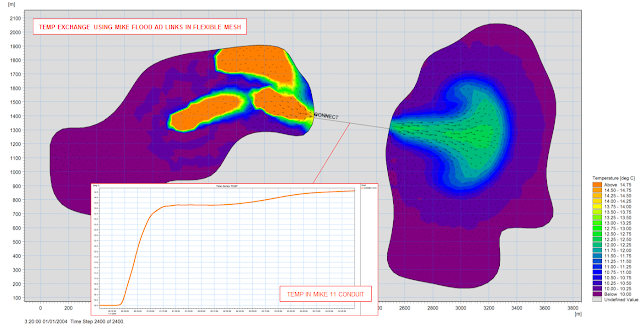
Figure: Two FM domains connect by a long culvert (MIKE 11 branch with closed cross sections), inflow far left, 3 heat sources in the upper lagoon.
The coupling between MIKE 11 and MIKE 21 Flow Model FM has been implemented for temperature, salinity, components in the Transport module (FMAD) and components in the ECOLAB module; so a coupled (MIKE FLOOD) model can allow for the full exchange of salinity, temperature and other tracers: -

Figure: Two FM domains connect by a long culvert (MIKE 11 branch with closed cross sections), inflow far left, 3 heat sources in the upper lagoon.
Monday, 4 November 2013
Previews of MIKE by DHI Release 2014
Approximately once a year, we release a new version of our MIKE by DHI software - and this year is no exception. We would like to reveal herewith a preview of some of the new and exciting features to be released later this year. We hope these new features will improve your experience with our software products, regarding usability, productivity as well as enhanced applications.
Introducing MIKE 21 GPU
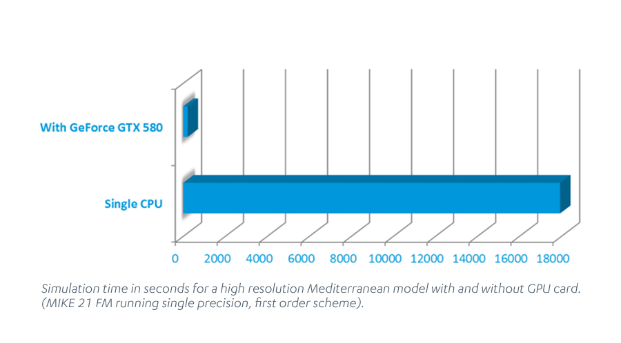
If you are using MIKE 21 FM HD or Flexible Mesh solver with MIKE FLOOD, you are getting a pleasant surprise with Release 2014! With the new release, your update package will automatically include a brand new version of the MIKE 21 FM HD module. The new version, MIKE 21 GPU (Graphical Processor Units), is “GPU-card enabled”. This means that it is able to use the graphics card on your PC to speed up simulations significantly.
 Speed up you models
Depending on the model setup and the type of GPU, the speed-up can be a factor 100 or more compared to running the same simulation on a single processor CPU.
For some model setups and GPUs, this also means that MIKE 21 FM is now faster than MIKE 21 “Classic” - the single grid version of MIKE 21 HD - when using exactly the same rectangular mesh.
The technology behind MIKE 21 GPU: How does it work?
The computational engine of MIKE 21 FM HD has been reprogrammed to make use of the latest graphical processor units - hardware that is otherwise typically used for speeding up computer games.
How will I get MIKE 21 GPU?
MIKE 21 GPU will become available, at no extra cost, to all owners of corporate licences of MIKE 21 or MIKE FLOOD with valid SMA. This means that there will be no licence fee and no increase in SMA costs. If you do not have a valid SMA or if you own a personal licence, you will be able to purchase it as an upgrade to your existing software.
Where can I read more about MIKE 21 GPU?
We have produced a detailed performance report, including comparisons of the performance of MIKE 21 GPU with the non-GPU enabled MIKE 21 FM HD. Click here to read the report.
For more information about MIKE 21 GPU, check out future issues of this new newsletter or contact our software support team.
Introducing exciting new possibilities in MIKE Animator Plus
Version 2012 of MIKE by DHI included a completely re-engineered version of MIKE Animator, designed to be a very flexible tool for producing high quality video animations of modelling results. The most prominent new features in version 2012 were the support of MIKE 3 files (including the ability to slice and take out transects and iso-surfaces) and also improved picture draping functionality.
We have continued the development of MIKE Animator Plus and version 2014 will contain three new and interesting possibilities:
 Visualisation of solids: Enhancing realism and recognition of locations
The inclusion of solids can improve the animations significantly through enhancing realism and recognition of locations, for example by including fixed elements like buildings or dams or moving elements like ships. Version 2014 will support the placement of solids inside the model domain. These elements have to be created in 3DS format and then loaded into MIKE Animator Plus. Moreover, they can move inside the animation, which means that a ship can be sailing as part of the animation.
Visualisation of particles: Enhancing result communication
Output files with particle trajectories from the Particle Tracking (PT) modules (MIKE 21 PT and MIKE 3 PT) and from the Agent Based Modelling (ABM) modules (ABM for MIKE 21 and MIKE 3) will now be supported in MIKE Animator Plus. This will enhance the possibilities for result communication from these modules significantly. Click here to view an example.
Support of MIKE SHE files: High quality animations of MIKE SHE results
Also, output from MIKE SHE will now be supported in MIKE Animator Plus in order to allow for high quality animations of MIKE SHE results. This will include animation of overland flow as well as 3D groundwater flow.
New water quality option in MIKE HYDRO Basin
MIKE HYDRO Basin is our new generation of integrated river basin analysis software for water recourses planning and management.
MIKE HYDRO Basin was initially introduced with the current release 2012 containing a large number of features relevant for integrated river basin management applications. Developments continue for MIKE HYDRO Basin and one of the new exiting features being introduced in release 2014 is the option of applying water quality simulations within your river basin management applications.
Water quality options in the basin management software package have traditionally been limited to a few hard-coded water quality formulations. However, the new release will include a major upgrade in that respect, as water quality modelling in MIKE HYDRO Basin will be using the open and very flexible ECO Lab modelling framework. This will allow you to alter existing water quality templates or create your own model templates from scratch. Therefore, the ECO Lab option will greatly enhance the options for applying tailored water quality modelling for your particular water resources management or planning project.
Approximately once a year, we release a new version of our MIKE by DHI software - and this year is no exception. We would like to reveal herewith a preview of some of the new and exciting features to be released later this year. We hope these new features will improve your experience with our software products, regarding usability, productivity as well as enhanced applications.
Introducing MIKE 21 GPU
If you are using MIKE 21 FM HD or Flexible Mesh solver with MIKE FLOOD, you are getting a pleasant surprise with Release 2014! With the new release, your update package will automatically include a brand new version of the MIKE 21 FM HD module. The new version, MIKE 21 GPU (Graphical Processor Units), is “GPU-card enabled”. This means that it is able to use the graphics card on your PC to speed up simulations significantly.
Depending on the model setup and the type of GPU, the speed-up can be a factor 100 or more compared to running the same simulation on a single processor CPU.
For some model setups and GPUs, this also means that MIKE 21 FM is now faster than MIKE 21 “Classic” - the single grid version of MIKE 21 HD - when using exactly the same rectangular mesh.
The technology behind MIKE 21 GPU: How does it work?
The computational engine of MIKE 21 FM HD has been reprogrammed to make use of the latest graphical processor units - hardware that is otherwise typically used for speeding up computer games.
How will I get MIKE 21 GPU?
MIKE 21 GPU will become available, at no extra cost, to all owners of corporate licences of MIKE 21 or MIKE FLOOD with valid SMA. This means that there will be no licence fee and no increase in SMA costs. If you do not have a valid SMA or if you own a personal licence, you will be able to purchase it as an upgrade to your existing software.
Where can I read more about MIKE 21 GPU?
We have produced a detailed performance report, including comparisons of the performance of MIKE 21 GPU with the non-GPU enabled MIKE 21 FM HD. Click here to read the report.
For more information about MIKE 21 GPU, check out future issues of this new newsletter or contact our software support team.
Introducing exciting new possibilities in MIKE Animator Plus
Version 2012 of MIKE by DHI included a completely re-engineered version of MIKE Animator, designed to be a very flexible tool for producing high quality video animations of modelling results. The most prominent new features in version 2012 were the support of MIKE 3 files (including the ability to slice and take out transects and iso-surfaces) and also improved picture draping functionality.
We have continued the development of MIKE Animator Plus and version 2014 will contain three new and interesting possibilities:
The inclusion of solids can improve the animations significantly through enhancing realism and recognition of locations, for example by including fixed elements like buildings or dams or moving elements like ships. Version 2014 will support the placement of solids inside the model domain. These elements have to be created in 3DS format and then loaded into MIKE Animator Plus. Moreover, they can move inside the animation, which means that a ship can be sailing as part of the animation.
Visualisation of particles: Enhancing result communication
Output files with particle trajectories from the Particle Tracking (PT) modules (MIKE 21 PT and MIKE 3 PT) and from the Agent Based Modelling (ABM) modules (ABM for MIKE 21 and MIKE 3) will now be supported in MIKE Animator Plus. This will enhance the possibilities for result communication from these modules significantly. Click here to view an example.
Support of MIKE SHE files: High quality animations of MIKE SHE results
Also, output from MIKE SHE will now be supported in MIKE Animator Plus in order to allow for high quality animations of MIKE SHE results. This will include animation of overland flow as well as 3D groundwater flow.
New water quality option in MIKE HYDRO Basin
MIKE HYDRO Basin is our new generation of integrated river basin analysis software for water recourses planning and management.
MIKE HYDRO Basin was initially introduced with the current release 2012 containing a large number of features relevant for integrated river basin management applications. Developments continue for MIKE HYDRO Basin and one of the new exiting features being introduced in release 2014 is the option of applying water quality simulations within your river basin management applications.
Water quality options in the basin management software package have traditionally been limited to a few hard-coded water quality formulations. However, the new release will include a major upgrade in that respect, as water quality modelling in MIKE HYDRO Basin will be using the open and very flexible ECO Lab modelling framework. This will allow you to alter existing water quality templates or create your own model templates from scratch. Therefore, the ECO Lab option will greatly enhance the options for applying tailored water quality modelling for your particular water resources management or planning project.
Friday, 26 July 2013
UK Hazard Mapping with MIKE FLOOD and ECO Lab: Solving the Debris Factor Problem in 2D Flood Modelling
MIKE by DHI Release 2012 introduced an option for generating Flood Hazard Maps in MIKE 21 / MIKE FLOOD using ECO Lab (without the need for customers to have an ECO Lab module in their licence!).
Depending upon the approach adopted (e.g. the ‘Flood Risks to People’ guidance from Defra / EA) MIKE FLOOD can utilise the flood water depths, velocities, and land use data to seamlessly calculate both the correct debris factor and appropriate flood hazard rating in each grid cell / element and at each time step in a simulation.
For the UK, the templates are based upon the Environment Agency document 'SUPPLEMENTARY NOTE ON FLOOD HAZARD RATINGS AND THRESHOLDS FOR DEVELOPMENT PLANNING AND CONTROL PURPOSE – Clarification of the Table 13.1 of FD2320/TR2 and Figure 3.2 of FD2321/TR1'.
Download the templates and supporting documentation here: -
The templates are provided ‘As is’ without warranty, so please check the results carefully if you use them.
For more information, and to request changes or updates to the templates, please e-mail mikebydhi.uk@dhigroup.com
MIKE by DHI Release 2012 introduced an option for generating Flood Hazard Maps in MIKE 21 / MIKE FLOOD using ECO Lab (without the need for customers to have an ECO Lab module in their licence!).
Depending upon the approach adopted (e.g. the ‘Flood Risks to People’ guidance from Defra / EA) MIKE FLOOD can utilise the flood water depths, velocities, and land use data to seamlessly calculate both the correct debris factor and appropriate flood hazard rating in each grid cell / element and at each time step in a simulation.
For the UK, the templates are based upon the Environment Agency document 'SUPPLEMENTARY NOTE ON FLOOD HAZARD RATINGS AND THRESHOLDS FOR DEVELOPMENT PLANNING AND CONTROL PURPOSE – Clarification of the Table 13.1 of FD2320/TR2 and Figure 3.2 of FD2321/TR1'.
Download the templates and supporting documentation here: -
- ECO Lab templates for the calculation of Flood Hazard Rating using MIKE FLOOD or MIKE 21
- Stamped (License free) Hazard-Templates (.zip file*)
- Background information
The templates are provided ‘As is’ without warranty, so please check the results carefully if you use them.
For more information, and to request changes or updates to the templates, please e-mail mikebydhi.uk@dhigroup.com
Tuesday, 23 July 2013
Sharing Experiences of Flood Modelling Using MIKE 21
Although unfortunately unable to attend in person this year, Lei Yang of Arup prepared two case studies of flood modelling using MIKE 21 FMHD detailing the typical issues raised and addressed by Flood Risk Assessments. Case 1 includes comments on the use of a one-dimensional weir structure in a coastal flooding scenario. Case 2 includes the use of buried culverts in an inland site with three brooks and a recorded history of flooding.
Although unfortunately unable to attend in person this year, Lei Yang of Arup prepared two case studies of flood modelling using MIKE 21 FMHD detailing the typical issues raised and addressed by Flood Risk Assessments. Case 1 includes comments on the use of a one-dimensional weir structure in a coastal flooding scenario. Case 2 includes the use of buried culverts in an inland site with three brooks and a recorded history of flooding.
Using MIKE FLOOD AD and ECO Lab to model polluted flood waters and riverine water quality
MIKE FLOOD now includes the option for a fully dynamic 1D-2D Advection Dispersion coupling, which increases the range of applications substantially.
The new AD coupling in MIKE FLOOD enables users to simulate new interesting aspects such as: -
MIKE FLOOD AD can be further enhanced by ECO Lab for advanced water quality simulations.
ECO Lab is the complete numerical laboratory for water quality and ecological modelling. You can develop exactly the model you need and describe the processes you wish. No ecological problem is too simple or too complicated for ECO Lab:
MIKE FLOOD now includes the option for a fully dynamic 1D-2D Advection Dispersion coupling, which increases the range of applications substantially.
The new AD coupling in MIKE FLOOD enables users to simulate new interesting aspects such as: -
- Floodplain contamination from polluted rivers.
- Impact assessment on river quality from pollutant sources in flood prone areas during flood events.
- The impact on concentrations of river pollutant in case of a release from an urban Combined Sewer Overflow.
MIKE FLOOD AD can be further enhanced by ECO Lab for advanced water quality simulations.
ECO Lab is the complete numerical laboratory for water quality and ecological modelling. You can develop exactly the model you need and describe the processes you wish. No ecological problem is too simple or too complicated for ECO Lab:
- Open Equation solver for coupled ordinary differential equations.
- Designed for point descriptions of processes of chemistry, ecology, etc.
- All equations, parameters contained in flexible, portable ECO Lab templates (use DHI supported templates or create your own).
- Integrated with DHI’s hydrodynamic models: Currently MIKE 11, MIKE 21 (hence MIKE FLOOD), MIKE 3 & MIKE SHE.
Monday, 20 May 2013
CIWEM Surface Water Flooding and Management 2013 - Plans, Delivery & Funding
26 June 2013 - London, UK
DHI is pleased to sponsor the CIWEM Surface Water Flooding and Management Conference 2013. We will be at the event in London on the 26th June 2013 and are very happy to extend an invitation to clients and partners, to discuss the newest developments in the market, and to share visions and ideas on future opportunities.
If you would like to arrange a short, informal meeting in advance, please contact Steve Flood on +44 1752 691723 or e-mail sjf@dhigroup.com
We look forward to seeing you!
26 June 2013 - London, UK
DHI is pleased to sponsor the CIWEM Surface Water Flooding and Management Conference 2013. We will be at the event in London on the 26th June 2013 and are very happy to extend an invitation to clients and partners, to discuss the newest developments in the market, and to share visions and ideas on future opportunities.
If you would like to arrange a short, informal meeting in advance, please contact Steve Flood on +44 1752 691723 or e-mail sjf@dhigroup.com
We look forward to seeing you!
Tuesday, 14 May 2013
ICE Flooding 2013 - Developing Flood Resilient Communities
23 May 2013 - London, UK
DHI will be at the ICE Flooding Conference 2013 in London on the 23rd May 2013 and are very happy to extend an invitation to clients and partners, to discuss the newest developments in the market, and to share visions and ideas on future opportunities.
If you would like to arrange a short, informal meeting in advance, please contact Steve Flood on +44 1752 691723 or e-mail sjf@dhigroup.com
We look forward to seeing you!
23 May 2013 - London, UK
DHI will be at the ICE Flooding Conference 2013 in London on the 23rd May 2013 and are very happy to extend an invitation to clients and partners, to discuss the newest developments in the market, and to share visions and ideas on future opportunities.
If you would like to arrange a short, informal meeting in advance, please contact Steve Flood on +44 1752 691723 or e-mail sjf@dhigroup.com
We look forward to seeing you!
Sunday, 24 March 2013
Photos from the second day (20th March 2013)!

Thanks to everyone who participated in the training sessions!
Thanks to everyone who participated in the training sessions!
Monday, 14 January 2013
MIKE by DHI Frequently Asked Questions
Our online Frequently Asked Questions (FAQ) page has been updated with information relevant to Release 2012. The FAQ page can be accessed at faq.dhigroup.com, and links to new posts are presented below: -
Generic
Topography Adjustment Tool Update
The Topography Adjustment Tool (see here) has recently been updated. The new version can be downloaded from the website here.
NB: The Topography Adjustment Tool is provided ‘as is’ and is not part of the commercially distributed MIKE by DHI software products. As such, it is not a supported software product and technical support is not available. Additionally, the Topography Adjustment Tool was developed to work with the 2012 Release format of .DFS2 files but it is expected it will work with some earlier versions of dfs2 files and will continue to work for future releases as long as major changes are not made to the structure and content of .DFS2 files.
Our online Frequently Asked Questions (FAQ) page has been updated with information relevant to Release 2012. The FAQ page can be accessed at faq.dhigroup.com, and links to new posts are presented below: -
Generic
- Where to find the new Global Tide Model: In the 2012 feature presentation material (powerpoint) there is a reference to the new global tide model DTU10 with 0.125 degrees resolution and 10 constituents, but the corresponding constituent file is not included in the set-up. Where can I get the dsf2 for the DTU10 global tide model?
- How do I visualize data in MIKE Animator Plus?
- General: How to use MIKE FLOOD Release 2011 with a license file for Release 2012
- General: Issue when using local units and 3D dfsu input files generated prior to Release 2011
- General: Where can I find the MIKE View installer?
Topography Adjustment Tool Update
The Topography Adjustment Tool (see here) has recently been updated. The new version can be downloaded from the website here.
NB: The Topography Adjustment Tool is provided ‘as is’ and is not part of the commercially distributed MIKE by DHI software products. As such, it is not a supported software product and technical support is not available. Additionally, the Topography Adjustment Tool was developed to work with the 2012 Release format of .DFS2 files but it is expected it will work with some earlier versions of dfs2 files and will continue to work for future releases as long as major changes are not made to the structure and content of .DFS2 files.
Thursday, 20 December 2012
Topography Adjustment Tool for MIKE 21 / MIKE FLOOD (A MIKE by DHI Software Custom User Tool)
 The Topography Adjustment Tool is a MIKE by DHI Software Custom User Tool developed for the purpose of automating the process of using polygon shape files to adjust topography values in dfs2 files used in MIKE 21 surface water flow models. The main application of the tool is to use a polygon shape file of buildings to automatically assign land values to the dfs2 grid cells which are intersecting the building polygons. However, the tool has been designed such that it can also be used to ‘burn’ roadways into the dfs2 topography. In fact, although the tool is primarily intended for adjusting topography, it can be used to adjust any .DFS2 file using a polygon shape file to select the grid cells of interest.
NB: The Topography Adjustment Tool is provided ‘as is’ and is not part of the commercially distributed MIKE by DHI software products. As such, it is not a supported software product and technical support is not available. Additionally, the Topography Adjustment Tool was developed to work with the 2012 Release format of .DFS2 files but it is expected it will work with some earlier versions of dfs2 files and will continue to work for future releases as long as major changes are not made to the structure and content of .DFS2 files.
NB: The Topography Adjustment Tool is provided ‘as is’ and is not part of the commercially distributed MIKE by DHI software products. As such, it is not a supported software product and technical support is not available. Additionally, the Topography Adjustment Tool was developed to work with the 2012 Release format of .DFS2 files but it is expected it will work with some earlier versions of dfs2 files and will continue to work for future releases as long as major changes are not made to the structure and content of .DFS2 files.
Monday, 15 October 2012
UK Water Projects 2012
We are pleased to advise that two of our users have case stories (featuring MIKE 21 and MIKE FLOOD respectively) published in the new UK Water Projects 2012 publication: -
Baystone Bank Impounding Reservoir Safety
The restoration of Whicham Beck provides ecological benefits, risk reduction and reduced OPEX costs
by Carl Sanders (United Utilities)
Protecting and enhancing natural resources such as rivers, lakes and some of the most beautiful countryside in the country is all part of United Utilities normal business. Baystone Bank, which was constructed over 135 years ago, is north of the village of Millom within the Lake District National Park. The reservoir was taken out of supply over 10 years ago. This article examines the discontinuance of the Baystone Bank dam, which will result in flows returning to Whicham Beck for the first time in over a century. Read more >
Flood Consequence Assessments of Critical Assets
Dŵr Cymru Welsh Water’s assessments of eight infrastructure assets in Wales
by Chris Lewis, Peter Jones and Laura Howe (Waterco Ltd)
The Welsh Government’s Technical Advice Note 15: Development and Flood Risk (TAN15) gives indicative guidance that the annual probability of flooding of general infrastructure from fluvial events should be no greater than 1% AEP (annual exceedance probability) and no greater than 0.5% AEP from tidal events. This paper presents the reasons for the detailed flood risk assessment of eight water assets in Wales in 2011 and also includes the approach, methodology and findings of the hydraulic modelling which formed a key part of the assessments. Brief details are presented of two of the hydraulic models. Read more >
Visit UK Water Projects Online - the website that accompanies the UK Water Projects publication.
We are pleased to advise that two of our users have case stories (featuring MIKE 21 and MIKE FLOOD respectively) published in the new UK Water Projects 2012 publication: -
Baystone Bank Impounding Reservoir Safety
The restoration of Whicham Beck provides ecological benefits, risk reduction and reduced OPEX costs
by Carl Sanders (United Utilities)
Protecting and enhancing natural resources such as rivers, lakes and some of the most beautiful countryside in the country is all part of United Utilities normal business. Baystone Bank, which was constructed over 135 years ago, is north of the village of Millom within the Lake District National Park. The reservoir was taken out of supply over 10 years ago. This article examines the discontinuance of the Baystone Bank dam, which will result in flows returning to Whicham Beck for the first time in over a century. Read more >
Flood Consequence Assessments of Critical Assets
Dŵr Cymru Welsh Water’s assessments of eight infrastructure assets in Wales
by Chris Lewis, Peter Jones and Laura Howe (Waterco Ltd)
The Welsh Government’s Technical Advice Note 15: Development and Flood Risk (TAN15) gives indicative guidance that the annual probability of flooding of general infrastructure from fluvial events should be no greater than 1% AEP (annual exceedance probability) and no greater than 0.5% AEP from tidal events. This paper presents the reasons for the detailed flood risk assessment of eight water assets in Wales in 2011 and also includes the approach, methodology and findings of the hydraulic modelling which formed a key part of the assessments. Brief details are presented of two of the hydraulic models. Read more >
Visit UK Water Projects Online - the website that accompanies the UK Water Projects publication.
Sunday, 9 September 2012
Previews of MIKE by DHI Release 2012
We are gradually approaching the release of the MIKE by DHI software package 2012, which is scheduled for this October. As in previous issues of our newsletter, we would like to disclose a preview of the many new and exciting features, which we hope will improve your experience when using the software products, both with regard to usability, productivity, and enhanced applications.
MIKE FLOOD AD: fully dynamic AD-coupling
Release 2012 introduces a fully dynamic AD-coupling in MIKE FLOOD, which increases the range of applications substantially.
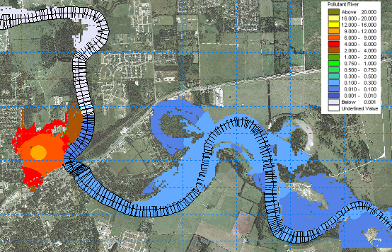 For more than a decade, MIKE FLOOD has offered complex and flexible features for coupling 1D and 2D hydrodynamic models. Flood extents and flood hazards have been some of the key issues for flood modelling. These issues will continue to be of great importance and still be focus points for many modelling applications in the future, but in addition to this, the new release of MIKE FLOOD now offers the option to simulate the transport and spreading of pollutants during a flood event through a fully dynamic coupling of the Advection Dispersion modules of MIKE 11, MIKE 21, and MIKE URBAN.
The new AD-coupling in MIKE FLOOD enables users to simulate new interesting aspects such as: -
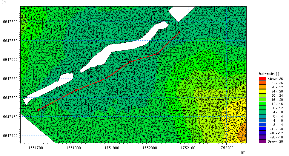 A new dike structure option has been implemented in the Flexible Mesh series of MIKE 21 and MIKE 3. Dike structures are defined by structure specific data parameters as well as location and geometry. The location in the horizontal domain is given by two or more geo-reference points (a polyline), which defines the width of the structure perpendicular to the flow direction. Each point in the polyline should be given a crest level, and it is therefore possible to obtain a spatial variation of crest elevations along a dike structure within the model domain.
Dike structures are generally used to describe local flow obstructions or other special topographical features, which are not included in the model bathymetry, and as such a highly useful feature for both coastal and inland applications. The discharge over a section covered by the dike is calculated using a standard weir expression.
MIKE SHE: Frozen soil
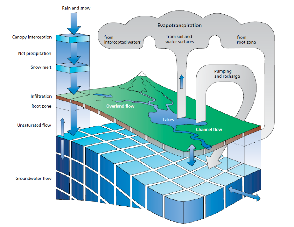 The 2012 release of MIKE SHE will contain a range of new improvements. Among these are the improvements in simulation of the annual variation of soil infiltration capacity due to freezing and thawing dynamics.
A simplified approach has been implemented, which allows the user to define a time-varying OL-UZ (Overland to Unsaturated Zone) leakage coefficient, and thereby enables the user to control the balance between infiltration and direct runoff from precipitation during all seasons of the year.
.
We are gradually approaching the release of the MIKE by DHI software package 2012, which is scheduled for this October. As in previous issues of our newsletter, we would like to disclose a preview of the many new and exciting features, which we hope will improve your experience when using the software products, both with regard to usability, productivity, and enhanced applications.
MIKE FLOOD AD: fully dynamic AD-coupling
Release 2012 introduces a fully dynamic AD-coupling in MIKE FLOOD, which increases the range of applications substantially.
The new AD-coupling in MIKE FLOOD enables users to simulate new interesting aspects such as: -
- floodplain contamination from polluted rivers
- impact assessment on river quality from pollutant sources in flood prone areas during flood events
- the impact on concentrations of river pollutant in case of a release from an urban Combined Sewer Overflow
Dike structures are generally used to describe local flow obstructions or other special topographical features, which are not included in the model bathymetry, and as such a highly useful feature for both coastal and inland applications. The discharge over a section covered by the dike is calculated using a standard weir expression.
MIKE SHE: Frozen soil
A simplified approach has been implemented, which allows the user to define a time-varying OL-UZ (Overland to Unsaturated Zone) leakage coefficient, and thereby enables the user to control the balance between infiltration and direct runoff from precipitation during all seasons of the year.
.
Thursday, 19 July 2012
WFD Modelling with MIKE FLOOD AD (Coming soon...)
Breach Modelling Tools Available within MIKE 11, MIKE 21 and MIKE FLOOD
.
Breach Modelling Tools Available within MIKE 11, MIKE 21 and MIKE FLOOD
.
Friday, 6 July 2012
Previews of MIKE by DHI Release 2012
As in previous issues of our newsletter, we would like to disclose some previews of the upcoming MIKE by DHI software package 2012, which is scheduled to be released this September. The release will contain various new and exciting features, which we hope will improve your experience when using the software products, both with regard to usability, productivity, and enhanced applications.
MIKE 21: Rating curve boundary option in 2D overland flow models
Release 2012 introduces a new rating curve boundary option in MIKE 21.
Rating curves are relationships between water levels and discharges at a given boundary location and the calculation in MIKE 21 using rating curves therefore varies the calculated level at a boundary location in response to the outflowing discharge at that location. This functionality is new compared to existing options for defining boundaries in MIKE 21, where typically fixed or time varying values are applied for a state variable like water levels or flux. A similar Qh-boundary option has been available in MIKE 11 for a long time, and now becomes available with identical numerical functionality in all of the MIKE 21 engines (Rectilinear, Flexible Mesh, and Curvilinear) as well.
This new feature is particularly interesting for inland flood modelling, where boundary locations quite often do not have any recorded water level data. Instead, the relationship between level and discharge at the boundary location can be established and defined in MIKE 21 to allow for an alternative and flexible boundary option. Rating curves in MIKE 21 for boundary conditions are defined and saved in dfs0-files as illustrated below.
Click on the image to enlarge.

MIKE 11: Improvement of MIKE 11 mapping
A 2D-mapping feature has been available in several releases of MIKE 11 and used for generating 2D maps from either stand-alone MIKE 11 simulations or as a mapping feature for combined 2D and 1D results when running a coupled (MIKE FLOOD) simulation.
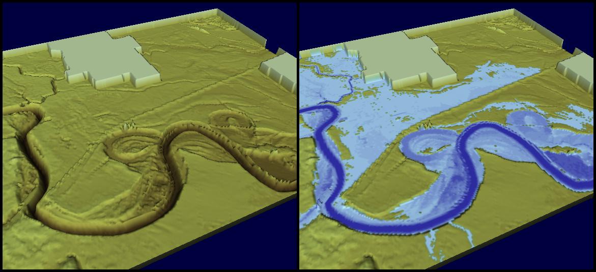
Feature improvements for outputs of 2D maps produced from combined 1D and 2D simulations are implemented in Release 2012. Primarily, bathymetry files combining both the surface and river topography can be made on-the-fly without any previously needed additional processing, but result files content from combined 2D and 1D simulations for e.g. flood mapping are also adjusted for improved results presenting and animations capability. The illustration below presents the combined 2D and 1D bathymetry at the left and a combined flood map result on the right side.
Click on the image to enlarge.
As in previous issues of our newsletter, we would like to disclose some previews of the upcoming MIKE by DHI software package 2012, which is scheduled to be released this September. The release will contain various new and exciting features, which we hope will improve your experience when using the software products, both with regard to usability, productivity, and enhanced applications.
MIKE 21: Rating curve boundary option in 2D overland flow models
Release 2012 introduces a new rating curve boundary option in MIKE 21.
Rating curves are relationships between water levels and discharges at a given boundary location and the calculation in MIKE 21 using rating curves therefore varies the calculated level at a boundary location in response to the outflowing discharge at that location. This functionality is new compared to existing options for defining boundaries in MIKE 21, where typically fixed or time varying values are applied for a state variable like water levels or flux. A similar Qh-boundary option has been available in MIKE 11 for a long time, and now becomes available with identical numerical functionality in all of the MIKE 21 engines (Rectilinear, Flexible Mesh, and Curvilinear) as well.
This new feature is particularly interesting for inland flood modelling, where boundary locations quite often do not have any recorded water level data. Instead, the relationship between level and discharge at the boundary location can be established and defined in MIKE 21 to allow for an alternative and flexible boundary option. Rating curves in MIKE 21 for boundary conditions are defined and saved in dfs0-files as illustrated below.
Click on the image to enlarge.
MIKE 11: Improvement of MIKE 11 mapping
A 2D-mapping feature has been available in several releases of MIKE 11 and used for generating 2D maps from either stand-alone MIKE 11 simulations or as a mapping feature for combined 2D and 1D results when running a coupled (MIKE FLOOD) simulation.
Feature improvements for outputs of 2D maps produced from combined 1D and 2D simulations are implemented in Release 2012. Primarily, bathymetry files combining both the surface and river topography can be made on-the-fly without any previously needed additional processing, but result files content from combined 2D and 1D simulations for e.g. flood mapping are also adjusted for improved results presenting and animations capability. The illustration below presents the combined 2D and 1D bathymetry at the left and a combined flood map result on the right side.
Click on the image to enlarge.
Subscribe to:
Posts
(Atom)
Follow DHI...


