Showing posts with label LITPACK. Show all posts
Showing posts with label LITPACK. Show all posts
Tuesday, 12 August 2014
Teaching and research with MIKE by DHI - Dr Björn Elsäßer (Queen’s University Belfast)
Presented at the 2014 MIKE by DHI UK Symposium on 13th to 14th May 2014.
Presented at the 2014 MIKE by DHI UK Symposium on 13th to 14th May 2014.
Friday, 20 December 2013
Local Flash Flood warning System
Our Local Flash Flood Warning System uses a combination of data processing, modelling and communication tools to give you the timely and accurate forecasts required to aid in proper decision making. It considers the catchment area as a whole – including flood plain and tributaries – thereby providing a more integrated, flexible and holistic approach to forecasting flash floods.
Conventional flood warning systems mainly focus on discharge predictions in the main rivers. However, local floods in smaller streams and tributaries (not generally covered by conventional warning systems) may cause a large amount of damage – particularly in urban areas.
Our Local Flash Flood Warning System overcomes this challenge by considering the entire catchment area as a whole. The system is based on existing and newly developed components of our MIKE CUSTOMISED by DHI framework. It effectively utilises a large variety of input data, sophisticated mathematical models, and advanced hydrological analysis processes.
Some of the key benefits of the system: -
Detailed sediment transport description from our two-dimensional (2D) coastal model, combined with a shoreline evolution model can help to effectively predict long-term shoreline movements. Our solution can thereby enable long-term forecasts of impacts of coastal structures on coastal processes and thereby help maintain integrity of the coastline.
Valid predictions of long-term shoreline movements are vital to mitigate or prepare for erosion and changes in coastal stability. Our new shoreline model introduces the concept of a 1-line model for shoreline evolution within the MIKE 21 FM framework. The model can be applied to problems over a longer time scale. This is due to the simplifications imposed on the morphologic evolution of the coastal profile, when compared with the existing two-dimensional (2D) morphological model MIKE 21 Coupled FM.
Some of the key benefits of the new shoreline model: -
At DHI, our advanced modelling techniques and environmental and hydrodynamic expertise can help you identify optimal sites for aquaculture production. Our innovative solution combines our knowledge of chemical and biological conditions with the three-dimensional (3D) hydrodynamic modelling of our MIKE by DHI software.
The selection of suitable sites for marine aquaculture is essential for economically viable production. Different environmental requirements, such as light, nutrients, oxygen and water column stratification, must be taken into account, during such site selections.
With our 3D MIKE model and extensive knowledge, we can help you identify the best areas for optimal aquaculture production throughout the year. We can also calculate and quantify potential disease dispersal, helping you identify more safe places for future aquacultures location. Moreover our site selection tools can aid you in selecting sites with high dilution capacities to ensure that medical products and copper do not exceed the maximum allowable concentration.
 |
| Read more >>> |
Conventional flood warning systems mainly focus on discharge predictions in the main rivers. However, local floods in smaller streams and tributaries (not generally covered by conventional warning systems) may cause a large amount of damage – particularly in urban areas.
Our Local Flash Flood Warning System overcomes this challenge by considering the entire catchment area as a whole. The system is based on existing and newly developed components of our MIKE CUSTOMISED by DHI framework. It effectively utilises a large variety of input data, sophisticated mathematical models, and advanced hydrological analysis processes.
Some of the key benefits of the system: -
- Ability to effectively forecast local flash floods by covering the entire catchment area
- Frequent forecast updates appropriate for local dynamic rainfall events and storms
- Flexibility in terms of connecting to data sources
 |
| Read more >>> |
Valid predictions of long-term shoreline movements are vital to mitigate or prepare for erosion and changes in coastal stability. Our new shoreline model introduces the concept of a 1-line model for shoreline evolution within the MIKE 21 FM framework. The model can be applied to problems over a longer time scale. This is due to the simplifications imposed on the morphologic evolution of the coastal profile, when compared with the existing two-dimensional (2D) morphological model MIKE 21 Coupled FM.
Some of the key benefits of the new shoreline model: -
- Ability to calculate stable shoreline and shoreline envelopes and compare shoreline movements for different scenarios
- Inherent inclusion of the effects of coastal structures in the shoreline model
- Ability to make long-term predictions of coastal structure interactions and their impact on coastal processes
- Maintenance of coastal profile integrity
 |
| Read more >>> |
The selection of suitable sites for marine aquaculture is essential for economically viable production. Different environmental requirements, such as light, nutrients, oxygen and water column stratification, must be taken into account, during such site selections.
With our 3D MIKE model and extensive knowledge, we can help you identify the best areas for optimal aquaculture production throughout the year. We can also calculate and quantify potential disease dispersal, helping you identify more safe places for future aquacultures location. Moreover our site selection tools can aid you in selecting sites with high dilution capacities to ensure that medical products and copper do not exceed the maximum allowable concentration.
Wednesday, 15 February 2012
Previews of MIKE by DHI 2012 Release
In the coming issues of our MIKE by DHI NetWork newsletter, we would like to disclose some previews of the new MIKE by DHI software package 2012, which is scheduled to be released this summer. The release will contain various new and exciting features, which we hope will improve your experience when using the software products, both with regard to usability, productivity, and enhanced applications.
Improvements for MIKE Animator in development
In 2012, MIKE Animator is to be replaced with MIKE Animator Plus. Compared to the existing MIKE Animator the new MIKE Animator Plus will offer an extended set of features. The most important of these new scheduled features are be:
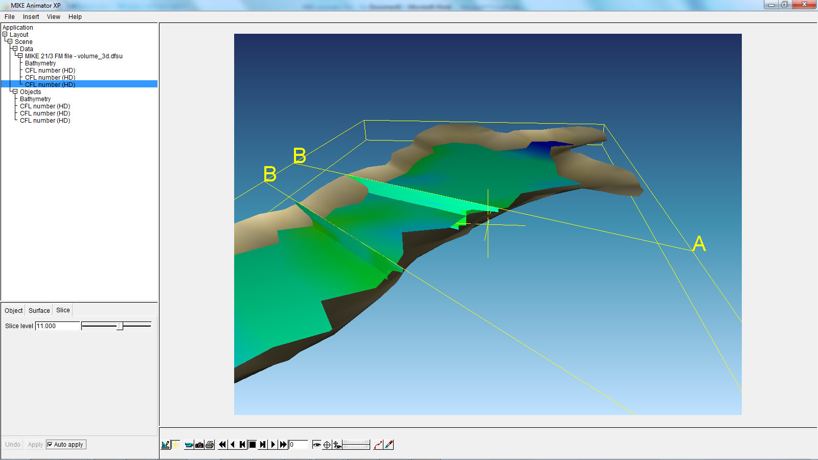
The above example shows a MIKE 3 Flexible Mesh result file with two vertical and one horizontal slice. This new feature will allow the user to get a much better overview of large 3-dimensional result files than ever before.
Littoral Processes FM: Re-design and development of LITPACK
In version 2011, the first step of the re-design of LITPACK was released, including the modules LITSTP and LITDRIFT. In the scheduled release for 2012, this re-design continues and includes the functionalities included in LITLINE.
The redesign constitutes an important milestone in the development of the system with regard to improved usability and integration into the coupled FM modelling system. The most obvious changes include the new user interface, which have the same look and feel as the rest of the MIKE Zero based products, including MIKE 21. Also the file formats have been changed. There will be one common set-up (pfs) file for all LITPACK-modules and the consequent use of standardised dfs-file formats has made it possible to introduce a higher flexibility when defining input- and output data. In this sense, one of the improvements included in the release in 2012 is the ability to work with an unlimited number of wave climates along the coastline, defined in a dfs1-file. Furthermore, all data in Littoral Processes FM will be geo-referenced, something which also makes it possible to display data in a graphic, geo-referenced view.
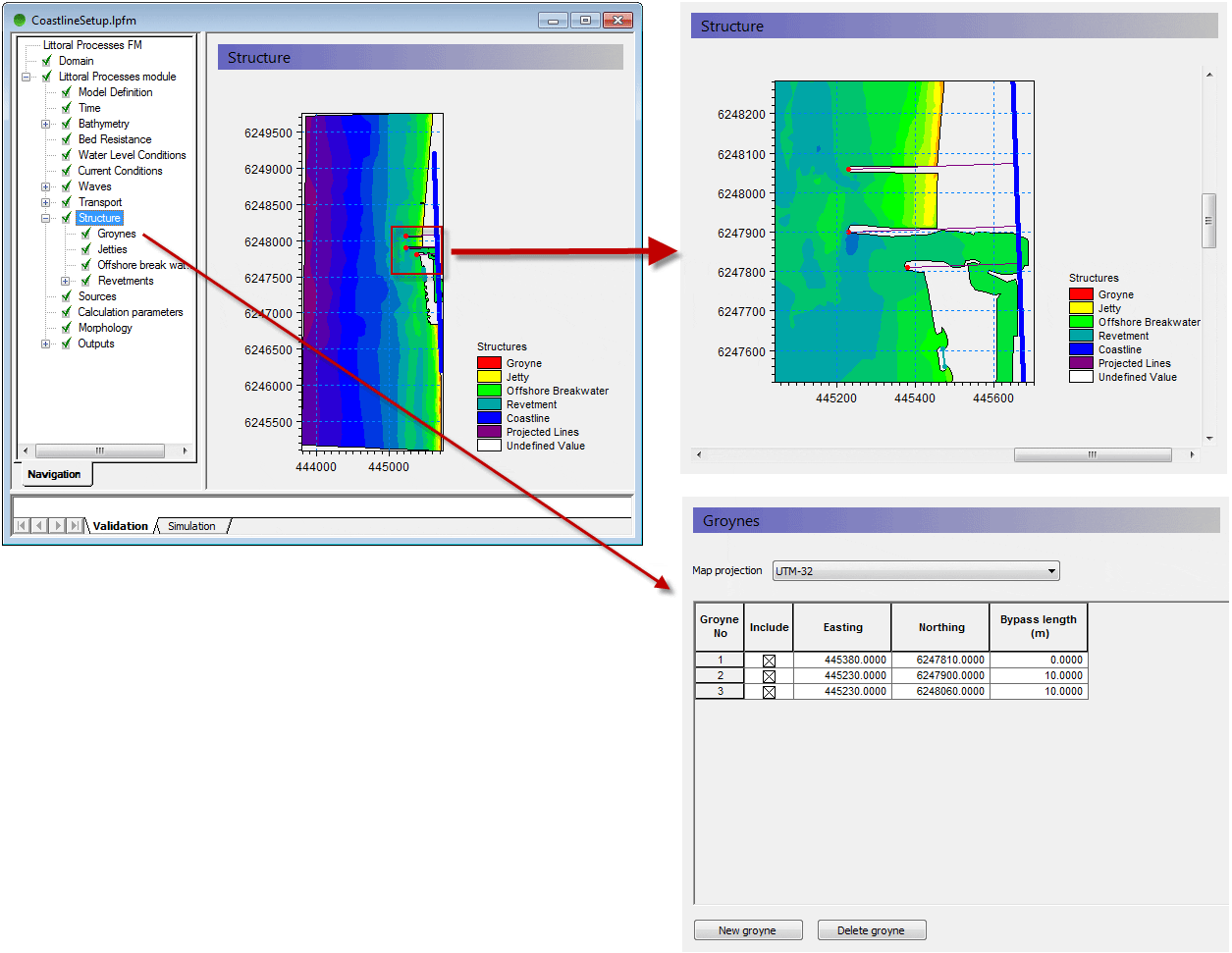
The above example shows the geographic positioning of groyne structures, with a mesh file shown as background.
Behind the scenes of MIKE URBAN 2012
Also MIKE URBAN users will notice improvements in 2012, where the new MIKE URBAN will transform the way people use hydraulic software. Be more productive and take advantage of the new, scheduled processing features of MIKE URBAN.
Currently our developers work hard to implement calibration plots and reports inside MIKE URBAN. This functionality will support plots of measured and simulated data. MIKE URBAN users will benefit from the possibility to generate series of calibration plots showing corresponding values of measured and simulated data along with comparison statistics in a tabular form. Find out more about other features of MIKE URBAN in one of our next newsletters.
In the coming issues of our MIKE by DHI NetWork newsletter, we would like to disclose some previews of the new MIKE by DHI software package 2012, which is scheduled to be released this summer. The release will contain various new and exciting features, which we hope will improve your experience when using the software products, both with regard to usability, productivity, and enhanced applications.
Improvements for MIKE Animator in development
In 2012, MIKE Animator is to be replaced with MIKE Animator Plus. Compared to the existing MIKE Animator the new MIKE Animator Plus will offer an extended set of features. The most important of these new scheduled features are be:
- Support for MIKE 3 Flexible Mesh result files - including vertical and horizontal slices, sigma layered slices and isosurfaces.
- Support for MIKE 3 Classic result files - including vertical and horizontal slices, sigma layered slices and isosurfaces.
- Extended image draping – meaning that multiple geo-referenced images can be rectified online and draped onto selected surfaces
- Import of solids – solids can be buildings, dams or other types of structures.
The above example shows a MIKE 3 Flexible Mesh result file with two vertical and one horizontal slice. This new feature will allow the user to get a much better overview of large 3-dimensional result files than ever before.
Littoral Processes FM: Re-design and development of LITPACK
In version 2011, the first step of the re-design of LITPACK was released, including the modules LITSTP and LITDRIFT. In the scheduled release for 2012, this re-design continues and includes the functionalities included in LITLINE.
The redesign constitutes an important milestone in the development of the system with regard to improved usability and integration into the coupled FM modelling system. The most obvious changes include the new user interface, which have the same look and feel as the rest of the MIKE Zero based products, including MIKE 21. Also the file formats have been changed. There will be one common set-up (pfs) file for all LITPACK-modules and the consequent use of standardised dfs-file formats has made it possible to introduce a higher flexibility when defining input- and output data. In this sense, one of the improvements included in the release in 2012 is the ability to work with an unlimited number of wave climates along the coastline, defined in a dfs1-file. Furthermore, all data in Littoral Processes FM will be geo-referenced, something which also makes it possible to display data in a graphic, geo-referenced view.
The above example shows the geographic positioning of groyne structures, with a mesh file shown as background.
Behind the scenes of MIKE URBAN 2012
Also MIKE URBAN users will notice improvements in 2012, where the new MIKE URBAN will transform the way people use hydraulic software. Be more productive and take advantage of the new, scheduled processing features of MIKE URBAN.
Currently our developers work hard to implement calibration plots and reports inside MIKE URBAN. This functionality will support plots of measured and simulated data. MIKE URBAN users will benefit from the possibility to generate series of calibration plots showing corresponding values of measured and simulated data along with comparison statistics in a tabular form. Find out more about other features of MIKE URBAN in one of our next newsletters.
Thursday, 20 January 2011
Coast & Sea
LITPACK Redesign
Release 2011 includes a complete redesign of LITPACK, the modelling package for coastal sediment transport and morphology. The redesign includes:
The redesign is a step towards integration in the coupled MIKE 21 FM.
Cyclone Tool
The MIKE 21 toolbox includes a tool for computing wind and pressure fields generated by a cyclone, hurricane or typhoon.
The old Cyclone Tool uses a parametric model developed in the early 1980s that in some cases overpredicts winds.
In Release 2011, several newer parametric models of the cyclone process have been added.
MIKE 21 SW
The Spectral Wave module includes numerous improvements:
MIKE 21/3 FM Improvements
Apart from the significant speed improvements, several other new features are included in Release 2011:
Particle Tracking and New Oil Spill in FM
Release 2011 also includes an improved Particle Tracking module for the FM series. The module includes added features and larger flexibility in terms of output and functionality.
Now the FM series also includes an oil spill module with the same backbone as the Particle Tracking module.
Mesh Generator Enhancements
The new version of the Mesh Generator tool includes several major enhancements including:
LITPACK Redesign
Release 2011 includes a complete redesign of LITPACK, the modelling package for coastal sediment transport and morphology. The redesign includes:
- A new user interface
- Common setup file for all LITPACK modules
- Flexible definition of input values (constant/time varying/spatially varying)
- User specification of output parameters
- Graphical view of setup in georeferenced domain
- Additional functionality, e.g. calculation of Q-Alpha curves
- Improved Rose Plot: 3rd item defines duration of event
- Improved Profile Editor: Georeferenced line series data
- Improved Project Map: Line series display included
The redesign is a step towards integration in the coupled MIKE 21 FM.
Cyclone Tool
The MIKE 21 toolbox includes a tool for computing wind and pressure fields generated by a cyclone, hurricane or typhoon.
The old Cyclone Tool uses a parametric model developed in the early 1980s that in some cases overpredicts winds.
In Release 2011, several newer parametric models of the cyclone process have been added.
MIKE 21 SW
The Spectral Wave module includes numerous improvements:
- Significant performance improvement by domain decomposition
- Improved convergence of quasi-steady component
- Output of wave power
- Improved description of structures
MIKE 21/3 FM Improvements
Apart from the significant speed improvements, several other new features are included in Release 2011:
- Dynamic update of bathymetries (for dam/dune breaks, morphological seabed changes)
- Improved description of velocity profiles in river simulations
Particle Tracking and New Oil Spill in FM
Release 2011 also includes an improved Particle Tracking module for the FM series. The module includes added features and larger flexibility in terms of output and functionality.
Now the FM series also includes an oil spill module with the same backbone as the Particle Tracking module.
Mesh Generator Enhancements
The new version of the Mesh Generator tool includes several major enhancements including:
- Handling of large scatter data,
- Performance improvement for editing and interpolation in large scatter data sets, and
- Prioritisation of scatter data
Subscribe to:
Posts
(Atom)
Follow DHI...


