Sunday, 19 February 2012

We are looking forward to welcoming you to our Spring 2012 User Group Meeting on the 20th of March 2012, and Seminar Day on 21st of March 2012, at the Lion Quays Waterside Resort, Oswestry, UK.
The User Group Meeting will include a mixture of presentations of forthcoming software features and technologies, as well as practical case studies and papers presented by UK users.
2012 MIKE by DHI UK User Group Meeting: Proposed Agenda
Tuesday 20th March 2012
The User Group Meeting will cover the follow topics: MIKE Marine Modelling including WQ & Wave Modelling, Urban Flood Routeing & Hazard Mapping, Water Resources including Channel and Reservoir Flood Modelling & Catchment Integration, and Ground Water Quality & Artificial Re-charge Modelling. The following presentations are confirmed: -
For a taster of Grantley Smith's presentation, please see the video below or read this news article: http://www.nbnnews.com.au/index.php/2012/02/09/pasha-bulker-storm-changes-the-way-we-plan-for-floods/.
- Urban Flood Flows (Grantley Smith, University of Newcastle, NSW)
- Reservoir Discontinuance and River Restoration using MIKE 21 FMST (MWH)
- Wave Modelling with MIKE 21 BW & SW, and Cliff Recession Review (Mott MacDonald)
- Aquifer storage and recovery in a confined UK aquifer (ESI)
- Integrated Catchment Management with MIKE BASIN (JBA)
- Maritime Archaeological Modelling using MIKE 21 (Southampton University)
The suburb of Merewether in Newcastle is providing engineers with critical data that will inform emergency personnel on how to plan better for the floods which have wreaked havoc across Australia in the past few years. A model of the suburb has been created in Sydney's Water Research Lab.
Wednesday 21st March 2012
It is envisaged that the proposed Training Seminars will cover the follow topics: -
- Urban Flood: Why DHI is the largest supplier of Urban Water modelling software in the world...
- Water Resources: 1D / 2D Integrated Flood & Water Quality
- Ground Water: An Introduction to 3D Visualisation using FEFLOW
The above 1-day course on Shoreline Management will include an overview and discussion of the following topics: -
- Shoreline Management: How to Protect and Develop your Coasts
The free 1-day Shoreline Management course is a shortened version of a comprehensive 4-day training course, if you are interested in the full course please contact us.
- Introducing coastal and estuarine processes (physics)
- Understanding sources of shoreline impact (anthropological effects)
- Accounting for future variations in environmental conditions (climate change & policy)
- Fitting the complexity of the modelling to the level of the study (regulator response)
More information will follow soon.

Online booking is now available via www.mikebydhi.com/Events/UKUGM2012, so get your name on the most sought after list of the year so far!
If you would like more information about the content of the event please contact: -
- Simon Matthews on 01694 722795 or sm@dhigroup.com
- Steve Flood on 01752 691723 or sjf@dhigroup.com
Wednesday, 15 February 2012
Previews of MIKE by DHI 2012 Release
In the coming issues of our MIKE by DHI NetWork newsletter, we would like to disclose some previews of the new MIKE by DHI software package 2012, which is scheduled to be released this summer. The release will contain various new and exciting features, which we hope will improve your experience when using the software products, both with regard to usability, productivity, and enhanced applications.
Improvements for MIKE Animator in development
In 2012, MIKE Animator is to be replaced with MIKE Animator Plus. Compared to the existing MIKE Animator the new MIKE Animator Plus will offer an extended set of features. The most important of these new scheduled features are be:
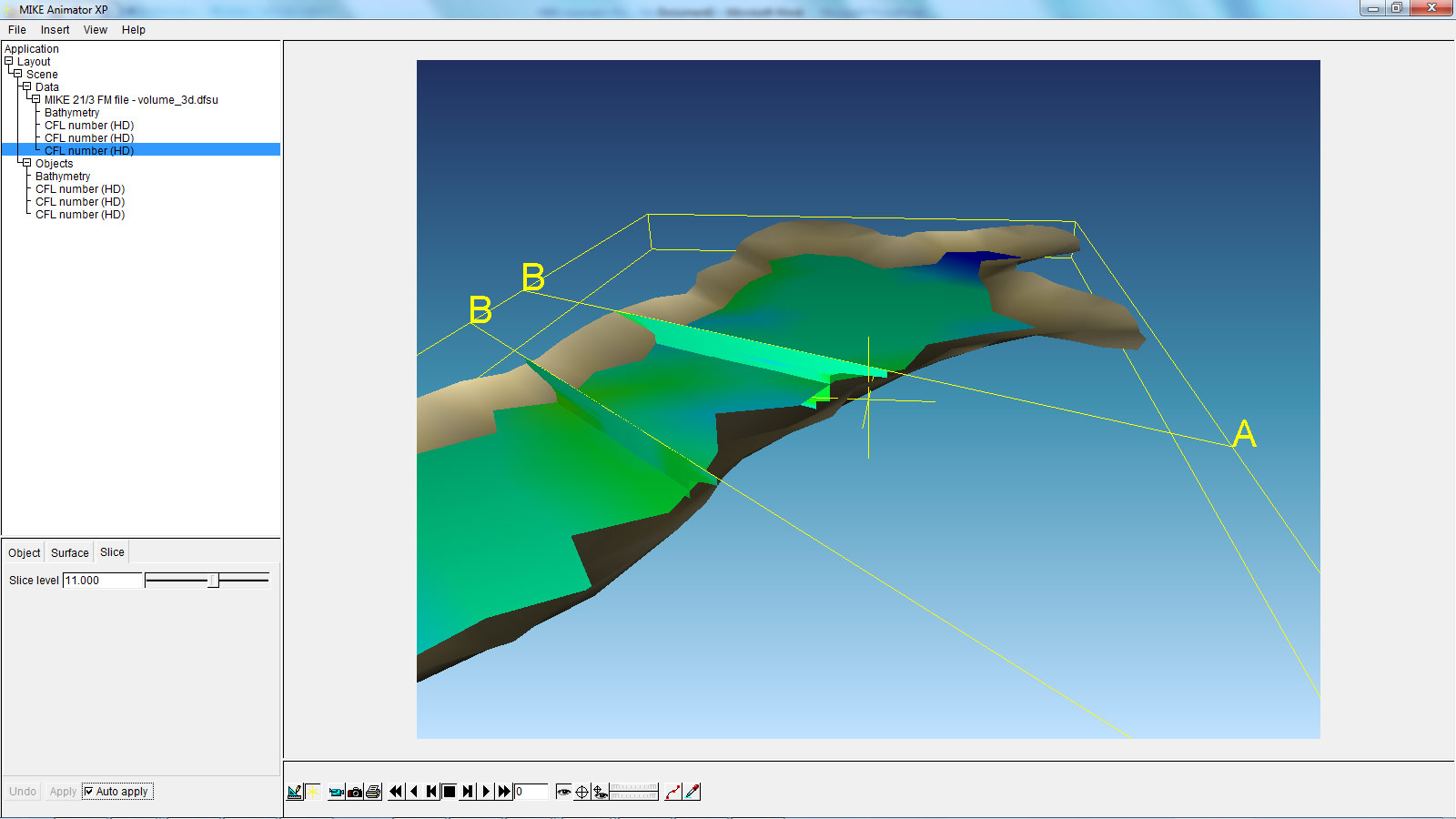
The above example shows a MIKE 3 Flexible Mesh result file with two vertical and one horizontal slice. This new feature will allow the user to get a much better overview of large 3-dimensional result files than ever before.
Littoral Processes FM: Re-design and development of LITPACK
In version 2011, the first step of the re-design of LITPACK was released, including the modules LITSTP and LITDRIFT. In the scheduled release for 2012, this re-design continues and includes the functionalities included in LITLINE.
The redesign constitutes an important milestone in the development of the system with regard to improved usability and integration into the coupled FM modelling system. The most obvious changes include the new user interface, which have the same look and feel as the rest of the MIKE Zero based products, including MIKE 21. Also the file formats have been changed. There will be one common set-up (pfs) file for all LITPACK-modules and the consequent use of standardised dfs-file formats has made it possible to introduce a higher flexibility when defining input- and output data. In this sense, one of the improvements included in the release in 2012 is the ability to work with an unlimited number of wave climates along the coastline, defined in a dfs1-file. Furthermore, all data in Littoral Processes FM will be geo-referenced, something which also makes it possible to display data in a graphic, geo-referenced view.
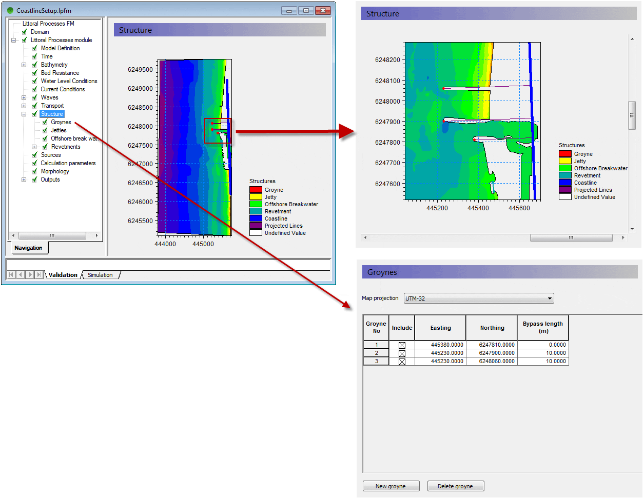
The above example shows the geographic positioning of groyne structures, with a mesh file shown as background.
Behind the scenes of MIKE URBAN 2012
Also MIKE URBAN users will notice improvements in 2012, where the new MIKE URBAN will transform the way people use hydraulic software. Be more productive and take advantage of the new, scheduled processing features of MIKE URBAN.
Currently our developers work hard to implement calibration plots and reports inside MIKE URBAN. This functionality will support plots of measured and simulated data. MIKE URBAN users will benefit from the possibility to generate series of calibration plots showing corresponding values of measured and simulated data along with comparison statistics in a tabular form. Find out more about other features of MIKE URBAN in one of our next newsletters.
In the coming issues of our MIKE by DHI NetWork newsletter, we would like to disclose some previews of the new MIKE by DHI software package 2012, which is scheduled to be released this summer. The release will contain various new and exciting features, which we hope will improve your experience when using the software products, both with regard to usability, productivity, and enhanced applications.
Improvements for MIKE Animator in development
In 2012, MIKE Animator is to be replaced with MIKE Animator Plus. Compared to the existing MIKE Animator the new MIKE Animator Plus will offer an extended set of features. The most important of these new scheduled features are be:
- Support for MIKE 3 Flexible Mesh result files - including vertical and horizontal slices, sigma layered slices and isosurfaces.
- Support for MIKE 3 Classic result files - including vertical and horizontal slices, sigma layered slices and isosurfaces.
- Extended image draping – meaning that multiple geo-referenced images can be rectified online and draped onto selected surfaces
- Import of solids – solids can be buildings, dams or other types of structures.
The above example shows a MIKE 3 Flexible Mesh result file with two vertical and one horizontal slice. This new feature will allow the user to get a much better overview of large 3-dimensional result files than ever before.
Littoral Processes FM: Re-design and development of LITPACK
In version 2011, the first step of the re-design of LITPACK was released, including the modules LITSTP and LITDRIFT. In the scheduled release for 2012, this re-design continues and includes the functionalities included in LITLINE.
The redesign constitutes an important milestone in the development of the system with regard to improved usability and integration into the coupled FM modelling system. The most obvious changes include the new user interface, which have the same look and feel as the rest of the MIKE Zero based products, including MIKE 21. Also the file formats have been changed. There will be one common set-up (pfs) file for all LITPACK-modules and the consequent use of standardised dfs-file formats has made it possible to introduce a higher flexibility when defining input- and output data. In this sense, one of the improvements included in the release in 2012 is the ability to work with an unlimited number of wave climates along the coastline, defined in a dfs1-file. Furthermore, all data in Littoral Processes FM will be geo-referenced, something which also makes it possible to display data in a graphic, geo-referenced view.
The above example shows the geographic positioning of groyne structures, with a mesh file shown as background.
Behind the scenes of MIKE URBAN 2012
Also MIKE URBAN users will notice improvements in 2012, where the new MIKE URBAN will transform the way people use hydraulic software. Be more productive and take advantage of the new, scheduled processing features of MIKE URBAN.
Currently our developers work hard to implement calibration plots and reports inside MIKE URBAN. This functionality will support plots of measured and simulated data. MIKE URBAN users will benefit from the possibility to generate series of calibration plots showing corresponding values of measured and simulated data along with comparison statistics in a tabular form. Find out more about other features of MIKE URBAN in one of our next newsletters.

The latest MIKE by DHI NetWork newsletter has been published, and selected articles are presented below: -
Product News
- MIKE by DHI ISO 9001 certification: We are proud to announce that DNV has granted DHI the official "ISO 9001: Quality Management Systems" certificate. "Consistent, high quality of not only our software development processes but of the entire user experience with the MIKE products is our single highest priority" says Jørgen Bo Nielsen, Managing Director of the MIKE by DHI global business. Click here to read more about the ISO 9001 certification or click here to read more about it in our latest newsletter.
- MIKE by DHI in the CLOUD: Meet your deadlines without buying more hardware or software. You can now get easy access to more licenses and more hardware through the new MIKE by DHI Software as a Service (SaaS) Portal. Get started with MIKE in the cloud now! Click here to go to the MIKE by DHI SaaS Portal or click here to read more in our latest newsletter.
- Study in Florida accomplishes reduction in dredging frequency: The Matanzas Inlet in Florida and an Intracoastal Waterway close to the inlet were challenged with high waves and high levels of shoaling. This was due to a close proximity to a natural sandy inlet, causing sediment transport into the Intracoastal Waterway. The challenge of high maintenance requirements of the Matanzas Inlet in Florida has caused the Florida Inland Navigation District to initiate a study to investigate the inlet area and examine alternatives to reduce the sediment inflow into the waterways. The study was performed by Taylor engineering and a coastal model was developed using MIKE21. With concerns to the estimated construction and maintenance cost, a deep sediment basin was chosen, from several alternative solutions, which would reduce dredging frequency in the Intracoastal Waterway to one dredging operation every four years as opposed to the previous average of 2.7 years. Read more here.
- Floating breakwater reduces wave heights in tugboat port in Germany: In one of the major ports, Jade Weser Port, in northern Germany the construction of a temporary tugboat port was challenged by high waves of up to 0.8 m for a mean water level of +3.00 m NN within the port. This was caused by an exposed location of the port affected by primarily eastern and northern winds. A study was conducted for client, Inros Lackner, in order to discover ways of reducing the impact of the winds within the port area using a MIKE 21 Boussinesq wave model (BW). The study determined the actual height of the waves and a simulation of the possible reduction was made. The reached solution became a floating breakwater within the port that would reduce the wave heights of about 10–30 pct. With the combination of expert consultancy and high quality software, they were able to reach a solution that was inexpensive, fairly easy to install, and with great result for the client. For more information, read here or please contact Oliver Stoschek or Anja Brüning.
- New insight into Bull Sharks' behaviour in Australia using individual-based modelling: Studying fish, sharks, and other marine mammals is often a challenge due to lack of accurate information that provides a realistic portrait of their living conditions, movements, and the elements that affect their behaviour. Researchers at Griffith University in Queensland in Australia have recently successfully employed an individual-based modelling technique to investigate the habitat and movement patterns of juvenile bull sharks in the Tallebudgera Creek estuary in Australia. The modelling tools in MIKE21 and ECO Lab were used to accurately capture the hydrodynamics of the estuary to create a virtual habitat and integrate tracking results of a number of juvenile bull sharks. Their work has provided new valuable knowledge and a fairly accurate picture of, which elements affect the bull sharks and their living conditions such as water quality, salinity levels, turbidity, and currents. Thus, this use of individual-based modelling paves the way for new possibilities of researching marine mammals in the future. The research project at Griffith University in Australia is a recent example of how MIKE by DHI supports universities by providing software to PHD and MSc students on very favourable conditions. For more information about individual-based modelling, please contact Michael Potthoff. For more information about the specific research on bull sharks, please contact Jonas Brandi Mortensen.
- Flood modelling enlighten community in Iowa, United States: In 2008, the state of Iowa in the United States experienced severe flooding, where many property owners and entire communities suffered. Since then, Iowa Flood Center (IFC) has used MIKE FLOOD modelling of the severe 2008 floods for community outreach and education. "The Iowa Flood Center (IFC), a state-funded center comprised of IIHR–Hydroscience & Engineering researchers, has been using MIKE FLOOD to simulate flood discharges in several Iowa communities. The simulations have been used to numerically reconstruct the severe 2008 Iowa floods and to develop libraries of static inundation maps relating river stage and discharge to flood extents and depths in each community. The intent is to provide communities and individuals an impression of how river stages and discharges forecasted at discrete points may affect their properties." Nathan C Young, Associate Director, Iowa Flood Center. Read more here. The maps are available on the IFC website as part of the Iowa Flood Information System (IFIS).
- Focused mitigation of hazardous urban discharges: Comprehensive monitoring and modelling of discharges of hazardous substances in the Copenhagen Harbour district revealed the most important point sources of selected substances and thereby allows for a sensible and target-oriented prioritisation of future mitigation measures. The present study determined whether or not specific point sources (e.g. wastewater treatment plants, industries or combined sewer overflow) release significant emissions of hazardous substances as listed in the Baltic Sea Action Plan. It was carried out within the framework of the EU-funded COHIBA-project (Control of Hazardous Substances in the Baltic Sea Region) as a combination of wastewater measurements, load estimations and modelling of the discharges (hydrodynamic marine fate modelling with MIKE 3 and ECOlab). Read more.
| Hydrodynamic fate modelling of Bisphenol A in Copenhagen Harbour. The animation shows the modelled discharge, spreading and fate of Bisphenol A after heavy rain, which results in combined sewer overflows. Moreover, industrial discharges are modelled. The model takes into account substance specific fate data (biodegradation, photolysis and hydrolysis) as well as adsorption to suspended solids. |
The newsletter can be viewed online here.
To subscribe to the newsletter(s), please visit http://www.graphicmail.com/rwcode/subscribe.aspx?SiteID=3526&Mode=subscribe
Climate Change – Adapting to the Future
Climate change will mainly hit us first through water. In order for societies to prepare for this, the global challenge is to reduce the vulnerability of natural and human systems. There is a rapidly increasing need to create adaptation actions in order to manage the effects of extreme water rainfalls, heavy storms, droughts, etc.
Together with clients and organisations worldwide DHI has for decades been developing solutions for climate change adaptation. We have now compiled our comprehensive knowledge and experiences in three Climate Change Adaptation Guidelines. They give a state-of-the-art overview and also describe in detail the methodologies to be used to achieve sustainable climate change adaptation within the areas of Water Resources, Urban and Marine.

The guideline for the urban area describes for example how flooding from the sea and from drainage systems can be countered in cities. Tools and methodologies are described and evaluated and so is the planning of flood emergency preparedness.
The marine area guideline describes the climate change impacts on water levels, waves and temperature. You get methodologies for preparing marine infrastructure projects and for developing sustainable solutions for harbours and coastal cities.
It is vital for the future survival of many societies e.g. in Africa to achieve sustainable climate change adaptation within water resources. But how can one evaluate the impact from various CO2 emission scenarios and transform them into impact on precipitation? This is just one of the difficult procedures described in this guideline.
Climate change guidelines for your use
The three guidelines are all available for public download. Please feel free to share them with your colleagues and friends. The guidelines can be downloaded here: -
Through this initiative, it is our wish to increase DHI’s contribution to a sustainable adaptation to climate change. For further information please contact Jacob Høst-Madsen, Consultancy Director, DHI.
Other resources
.
Climate change will mainly hit us first through water. In order for societies to prepare for this, the global challenge is to reduce the vulnerability of natural and human systems. There is a rapidly increasing need to create adaptation actions in order to manage the effects of extreme water rainfalls, heavy storms, droughts, etc.
Together with clients and organisations worldwide DHI has for decades been developing solutions for climate change adaptation. We have now compiled our comprehensive knowledge and experiences in three Climate Change Adaptation Guidelines. They give a state-of-the-art overview and also describe in detail the methodologies to be used to achieve sustainable climate change adaptation within the areas of Water Resources, Urban and Marine.
The guideline for the urban area describes for example how flooding from the sea and from drainage systems can be countered in cities. Tools and methodologies are described and evaluated and so is the planning of flood emergency preparedness.
The marine area guideline describes the climate change impacts on water levels, waves and temperature. You get methodologies for preparing marine infrastructure projects and for developing sustainable solutions for harbours and coastal cities.
It is vital for the future survival of many societies e.g. in Africa to achieve sustainable climate change adaptation within water resources. But how can one evaluate the impact from various CO2 emission scenarios and transform them into impact on precipitation? This is just one of the difficult procedures described in this guideline.
Climate change guidelines for your use
The three guidelines are all available for public download. Please feel free to share them with your colleagues and friends. The guidelines can be downloaded here: -
- Marine Climate Change Guidelines
- Water Resources Climate Change Guidelines
- Urban Climate Change Guidelines
Through this initiative, it is our wish to increase DHI’s contribution to a sustainable adaptation to climate change. For further information please contact Jacob Høst-Madsen, Consultancy Director, DHI.
Other resources
.
Subscribe to:
Comments
(Atom)
Follow DHI...


