Tuesday, 20 April 2010
Simulation of dam break flow around buildings using a high-resolution MIKE FLOOD FM (Flexible Mesh) model
Introduction
The following example is intended to augment the MIKE FLOOD Classic (SG) results presented within the forthcoming Environment Agency Science Report 'Benchmarking of 2D Hydraulic Modelling Packages'. Information on this study can currently be found in the 'Desktop Review of 2D Hydraulic Software Packages' report; available here (opens PDF document).
This dam break test has been adapted from an original benchmark test case available from the IMPACT project (IMPACT, 2004; Soares-Frazao and Zech, 2002), for which measurements from a physical laboratory model at the Civil Engineering Laboratory of the Université Catholique de Louvain (UCL) are available. The test involves a simple topography, a dam with a 1.0m wide opening, and an idealised representation of a single building downstream of the dam.

Software used
Product: MIKE FLOOD FM (Flexible Mesh)
Version: 2009 including Service Pack 3
Numerical scheme: Finite Volume (FV) [2]
Hardware used
Processor type: Intel Core 2 Quad CPU Q9450
Speed: 2.66 GHz
RAM: 4.00 GB
Model Parameters
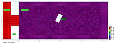
 Model bathymetry: Triangular elements have been used to improve the definition of the building as above (quadrangular elements have been used elsewhere, at an approximate grid resolution of 0.1m, particularly to improve definition of model bathymetry along the base slopes and to refine flow through the gate opening).
Time increment (s): 0.02 (adaptive 0.001 - 0.02)
Flood and Dry: Drying depth = 0.001, Flooding depth = 0.002 & Wetting depth = 0.005
Eddy viscosity (m2/s): Smagorinsky formulation (default)
Bed resistance: Manning's M = 100
 Initial conditions: Uniform depths of 0.4m upstream from the dam and 0.02m downstream from the dam.
 Boundary conditions: Flow is contained by vertical walls at all boundaries of the model domain (only a section of the full model is presented above).
Model Results
Grid resolution (m): 38053 nodes / 38690 elements
Total simulation time (s): 149
 Maximum water surface elevations reached during the simulation (m); transformed 0.05m grid resolution.
 Maximum velocities reached during the simulation (m/s); transformed 0.05m grid resolution.
 MIKE 21 Flow Model FM point series output locations.
 Plot of water surface elevation against time for all point series output locations (m)
 Plot of velocity against time for all point series output locations (m/s)

Introduction
The following example is intended to augment the MIKE FLOOD Classic (SG) results presented within the forthcoming Environment Agency Science Report 'Benchmarking of 2D Hydraulic Modelling Packages'. Information on this study can currently be found in the 'Desktop Review of 2D Hydraulic Software Packages' report; available here (opens PDF document).
This dam break test has been adapted from an original benchmark test case available from the IMPACT project (IMPACT, 2004; Soares-Frazao and Zech, 2002), for which measurements from a physical laboratory model at the Civil Engineering Laboratory of the Université Catholique de Louvain (UCL) are available. The test involves a simple topography, a dam with a 1.0m wide opening, and an idealised representation of a single building downstream of the dam.
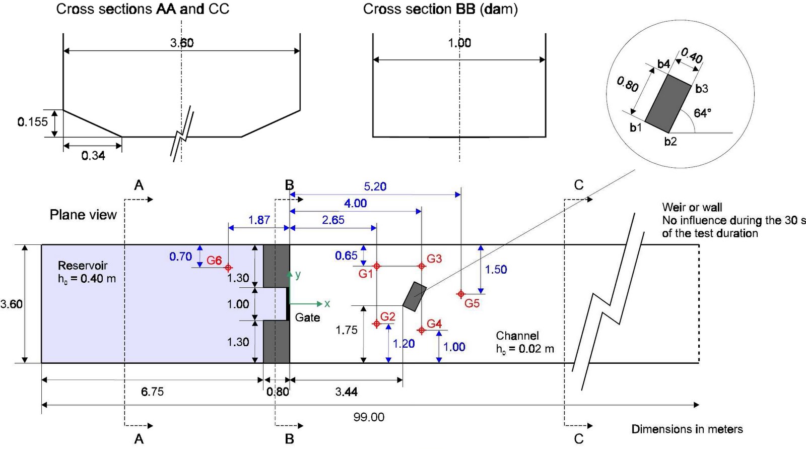
Model Set-up (adapted from Soares-Frazao and Zech, 2002).
[1] The SOARES-FRAZAO, S. AND ZECH, Y., 2002 Dam break flow experiment (Isolated building test case) is available online at http://www.impact-project.net/wp3_technical.htm
Software used
Product: MIKE FLOOD FM (Flexible Mesh)
Version: 2009 including Service Pack 3
Numerical scheme: Finite Volume (FV) [2]
Hardware used
Processor type: Intel Core 2 Quad CPU Q9450
Speed: 2.66 GHz
RAM: 4.00 GB
[2] The numerical solution of the shallow water equations (2D cases) uses an approximate Riemann solver (Roe’s scheme; Roe, 1981) to calculate the convective fluxes at the interface of the triangular and/or quadrangular cells/elements. Average gradients are estimated using the approach by Jawahar and Kamath, 2000. Numerical oscillations are avoided using a second order TVD slope limiter (Van Leer limiter; Hirch, 1990 and Darwish, 2003).
Model Parameters

Time increment (s): 0.02 (adaptive 0.001 - 0.02)
Flood and Dry: Drying depth = 0.001, Flooding depth = 0.002 & Wetting depth = 0.005
Eddy viscosity (m2/s): Smagorinsky formulation (default)
Bed resistance: Manning's M = 100


Model Results
Grid resolution (m): 38053 nodes / 38690 elements
Total simulation time (s): 149
Animation of water surface elevations in first 30-seconds of simulation (m)

Animation of velocities in first 30-seconds of simulation (m/s)


Detailed comparison of MIKE FLOOD FM modelled water surface elevations and UCL laboratory observations (click to enlarge).
Animation of water surface elevations showing development of hydraulic jump (m)
.
.
Subscribe to:
Posts
(Atom)
Follow DHI...


