Showing posts with label Flexible mesh. Show all posts
Showing posts with label Flexible mesh. Show all posts
Thursday, 5 December 2013
Marine application
3D model (MIKE 3 FMHD with MIKE 3 FMPT)
Two simultaneous releases both made at 3.0m below the water surface. The square markers are the neutrally buoyant particles (e.g. bacteriological effluent), and these are permanently deposited (i.e. not re-suspended) upon contact with the bed. The triangular markers are negatively buoyant particles that have a positive fall velocity (e.g. sand), these are allowed to re-suspend upon contact with the bed. The reduced flow speeds near the bed (from the 3D model) can be clearly seen by the movement of the sand particles. Marker colour changes to represent the vertical position of the particle.
Riverine application
2D model (MIKE 21 FMHD with MIKE 21 FMPT)
Neutrally buoyant particles released at bed level in a river with a varying flow. The trails show the previous location of the particles (for the last 3 time steps).
3D model (MIKE 3 FMHD with MIKE 3 FMPT)
Two simultaneous releases both made at 3.0m below the water surface. The square markers are the neutrally buoyant particles (e.g. bacteriological effluent), and these are permanently deposited (i.e. not re-suspended) upon contact with the bed. The triangular markers are negatively buoyant particles that have a positive fall velocity (e.g. sand), these are allowed to re-suspend upon contact with the bed. The reduced flow speeds near the bed (from the 3D model) can be clearly seen by the movement of the sand particles. Marker colour changes to represent the vertical position of the particle.
Riverine application
2D model (MIKE 21 FMHD with MIKE 21 FMPT)
Neutrally buoyant particles released at bed level in a river with a varying flow. The trails show the previous location of the particles (for the last 3 time steps).
Monday, 2 December 2013
Previews of MIKE by DHI Release 2014
Approximately once a year, we release a new version of our MIKE by DHI software - and this year is no exception. We would like to reveal herewith a preview of some of the new and exciting features to be released in December. We hope these new features will improve your experience with our software products, regarding usability, productivity as well as enhanced applications.
New possibilities of including moving objects in your animations
Ever wanted to add moving objects to your animations? This is possible with Release 2014.
In the September issue of this newsletter, we included a preview of new features in MIKE Animator Plus in Release 2014. In this issue, we would like to show you an example of the possibilities of this new development.
With MIKE Animator Plus, you can create visual animations to present you model results – and as something new, you will be able to include visualisation of solids. Through the inclusion of solids, you can improve your animations significantly by enhancing realism and recognition of locations, for example by including fixed elements like buildings and dams or moving elements like ships. Release 2014 will support the placement of solids inside the model domain and allow them to move, which means that a ship can be sailing as part of the animation.
MIKE HYDRO Basin: Global prioritisation of water users
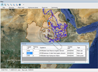 MIKE HYDRO Basin is our new generation of integrated river basin analysis software for water resources planning and management.
MIKE HYDRO Basin was introduced with the current release 2012, containing a large number of features relevant for integrated river basin management applications. Developments continue for MIKE HYDRO Basin and the new release will introduce another very interesting new feature to modellers of river basin water allocation schemes and resources management; Global Prioritisation.
With this new feature, it is now possible to include a user defined prioritisation of water users within the basin model - regardless of their geographical location within the basin. Thus, it highly increases the applicability of MIKE HYDRO Basin for specific types of water resources management applications.
The global prioritisation of water users are defined through ‘Ranking’ number definitions, where water consumers are assigned an individual ranking number. The ranking numbers are used during simulation to prioritise consumers, in case of water shortage, in order to accommodate the water demands for these - taking into account that some users have a higher priority than others.
Mesh Generation: A new tool for creating flexible meshes from dfs2 files and other sources
 The combination of high flexibility of flexible meshes (FM) and impressive performance improvements, introduced in the latest releases of MIKE by DHI, make the use of FM versions of MIKE 21, MIKE 3 and MIKE FLOOD even more attractive. Improvements in recent releases include, amongst others, the introduction of shared memory based parallelisation, porting of simulation engines to LINUX and, in Release 2014, supporting Graphical Processing Units (GPUs) for MIKE 21 HD FM.
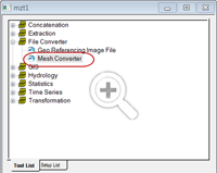
In order to assist those, who want to transfer existing models or bathymetries into the FM system, Release 2014 will contain a new tool, aimed to convert bathymetries in other formats into FM format.
The new Mesh Converter is included in the MIKE Zero Toolbox and supports DHI’s own format from the ‘classic’ modelling series, dfs2 as well as some external formats (ADCIRC, SMS, TUFLOW). The process is quick and easy and produces an equal bathymetry in FM format, which can then be modified using all the existing editing facilities of MIKE Zero’s Mesh Generator.
New features in FEFLOW 6.2
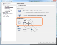 FEFLOW 6.2 offers a number of new features to enhance your groundwater modelling work.
Storage Capture/Release is a new component in the Rate Budget and Period Budget Panels for flow and transport in FEFLOW 6.2. With this new component, you can clearly separate storage change and solution error in transient models.
Increased performance with new MIKE 1D features in MIKE URBAN
Strengthening wastewater modelling projects with new features in WEST 2014
We are also pleased to inform you that Release 2014 of WEST will include a plant wide model (PWM) for simulating nutrient removal activated sludge systems.
The plant wide model is developed jointly by our WEST Development Centres, the Universities of Cape Town (UCT) and kwaZulu-Natal in South Africa.
Approximately once a year, we release a new version of our MIKE by DHI software - and this year is no exception. We would like to reveal herewith a preview of some of the new and exciting features to be released in December. We hope these new features will improve your experience with our software products, regarding usability, productivity as well as enhanced applications.
New possibilities of including moving objects in your animations
Ever wanted to add moving objects to your animations? This is possible with Release 2014.
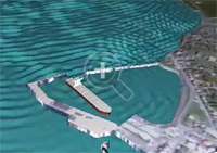 |
| Click here to view an example of the possibilities of this new feature. |
With MIKE Animator Plus, you can create visual animations to present you model results – and as something new, you will be able to include visualisation of solids. Through the inclusion of solids, you can improve your animations significantly by enhancing realism and recognition of locations, for example by including fixed elements like buildings and dams or moving elements like ships. Release 2014 will support the placement of solids inside the model domain and allow them to move, which means that a ship can be sailing as part of the animation.
MIKE HYDRO Basin: Global prioritisation of water users
MIKE HYDRO Basin was introduced with the current release 2012, containing a large number of features relevant for integrated river basin management applications. Developments continue for MIKE HYDRO Basin and the new release will introduce another very interesting new feature to modellers of river basin water allocation schemes and resources management; Global Prioritisation.
With this new feature, it is now possible to include a user defined prioritisation of water users within the basin model - regardless of their geographical location within the basin. Thus, it highly increases the applicability of MIKE HYDRO Basin for specific types of water resources management applications.
The global prioritisation of water users are defined through ‘Ranking’ number definitions, where water consumers are assigned an individual ranking number. The ranking numbers are used during simulation to prioritise consumers, in case of water shortage, in order to accommodate the water demands for these - taking into account that some users have a higher priority than others.
Mesh Generation: A new tool for creating flexible meshes from dfs2 files and other sources
In order to assist those, who want to transfer existing models or bathymetries into the FM system, Release 2014 will contain a new tool, aimed to convert bathymetries in other formats into FM format.
The new Mesh Converter is included in the MIKE Zero Toolbox and supports DHI’s own format from the ‘classic’ modelling series, dfs2 as well as some external formats (ADCIRC, SMS, TUFLOW). The process is quick and easy and produces an equal bathymetry in FM format, which can then be modified using all the existing editing facilities of MIKE Zero’s Mesh Generator.
New features in FEFLOW 6.2
Groundwater age calculation in FEFLOW 6.2
Groundwater Age is a new type of problem class, similar to mass or heat transport. With this, many questions can be easily answered, such as:
- How long is the average underground travel time of water pumped at a well?
- What‘s the percentage of bank filtration at the supply wells?
- What‘s the age and remaining travel time of groundwater at a certain location?
Storage Capture/Release is a new component in the Rate Budget and Period Budget Panels for flow and transport in FEFLOW 6.2. With this new component, you can clearly separate storage change and solution error in transient models.
Increased performance with new MIKE 1D features in MIKE URBAN
In 2012, we introduced a new generic 1D numerical engine for MIKE by DHI products. With the upcoming release of MIKE URBAN 2014, a number of new features for MIKE 1D will be available such as:
- coupling to MIKE SHE
- options for Advection-Dispersion modelling
- result presentation in MIKE URBAN
- and many more…
Strengthening wastewater modelling projects with new features in WEST 2014
Our WEST software package, for modelling wastewater treatment plants, has quickly established itself as an important product in the MIKE by DHI family with a growing number of users all over the world. Release 2014 includes several important new features, including:
- New Report Generator, which enables the user to automatically create reports containing graphs and data pertaining to a project in a variety of formats including: project information, plant layout, plots and tables.
- Integrated urban water system (IUWS) libraries, making WEST a powerful tool for identifying synergies and to globally optimise the wastewater system performance on a catchment scale.
We are also pleased to inform you that Release 2014 of WEST will include a plant wide model (PWM) for simulating nutrient removal activated sludge systems.
The plant wide model, ‘PWM_SA’, is a three phase model for the simulation of nutrient removal activated sludge systems coupled with the anaerobic (organisms independent of oxygen), aerobic (organisms dependent on oxygen) and anoxic-aerobic digestion of sewage sludge. This includes waste activated sludge produced by biological excess phosphorus removal plants. The model is based on strict material mass balance and is prepared by linking:
- a variation of ASM2 for activated sludge nitrogen and phosphorus removal and aerobic or anoxic–aerobic digestion
- a variation of the UCT anaerobic digestion model.
The plant wide model is developed jointly by our WEST Development Centres, the Universities of Cape Town (UCT) and kwaZulu-Natal in South Africa.
Thursday, 28 March 2013
MIKE FM Series HPC trial at the University of Southampton
DHI is working with the University of Southampton, with input from ABPmer, on a UK trial of MIKE 21 FM HPC using IRIDIS (the University's 12,000 core HPC cluster). The current results, as presented by Steve Flood (DHI), are impressive.
DHI is working with the University of Southampton, with input from ABPmer, on a UK trial of MIKE 21 FM HPC using IRIDIS (the University's 12,000 core HPC cluster). The current results, as presented by Steve Flood (DHI), are impressive.
MIKE FM HPC Trial from sjf_dhi
Tuesday, 8 February 2011
Example tidal inundation model at Sutton Harbour, Plymouth using standard structures available within MIKE 21 Flexible Mesh
Introduction
 The Sutton Harbour area of Plymouth is defended against tidal flooding primarily by a system of lock gates at the entrance to the inner harbour. It is understood that the defended level afforded by the lock gates is 4.03m A.O.D (although a number of openings in the parapet wall of the southern harbour wall may slightly compromise the level of defence). This example investigates the suitability of the existing defences to accommodate a 1 in 200-year tidal event plus an allowance for climate change.
 LIDAR data, for use in the model, was obtained from the Channel Coastal Observatory Data Catalogue here http://www.channelcoast.org/. Downloading data and reports from the Channel Coastal Observatory Data Catalogue is currently free of charge (registration is required).
Introduction

Additional notes: It is assumed that all surface water outfalls into the inner harbour have been bypassed; hence, flooding from urban drainage has been ignored. No assessment of wave height has been included within this example. The aerial photograph above was obtained from the Channel Coastal Observatory Data Catalogue (see below).

Additional notes: CCO LIDAR data was verified by comparison with EA LIDAR data and augmented by additional depth values.
Thursday, 20 January 2011
Coast & Sea
LITPACK Redesign
Release 2011 includes a complete redesign of LITPACK, the modelling package for coastal sediment transport and morphology. The redesign includes:
The redesign is a step towards integration in the coupled MIKE 21 FM.
Cyclone Tool
The MIKE 21 toolbox includes a tool for computing wind and pressure fields generated by a cyclone, hurricane or typhoon.
The old Cyclone Tool uses a parametric model developed in the early 1980s that in some cases overpredicts winds.
In Release 2011, several newer parametric models of the cyclone process have been added.
MIKE 21 SW
The Spectral Wave module includes numerous improvements:
MIKE 21/3 FM Improvements
Apart from the significant speed improvements, several other new features are included in Release 2011:
Particle Tracking and New Oil Spill in FM
Release 2011 also includes an improved Particle Tracking module for the FM series. The module includes added features and larger flexibility in terms of output and functionality.
Now the FM series also includes an oil spill module with the same backbone as the Particle Tracking module.
Mesh Generator Enhancements
The new version of the Mesh Generator tool includes several major enhancements including:
LITPACK Redesign
Release 2011 includes a complete redesign of LITPACK, the modelling package for coastal sediment transport and morphology. The redesign includes:
- A new user interface
- Common setup file for all LITPACK modules
- Flexible definition of input values (constant/time varying/spatially varying)
- User specification of output parameters
- Graphical view of setup in georeferenced domain
- Additional functionality, e.g. calculation of Q-Alpha curves
- Improved Rose Plot: 3rd item defines duration of event
- Improved Profile Editor: Georeferenced line series data
- Improved Project Map: Line series display included
The redesign is a step towards integration in the coupled MIKE 21 FM.
Cyclone Tool
The MIKE 21 toolbox includes a tool for computing wind and pressure fields generated by a cyclone, hurricane or typhoon.
The old Cyclone Tool uses a parametric model developed in the early 1980s that in some cases overpredicts winds.
In Release 2011, several newer parametric models of the cyclone process have been added.
MIKE 21 SW
The Spectral Wave module includes numerous improvements:
- Significant performance improvement by domain decomposition
- Improved convergence of quasi-steady component
- Output of wave power
- Improved description of structures
MIKE 21/3 FM Improvements
Apart from the significant speed improvements, several other new features are included in Release 2011:
- Dynamic update of bathymetries (for dam/dune breaks, morphological seabed changes)
- Improved description of velocity profiles in river simulations
Particle Tracking and New Oil Spill in FM
Release 2011 also includes an improved Particle Tracking module for the FM series. The module includes added features and larger flexibility in terms of output and functionality.
Now the FM series also includes an oil spill module with the same backbone as the Particle Tracking module.
Mesh Generator Enhancements
The new version of the Mesh Generator tool includes several major enhancements including:
- Handling of large scatter data,
- Performance improvement for editing and interpolation in large scatter data sets, and
- Prioritisation of scatter data
Tuesday, 20 April 2010
Simulation of dam break flow around buildings using a high-resolution MIKE FLOOD FM (Flexible Mesh) model
Introduction
The following example is intended to augment the MIKE FLOOD Classic (SG) results presented within the forthcoming Environment Agency Science Report 'Benchmarking of 2D Hydraulic Modelling Packages'. Information on this study can currently be found in the 'Desktop Review of 2D Hydraulic Software Packages' report; available here (opens PDF document).
This dam break test has been adapted from an original benchmark test case available from the IMPACT project (IMPACT, 2004; Soares-Frazao and Zech, 2002), for which measurements from a physical laboratory model at the Civil Engineering Laboratory of the Université Catholique de Louvain (UCL) are available. The test involves a simple topography, a dam with a 1.0m wide opening, and an idealised representation of a single building downstream of the dam.

Software used
Product: MIKE FLOOD FM (Flexible Mesh)
Version: 2009 including Service Pack 3
Numerical scheme: Finite Volume (FV) [2]
Hardware used
Processor type: Intel Core 2 Quad CPU Q9450
Speed: 2.66 GHz
RAM: 4.00 GB
Model Parameters
 Model bathymetry: Triangular elements have been used to improve the definition of the building as above (quadrangular elements have been used elsewhere, at an approximate grid resolution of 0.1m, particularly to improve definition of model bathymetry along the base slopes and to refine flow through the gate opening).
Time increment (s): 0.02 (adaptive 0.001 - 0.02)
Flood and Dry: Drying depth = 0.001, Flooding depth = 0.002 & Wetting depth = 0.005
Eddy viscosity (m2/s): Smagorinsky formulation (default)
Bed resistance: Manning's M = 100
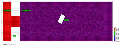 Initial conditions: Uniform depths of 0.4m upstream from the dam and 0.02m downstream from the dam.
 Boundary conditions: Flow is contained by vertical walls at all boundaries of the model domain (only a section of the full model is presented above).
Model Results
Grid resolution (m): 38053 nodes / 38690 elements
Total simulation time (s): 149
 Maximum water surface elevations reached during the simulation (m); transformed 0.05m grid resolution.
 Maximum velocities reached during the simulation (m/s); transformed 0.05m grid resolution.
 MIKE 21 Flow Model FM point series output locations.
 Plot of water surface elevation against time for all point series output locations (m)
 Plot of velocity against time for all point series output locations (m/s)

Introduction
The following example is intended to augment the MIKE FLOOD Classic (SG) results presented within the forthcoming Environment Agency Science Report 'Benchmarking of 2D Hydraulic Modelling Packages'. Information on this study can currently be found in the 'Desktop Review of 2D Hydraulic Software Packages' report; available here (opens PDF document).
This dam break test has been adapted from an original benchmark test case available from the IMPACT project (IMPACT, 2004; Soares-Frazao and Zech, 2002), for which measurements from a physical laboratory model at the Civil Engineering Laboratory of the Université Catholique de Louvain (UCL) are available. The test involves a simple topography, a dam with a 1.0m wide opening, and an idealised representation of a single building downstream of the dam.
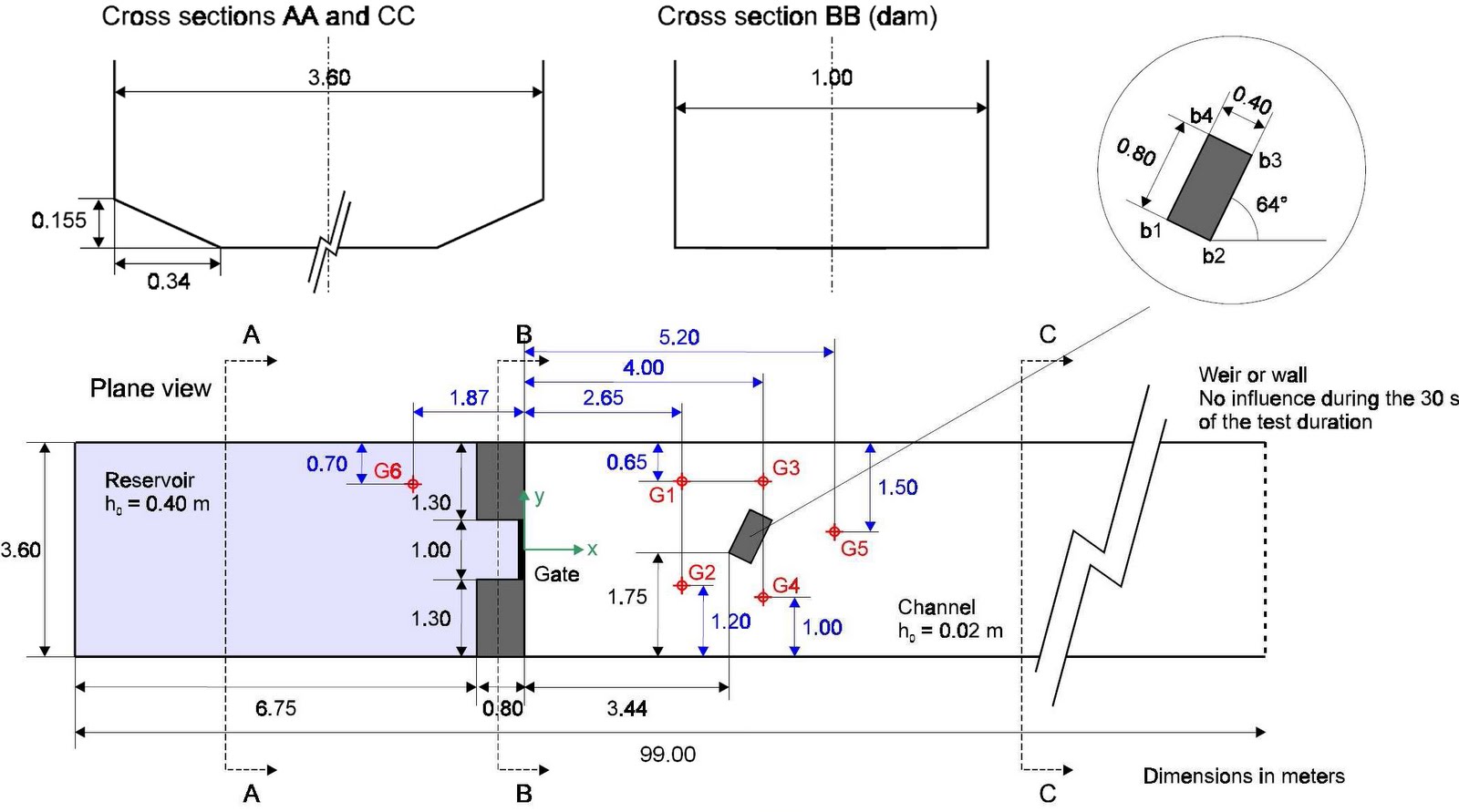
Model Set-up (adapted from Soares-Frazao and Zech, 2002).
[1] The SOARES-FRAZAO, S. AND ZECH, Y., 2002 Dam break flow experiment (Isolated building test case) is available online at http://www.impact-project.net/wp3_technical.htm
Software used
Product: MIKE FLOOD FM (Flexible Mesh)
Version: 2009 including Service Pack 3
Numerical scheme: Finite Volume (FV) [2]
Hardware used
Processor type: Intel Core 2 Quad CPU Q9450
Speed: 2.66 GHz
RAM: 4.00 GB
[2] The numerical solution of the shallow water equations (2D cases) uses an approximate Riemann solver (Roe’s scheme; Roe, 1981) to calculate the convective fluxes at the interface of the triangular and/or quadrangular cells/elements. Average gradients are estimated using the approach by Jawahar and Kamath, 2000. Numerical oscillations are avoided using a second order TVD slope limiter (Van Leer limiter; Hirch, 1990 and Darwish, 2003).
Model Parameters

Time increment (s): 0.02 (adaptive 0.001 - 0.02)
Flood and Dry: Drying depth = 0.001, Flooding depth = 0.002 & Wetting depth = 0.005
Eddy viscosity (m2/s): Smagorinsky formulation (default)
Bed resistance: Manning's M = 100


Model Results
Grid resolution (m): 38053 nodes / 38690 elements
Total simulation time (s): 149
Animation of water surface elevations in first 30-seconds of simulation (m)

Animation of velocities in first 30-seconds of simulation (m/s)


Detailed comparison of MIKE FLOOD FM modelled water surface elevations and UCL laboratory observations (click to enlarge).
Animation of water surface elevations showing development of hydraulic jump (m)
.
.
Wednesday, 19 August 2009
Demonstration model of tidal flows around Guernsey and Sark, The Channel Islands, for renewable energy production
Introduction
The Channel Islands have one of the highest resources of tidal flow energy in the United Kingdom. This simple modelling exercise has been undertaken in order to demonstrate the functionality and capability of MIKE 21 to investigate the viability of harnessing the tidal flows around Guernsey and Sark for energy production.


Defining the Hydrodynamic Model

Define model domain; import shoreline data, redistributing vertices to prepare for mesh generation

Increase definition at study area

Create computational mesh; increase definition in study area

Bathymetry data; depth values extracted from MIKE C-MAP for greater accuracy at study area

Bathymetry data; ETOPO1 1-minute grid (Amante, C. and B. W. Eakins, ETOPO1 1 Arc-Minute Global Relief Model: Procedures, Data Sources and Analysis, National Geophysical Data Center, NESDIS, NOAA, U.S. Department of Commerce, Boulder, CO, August 2008)

Interpolated bathymetry; water depths (study area) relative to Chart Datum [1]

Mean Sea Levels relative to Chart Datum

Adjusted model bathymetry; water depths relative to Mean Sea Level

Assign tidal boundary conditions to East & West boundaries; line time series generated using MIKE 21 Toolbox (prediction based on global tide model data)
West boundary
Model Results

Calibration against UKHO tidal predictions for St Peter Port over the study period; good correlation, parameters are appropriate for the purpose of this modelling exercise
Animation of tidal current velocities; The Channel
Animation of tidal current velocities; Channel Islands
Animation of tidal current velocities; Guernsey & Sark

Introduce turbine structures between Guernsey & Sark; Turbine 1 (North) & Turbine 2 (South). Assumed parameters; Turbine diameter = 16m, Drag coefficient = 0.4

Modelled turbine velocity (m/s); assumed criteria for viability > 1m/s (say 2m/s for spring tides)
The energy available from the turbines can (for example) be estimated as follows: -

Modelled turbine force (N)

Consider the effects of renewable energy installations in Alderney Race

Introduce pier structures. Assumed parameters; Height = 100m, Diameter = 25m.
The impact of these pier structures on modelled tidal current velocities is negligible in this example.
.
Introduction
The Channel Islands have one of the highest resources of tidal flow energy in the United Kingdom. This simple modelling exercise has been undertaken in order to demonstrate the functionality and capability of MIKE 21 to investigate the viability of harnessing the tidal flows around Guernsey and Sark for energy production.
Defining the Hydrodynamic Model
- A triangular element flexible mesh has been applied over the entire model domain; comprising 38679 Elements & 20405 Nodes
- An overall time step of 300 seconds has been selected. The duration of the simulation is 7 days (2016 overall time steps). The simulation period covers an arbitrary week from 03/07/2009 – 10/07/2009. as such, higher spring tides have not been considered in this example.
- The horizontal eddy viscosity type has been set to a velocity based Smagorinsky formulation with a constant value of 0.28
- The bed resistance type has been set to Manning number and a constant value of 32 m1/3/s applied
- Coriolis forcing has been set to varying in domain
- Wind forcing has not been considered
Define model domain; import shoreline data, redistributing vertices to prepare for mesh generation
Increase definition at study area
Create computational mesh; increase definition in study area
Bathymetry data; depth values extracted from MIKE C-MAP for greater accuracy at study area
Bathymetry data; ETOPO1 1-minute grid (Amante, C. and B. W. Eakins, ETOPO1 1 Arc-Minute Global Relief Model: Procedures, Data Sources and Analysis, National Geophysical Data Center, NESDIS, NOAA, U.S. Department of Commerce, Boulder, CO, August 2008)
Interpolated bathymetry; water depths (study area) relative to Chart Datum [1]
[1] Datum info: Chart Datum (CD) is usually equal to LAT in the UK (e.g. see http://www.ordnancesurvey.co.uk/oswebsite/partnerships/research/publications/docs/2003/ICZMAP_GISRUK_full_dm.pdf for height integration at the coastal zone). For a global relief model, like ETOPO2v2, which has 2 arc-minute (~4 km) cell size, the differences between vertical datums are considered to be not significant, so long as they are all near Mean Sea Level (MSL). As such, a height correction should be applied to datasets relative to Chart Datum (see below).
Mean Sea Levels relative to Chart Datum
Adjusted model bathymetry; water depths relative to Mean Sea Level
Assign tidal boundary conditions to East & West boundaries; line time series generated using MIKE 21 Toolbox (prediction based on global tide model data)
West boundary
Model Results
Calibration against UKHO tidal predictions for St Peter Port over the study period; good correlation, parameters are appropriate for the purpose of this modelling exercise
Animation of tidal current velocities; The Channel
Animation of tidal current velocities; Channel Islands
Animation of tidal current velocities; Guernsey & Sark
Introduce turbine structures between Guernsey & Sark; Turbine 1 (North) & Turbine 2 (South). Assumed parameters; Turbine diameter = 16m, Drag coefficient = 0.4
Modelled turbine velocity (m/s); assumed criteria for viability > 1m/s (say 2m/s for spring tides)
The energy available from the turbines can (for example) be estimated as follows: -
P = Cp x 0.5 x ρ x A x V³where: -
P = power generated (W)
Cp = turbine performance coefficient
ρ = water density (seawater ~ 1025 kg/m³)
A = sweep area of the turbine (m²)
V = flow velocity (m/s)
Modelled turbine force (N)
Consider the effects of renewable energy installations in Alderney Race
Introduce pier structures. Assumed parameters; Height = 100m, Diameter = 25m.
The impact of these pier structures on modelled tidal current velocities is negligible in this example.
.
Subscribe to:
Posts
(Atom)
Follow DHI...


