Showing posts with label ECO Lab. Show all posts
Showing posts with label ECO Lab. Show all posts
Monday, 15 December 2014
Coupling groundwater and ecological models (MIKE-SHE & ECO Lab) - Roberta-Serena Blasone (DHI)
Delivered at: -
Groundwater Modelling Workshop 2014:
Pushing the Boundaries – New Issues and Applications in Groundwater Modelling
13 May 2014 - Birmingham, UK
Coupling groundwater and ecological models (MIKE-SHE & ECO Lab) - Roberta-Serena Blasone (DHI) from sjf_dhi
Delivered at: -
Groundwater Modelling Workshop 2014:
Pushing the Boundaries – New Issues and Applications in Groundwater Modelling
13 May 2014 - Birmingham, UK
Tuesday, 12 August 2014
River water quality modelling using MIKE 11 ECO Lab - Vera Jones (Atkins)
Presented at the 2014 MIKE by DHI UK Symposium on 13th to 14th May 2014.
Presented at the 2014 MIKE by DHI UK Symposium on 13th to 14th May 2014.
Monday, 28 April 2014

Pushing the Boundaries – New Issues and Applications in Groundwater Modelling
Date: 13 May 2014
Event type: Conference
Organised by: Groundwater Modeller’s Forum, Hydrogeological Group
Venue: Birmingham
The UK Groundwater Modellers’ Forum is holding its 12th workshop on new issues and applications in groundwater modelling in the UK. Read more >>>
DHI will be presenting at the above Groundwater Modellers' Forum event on the 13th May 2014. Roberta-Serena Blasone (DHI) will give a talk on 'Coupling groundwater and ecological models (MIKE SHE & ECO Lab)' at the conference, focussing upon: -
- Two of the key objectives of the European Water Framework Directive (WFD) are: 1) to protect and enhance the status of aquatic ecosystems (and terrestrial ecosystems and wetlands directly dependent on aquatic ecosystems) and 2) to provide for sufficient supply of good quality surface water and groundwater as needed for sustainable, balanced and equitable water use. These requirements, together with the growing acceptance of the integrated water resource management approaches that treat catchment management holistically, provide a strong motivation to develop integrated hydrological and water quality tools that can address problems related to ecological status and restoration. In particular, managers need to be able to quantify changes in ecosystem status caused by changes in catchment management. A new and powerful eco-hydrological modelling tool has been developed, combining a generic ecological modelling tool (ECO Lab) with a fully integrated catchment modelling tool representing surface water, soil- and groundwater as well as water quality processes (MIKE SHE). This paper will present applications of this new tool to case studies involving wetland ecosystems in Denmark and the US.
Monday, 2 December 2013

Development of new modelling tools for national marine water planning based on ECO Lab
Our ecological modelling software, ECO Lab, will be used in a new project with the aim to develop an advanced set of dynamic modelling tools, which will be the official tools for marine water planning in Denmark in the coming years.
The project is initiated as a collaboration between DHI and Danish Centre for Environment and Energy (DCE). The project will develop and apply ecosystem models by using our MIKE by DHI software, ECO Lab, and addressing the governing coastal processes and ecosystem services such as sediment processes, sea grass, algal growth and oxygen depletion.
For more information, click here or contact Anders Erichsen, DHI.
You can also read more about ecological modelling by clicking the links below:
- Applying ECO Lab for solving ecosystem challenges
- Modelling the behaviour of organisms with ABM Lab in response to the environment
Enabling optimised construction of the London Array offshore wind farm
Our real-time system provided accurate forecasts of Metocean conditions on a detailed spatial and temporal scale for the world’s largest wind farm – London Array. This enabled London Array Ltd. – the consortium behind the wind farm – to optimise the construction of the offshore wind farm. The result: minimised delays and ensured safety for those working on the project.
Situated in the outer Thames Estuary, is the world’s largest offshore wind farm: the 1 GW London Array. Weather conditions in this area are often challenging, which made construction and installation of the wind farm difficult. As such, high-quality and reliable Metocean data was vital for the successful planning and installation of London Array’s foundations and turbines.
London Array Ltd. needed to be able to predict available weather windows. We used our 30 years of experience in Metocean forecasting for this purpose. This ensured that the London Array project benefitted from the most up-to-date and advanced technologies, combined with local experience of forecasting techniques and equipment.
By assisting London Array Ltd. with forecasting Metocean conditions, our system helped keep delays to a minimum during the construction phase. In addition, our system also enabled London Array Ltd. to efficiently plan maintenance work during the operations phase.
Read more.
CARM wins Australia’s national Environmental Engineering Excellence Award
On 20 November 2013, the Institution of Engineers Australia awarded the Computer Aided River Management (CARM) project the Environmental Engineering Excellence Award. This prestigious award honours the top achievements in environmental engineering and the sustainable use of natural resources. The award was received by our client State Water Corporation of New South Wales.
Our software is the backbone of CARM – a Decision Support System (DSS) based on MIKE CUSTOMISED by DHI components. CARM gives State Water Corporation an insight into the current and forecasted state of the Murrumbidgee River. It utilises a suite of MIKE by DHI models to reproduce key catchment and river processes for the entire 1,600 km river system, and combines them with real-time measurements. This allows river operators to combine dam releases with natural tributary inflows to deliver the right amount of water when and where it is needed.
For more information on the CARM project, click here
Read the October 2013 Edition of the DHI Group newsletter here.
Friday, 26 July 2013
UK Hazard Mapping with MIKE FLOOD and ECO Lab: Solving the Debris Factor Problem in 2D Flood Modelling
MIKE by DHI Release 2012 introduced an option for generating Flood Hazard Maps in MIKE 21 / MIKE FLOOD using ECO Lab (without the need for customers to have an ECO Lab module in their licence!).
Depending upon the approach adopted (e.g. the ‘Flood Risks to People’ guidance from Defra / EA) MIKE FLOOD can utilise the flood water depths, velocities, and land use data to seamlessly calculate both the correct debris factor and appropriate flood hazard rating in each grid cell / element and at each time step in a simulation.
For the UK, the templates are based upon the Environment Agency document 'SUPPLEMENTARY NOTE ON FLOOD HAZARD RATINGS AND THRESHOLDS FOR DEVELOPMENT PLANNING AND CONTROL PURPOSE – Clarification of the Table 13.1 of FD2320/TR2 and Figure 3.2 of FD2321/TR1'.
Download the templates and supporting documentation here: -
The templates are provided ‘As is’ without warranty, so please check the results carefully if you use them.
For more information, and to request changes or updates to the templates, please e-mail mikebydhi.uk@dhigroup.com
MIKE by DHI Release 2012 introduced an option for generating Flood Hazard Maps in MIKE 21 / MIKE FLOOD using ECO Lab (without the need for customers to have an ECO Lab module in their licence!).
Depending upon the approach adopted (e.g. the ‘Flood Risks to People’ guidance from Defra / EA) MIKE FLOOD can utilise the flood water depths, velocities, and land use data to seamlessly calculate both the correct debris factor and appropriate flood hazard rating in each grid cell / element and at each time step in a simulation.
For the UK, the templates are based upon the Environment Agency document 'SUPPLEMENTARY NOTE ON FLOOD HAZARD RATINGS AND THRESHOLDS FOR DEVELOPMENT PLANNING AND CONTROL PURPOSE – Clarification of the Table 13.1 of FD2320/TR2 and Figure 3.2 of FD2321/TR1'.
Download the templates and supporting documentation here: -
- ECO Lab templates for the calculation of Flood Hazard Rating using MIKE FLOOD or MIKE 21
- Stamped (License free) Hazard-Templates (.zip file*)
- Background information
The templates are provided ‘As is’ without warranty, so please check the results carefully if you use them.
For more information, and to request changes or updates to the templates, please e-mail mikebydhi.uk@dhigroup.com
Tuesday, 23 July 2013
Using MIKE FLOOD AD and ECO Lab to model polluted flood waters and riverine water quality
MIKE FLOOD now includes the option for a fully dynamic 1D-2D Advection Dispersion coupling, which increases the range of applications substantially.
The new AD coupling in MIKE FLOOD enables users to simulate new interesting aspects such as: -
MIKE FLOOD AD can be further enhanced by ECO Lab for advanced water quality simulations.
ECO Lab is the complete numerical laboratory for water quality and ecological modelling. You can develop exactly the model you need and describe the processes you wish. No ecological problem is too simple or too complicated for ECO Lab:
MIKE FLOOD now includes the option for a fully dynamic 1D-2D Advection Dispersion coupling, which increases the range of applications substantially.
The new AD coupling in MIKE FLOOD enables users to simulate new interesting aspects such as: -
- Floodplain contamination from polluted rivers.
- Impact assessment on river quality from pollutant sources in flood prone areas during flood events.
- The impact on concentrations of river pollutant in case of a release from an urban Combined Sewer Overflow.
MIKE FLOOD AD can be further enhanced by ECO Lab for advanced water quality simulations.
ECO Lab is the complete numerical laboratory for water quality and ecological modelling. You can develop exactly the model you need and describe the processes you wish. No ecological problem is too simple or too complicated for ECO Lab:
- Open Equation solver for coupled ordinary differential equations.
- Designed for point descriptions of processes of chemistry, ecology, etc.
- All equations, parameters contained in flexible, portable ECO Lab templates (use DHI supported templates or create your own).
- Integrated with DHI’s hydrodynamic models: Currently MIKE 11, MIKE 21 (hence MIKE FLOOD), MIKE 3 & MIKE SHE.
Monday, 20 May 2013
River Almond Valley Water Quality Modelling Strategic Study
Atkins was commissioned to produce a dynamic water quality model of the River Almond using MIKE 11 ECO Lab. Vera Jones presents the project details which considered the impacts of Scottish Water’s local assets and identified strategies for compliance with the Water Framework Directive (WFD) and Urban Wastewater Treatment Directive (UWWTD).
Atkins was commissioned to produce a dynamic water quality model of the River Almond using MIKE 11 ECO Lab. Vera Jones presents the project details which considered the impacts of Scottish Water’s local assets and identified strategies for compliance with the Water Framework Directive (WFD) and Urban Wastewater Treatment Directive (UWWTD).
Sunday, 14 October 2012
Previews of MIKE by DHI Release 2012
The MIKE by DHI Release 2012 is just around the corner. As in previous issues of our newsletter, we would like to disclose a preview of the many new and exciting features, which we hope will improve your experience with the software products, regarding usability, productivity as well as enhanced applications.
Introducing ABM Lab
 In version 2012 of MIKE by DHI we proudly present a world premiere: Agent based modelling integrated with our hydrodynamic models in two and three dimensions (MIKE 21 and MIKE 3). Agent based modelling (also called individual based modelling) describes the autonomic behaviour and states of agents, objects or individuals. ABM Lab makes it possible to address questions that are beyond the scope of more traditional water quality models. ABM Lab is a flexible numerical laboratory where the user can define agents, their behaviour and states. The Langragian ABM Lab can work with the hydrodynamics alone or it can be combined with the Eulerian ECO Lab, in order to make the agents react to water quality parameters.
Examples of applications are: -
As a part of Release 2012, we are also happy to announce the first release of MIKE HYDRO.
MIKE HYDRO is our new, common Graphical User Interface framework, which offers the latest generation of a map-based, easy to use and work-flow oriented user interface. The user interface has the Graphical View as a central component for definition and editing of model features, a Tree-view for easy navigation through model elements and tabular property views for efficient, bulk-editing of model parameters.
Through a staged implementation, MIKE HYDRO will become the common Graphical User Interface for most of DHI's Water Resources products and new features and products are added in coming major releases.
The first MIKE HYDRO release includes our Basin module, which is a multipurpose, map-based decision support tool for integrated river basin analysis, planning and management. MIKE HYDRO Basin is designed for analysing water sharing issues at international and national or local river basin level.
Typical applications of MIKE HYDRO Basin include: -
The MIKE by DHI Release 2012 is just around the corner. As in previous issues of our newsletter, we would like to disclose a preview of the many new and exciting features, which we hope will improve your experience with the software products, regarding usability, productivity as well as enhanced applications.
Introducing ABM Lab
Examples of applications are: -
- Coral spawn modelling. Numerical modelling of the impacts of dredging plumes on coral spawning and recruitment
- Modelling eelgrass succession patterns, determining the recolonisation of eelgrass
- The houting project: modelling the migration of salmonide fish larvae through different wetland construction designs
- Modelling of Bull Shark migration patterns in a semi-enclosed eco-system
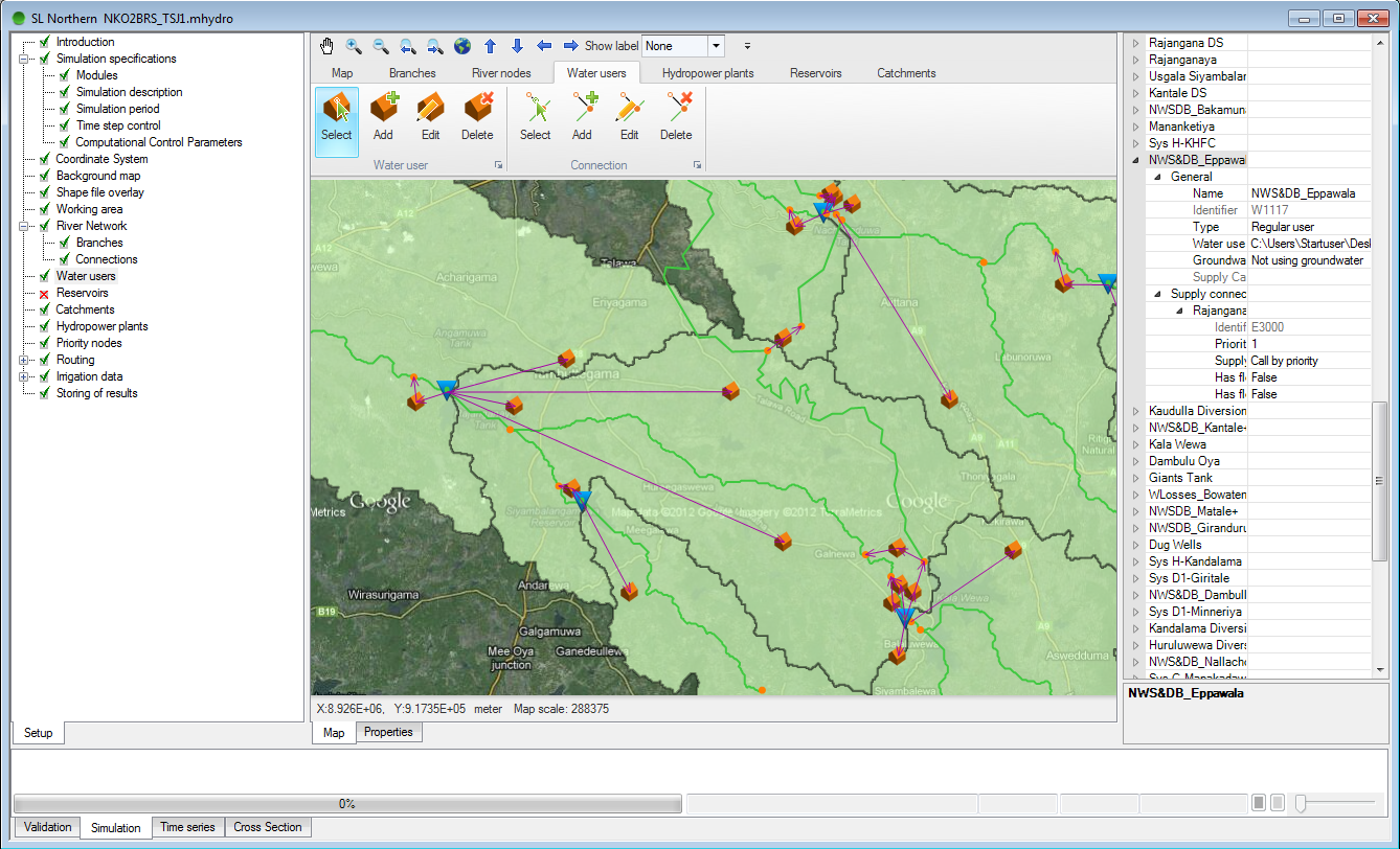 |
| An example of a river basin management model – overview in MIKE HYDRO. |
MIKE HYDRO is our new, common Graphical User Interface framework, which offers the latest generation of a map-based, easy to use and work-flow oriented user interface. The user interface has the Graphical View as a central component for definition and editing of model features, a Tree-view for easy navigation through model elements and tabular property views for efficient, bulk-editing of model parameters.
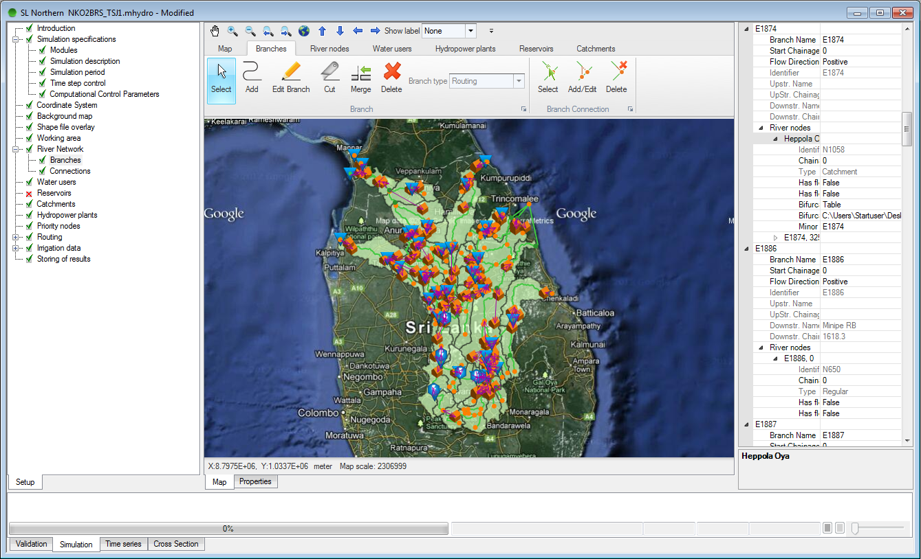 |
| An example of a river basin management model – excerpt with more details including reservoirs and different types of water users. Click on the illustrations to enlarge. |
The first MIKE HYDRO release includes our Basin module, which is a multipurpose, map-based decision support tool for integrated river basin analysis, planning and management. MIKE HYDRO Basin is designed for analysing water sharing issues at international and national or local river basin level.
Typical applications of MIKE HYDRO Basin include: -
- Integrated Water Resources Management (IWRM) studies
- Provision of multi-sector solution alternatives to water allocation and water shortage problems
- Improvements and/or optimisation of reservoir and hydropower operations
- Exploring of conjunctive use of groundwater and surface water
- Evaluation and improvement of irrigation scheme performance
- Numerous water allocation and sharing algorithms
- Advanced reservoir operation options
- Detailed hydropower simulation
- Irrigation water demand and crop yield estimation
- Hydrological modelling
- Catchment and river delineation tool
- Reservoir sedimentation from sediment loads
- Scripting options for tailored optimisation and scenario simulations
Sunday, 9 September 2012
Large scale Interactive coupled 3D modelling for wave and tidal energy resource and environmental impact using MIKE Software
Scotland has substantial wave and tidal energy resources and is at the forefront of the development of marine renewable technologies and ocean energy exploitation. Wave and tidal energy devices will soon be deployed in arrays, with many sites being developed. It is therefore essential to understand how a number of multi-site developments collectively impact on the physical and biological processes over a wider region. Careful selection of array sites may enable the optimum exploitation of the resource while minimising any environmental impacts to an acceptable level.
The TeraWatt project is a £1m project funded by the Engineering and Physical Sciences Research Council through its Marine Challenge Fund. The project consortium has been established under the auspices of the Marine Alliance for Science and Technology for Scotland (MASTS) with scientists from the Universities of Heriot-Watt, Edinburgh, Highlands and Islands, Strathclyde, Swansea and Aberdeen, and Marine Scotland Science (MSS). The overarching objective of the research is to generate a suite of methodologies that can provide a better understanding of the impact of energy extraction on the resource. Approaches will also be developed that can be employed to assess the physical and ecological consequences of changes to the resource. The project objective will be met by investigating spatial changes in wave climate, physical processes affecting sediments, the shoreline & seabed, and the impacts on organisms living in the seabed, their distribution and the significance of these for other ecological processes.
MIKE by DHI software has been chosen by the TeraWatt Consortium to support their research. Coupled MIKE 3 FMHD and MIKE 21 SW models form the foundations of the adopted MIKE software platform. These core models will be augmented by MIKE 21 BW, MIKE 3 FMMT, MIKE 3 FMST, LITPACK, MIKE 3 FM ECO Lab & ABM Lab, EVA and MIKE Animator in order to consider the specific responsibilities of each partner university.
For more information about the above MIKE by DHI software, please contact Steve Flood on sjf@dhigroup.com
.
Scotland has substantial wave and tidal energy resources and is at the forefront of the development of marine renewable technologies and ocean energy exploitation. Wave and tidal energy devices will soon be deployed in arrays, with many sites being developed. It is therefore essential to understand how a number of multi-site developments collectively impact on the physical and biological processes over a wider region. Careful selection of array sites may enable the optimum exploitation of the resource while minimising any environmental impacts to an acceptable level.
The TeraWatt project is a £1m project funded by the Engineering and Physical Sciences Research Council through its Marine Challenge Fund. The project consortium has been established under the auspices of the Marine Alliance for Science and Technology for Scotland (MASTS) with scientists from the Universities of Heriot-Watt, Edinburgh, Highlands and Islands, Strathclyde, Swansea and Aberdeen, and Marine Scotland Science (MSS). The overarching objective of the research is to generate a suite of methodologies that can provide a better understanding of the impact of energy extraction on the resource. Approaches will also be developed that can be employed to assess the physical and ecological consequences of changes to the resource. The project objective will be met by investigating spatial changes in wave climate, physical processes affecting sediments, the shoreline & seabed, and the impacts on organisms living in the seabed, their distribution and the significance of these for other ecological processes.
MIKE by DHI software has been chosen by the TeraWatt Consortium to support their research. Coupled MIKE 3 FMHD and MIKE 21 SW models form the foundations of the adopted MIKE software platform. These core models will be augmented by MIKE 21 BW, MIKE 3 FMMT, MIKE 3 FMST, LITPACK, MIKE 3 FM ECO Lab & ABM Lab, EVA and MIKE Animator in order to consider the specific responsibilities of each partner university.
For more information about the above MIKE by DHI software, please contact Steve Flood on sjf@dhigroup.com
.
Wednesday, 15 February 2012

The latest MIKE by DHI NetWork newsletter has been published, and selected articles are presented below: -
Product News
- MIKE by DHI ISO 9001 certification: We are proud to announce that DNV has granted DHI the official "ISO 9001: Quality Management Systems" certificate. "Consistent, high quality of not only our software development processes but of the entire user experience with the MIKE products is our single highest priority" says Jørgen Bo Nielsen, Managing Director of the MIKE by DHI global business. Click here to read more about the ISO 9001 certification or click here to read more about it in our latest newsletter.
- MIKE by DHI in the CLOUD: Meet your deadlines without buying more hardware or software. You can now get easy access to more licenses and more hardware through the new MIKE by DHI Software as a Service (SaaS) Portal. Get started with MIKE in the cloud now! Click here to go to the MIKE by DHI SaaS Portal or click here to read more in our latest newsletter.
- Study in Florida accomplishes reduction in dredging frequency: The Matanzas Inlet in Florida and an Intracoastal Waterway close to the inlet were challenged with high waves and high levels of shoaling. This was due to a close proximity to a natural sandy inlet, causing sediment transport into the Intracoastal Waterway. The challenge of high maintenance requirements of the Matanzas Inlet in Florida has caused the Florida Inland Navigation District to initiate a study to investigate the inlet area and examine alternatives to reduce the sediment inflow into the waterways. The study was performed by Taylor engineering and a coastal model was developed using MIKE21. With concerns to the estimated construction and maintenance cost, a deep sediment basin was chosen, from several alternative solutions, which would reduce dredging frequency in the Intracoastal Waterway to one dredging operation every four years as opposed to the previous average of 2.7 years. Read more here.
- Floating breakwater reduces wave heights in tugboat port in Germany: In one of the major ports, Jade Weser Port, in northern Germany the construction of a temporary tugboat port was challenged by high waves of up to 0.8 m for a mean water level of +3.00 m NN within the port. This was caused by an exposed location of the port affected by primarily eastern and northern winds. A study was conducted for client, Inros Lackner, in order to discover ways of reducing the impact of the winds within the port area using a MIKE 21 Boussinesq wave model (BW). The study determined the actual height of the waves and a simulation of the possible reduction was made. The reached solution became a floating breakwater within the port that would reduce the wave heights of about 10–30 pct. With the combination of expert consultancy and high quality software, they were able to reach a solution that was inexpensive, fairly easy to install, and with great result for the client. For more information, read here or please contact Oliver Stoschek or Anja Brüning.
- New insight into Bull Sharks' behaviour in Australia using individual-based modelling: Studying fish, sharks, and other marine mammals is often a challenge due to lack of accurate information that provides a realistic portrait of their living conditions, movements, and the elements that affect their behaviour. Researchers at Griffith University in Queensland in Australia have recently successfully employed an individual-based modelling technique to investigate the habitat and movement patterns of juvenile bull sharks in the Tallebudgera Creek estuary in Australia. The modelling tools in MIKE21 and ECO Lab were used to accurately capture the hydrodynamics of the estuary to create a virtual habitat and integrate tracking results of a number of juvenile bull sharks. Their work has provided new valuable knowledge and a fairly accurate picture of, which elements affect the bull sharks and their living conditions such as water quality, salinity levels, turbidity, and currents. Thus, this use of individual-based modelling paves the way for new possibilities of researching marine mammals in the future. The research project at Griffith University in Australia is a recent example of how MIKE by DHI supports universities by providing software to PHD and MSc students on very favourable conditions. For more information about individual-based modelling, please contact Michael Potthoff. For more information about the specific research on bull sharks, please contact Jonas Brandi Mortensen.
- Flood modelling enlighten community in Iowa, United States: In 2008, the state of Iowa in the United States experienced severe flooding, where many property owners and entire communities suffered. Since then, Iowa Flood Center (IFC) has used MIKE FLOOD modelling of the severe 2008 floods for community outreach and education. "The Iowa Flood Center (IFC), a state-funded center comprised of IIHR–Hydroscience & Engineering researchers, has been using MIKE FLOOD to simulate flood discharges in several Iowa communities. The simulations have been used to numerically reconstruct the severe 2008 Iowa floods and to develop libraries of static inundation maps relating river stage and discharge to flood extents and depths in each community. The intent is to provide communities and individuals an impression of how river stages and discharges forecasted at discrete points may affect their properties." Nathan C Young, Associate Director, Iowa Flood Center. Read more here. The maps are available on the IFC website as part of the Iowa Flood Information System (IFIS).
- Focused mitigation of hazardous urban discharges: Comprehensive monitoring and modelling of discharges of hazardous substances in the Copenhagen Harbour district revealed the most important point sources of selected substances and thereby allows for a sensible and target-oriented prioritisation of future mitigation measures. The present study determined whether or not specific point sources (e.g. wastewater treatment plants, industries or combined sewer overflow) release significant emissions of hazardous substances as listed in the Baltic Sea Action Plan. It was carried out within the framework of the EU-funded COHIBA-project (Control of Hazardous Substances in the Baltic Sea Region) as a combination of wastewater measurements, load estimations and modelling of the discharges (hydrodynamic marine fate modelling with MIKE 3 and ECOlab). Read more.
| Hydrodynamic fate modelling of Bisphenol A in Copenhagen Harbour. The animation shows the modelled discharge, spreading and fate of Bisphenol A after heavy rain, which results in combined sewer overflows. Moreover, industrial discharges are modelled. The model takes into account substance specific fate data (biodegradation, photolysis and hydrolysis) as well as adsorption to suspended solids. |
The newsletter can be viewed online here.
To subscribe to the newsletter(s), please visit http://www.graphicmail.com/rwcode/subscribe.aspx?SiteID=3526&Mode=subscribe
Subscribe to:
Posts
(Atom)
Follow DHI...


