Showing posts with label MIKE SHE. Show all posts
Showing posts with label MIKE SHE. Show all posts
Monday, 15 December 2014
Coupling groundwater and ecological models (MIKE-SHE & ECO Lab) - Roberta-Serena Blasone (DHI)
Delivered at: -
Groundwater Modelling Workshop 2014:
Pushing the Boundaries – New Issues and Applications in Groundwater Modelling
13 May 2014 - Birmingham, UK
Coupling groundwater and ecological models (MIKE-SHE & ECO Lab) - Roberta-Serena Blasone (DHI) from sjf_dhi
Delivered at: -
Groundwater Modelling Workshop 2014:
Pushing the Boundaries – New Issues and Applications in Groundwater Modelling
13 May 2014 - Birmingham, UK
Monday, 28 April 2014

Pushing the Boundaries – New Issues and Applications in Groundwater Modelling
Date: 13 May 2014
Event type: Conference
Organised by: Groundwater Modeller’s Forum, Hydrogeological Group
Venue: Birmingham
The UK Groundwater Modellers’ Forum is holding its 12th workshop on new issues and applications in groundwater modelling in the UK. Read more >>>
DHI will be presenting at the above Groundwater Modellers' Forum event on the 13th May 2014. Roberta-Serena Blasone (DHI) will give a talk on 'Coupling groundwater and ecological models (MIKE SHE & ECO Lab)' at the conference, focussing upon: -
- Two of the key objectives of the European Water Framework Directive (WFD) are: 1) to protect and enhance the status of aquatic ecosystems (and terrestrial ecosystems and wetlands directly dependent on aquatic ecosystems) and 2) to provide for sufficient supply of good quality surface water and groundwater as needed for sustainable, balanced and equitable water use. These requirements, together with the growing acceptance of the integrated water resource management approaches that treat catchment management holistically, provide a strong motivation to develop integrated hydrological and water quality tools that can address problems related to ecological status and restoration. In particular, managers need to be able to quantify changes in ecosystem status caused by changes in catchment management. A new and powerful eco-hydrological modelling tool has been developed, combining a generic ecological modelling tool (ECO Lab) with a fully integrated catchment modelling tool representing surface water, soil- and groundwater as well as water quality processes (MIKE SHE). This paper will present applications of this new tool to case studies involving wetland ecosystems in Denmark and the US.
Thursday, 17 April 2014
Assessing The Impacts Of Rural Land Management Change On Flooding And Flood Risk (The Catchment Approach)
Following on from this post, a few more links focussing on the work of Jong-Sook Park for the Parrett catchment in SW England and its Tone subcatchment: -
Following on from this post, a few more links focussing on the work of Jong-Sook Park for the Parrett catchment in SW England and its Tone subcatchment: -
- http://www.hydrology.org.uk/assets/2010%20papers/035Park_etal.pdf
- https://workspace.imperial.ac.uk/ewre/Public/McIntyre_36.pdf
- http://riverscience.wdfiles.com/local--files/workshop-programme/Park.pdf
Friday, 26 July 2013
Assessing The Impacts Of Rural Land Management Change On Flooding And Flood Risk (The Catchment Approach)
MIKE SHE is a very powerful tool for assessing the effects of natural flood management schemes in the UK. The software has been used extensively for modelling wetland restoration in upland areas in different parts of the world.
The effects of tree planting, water meadows, and other riparian planting can be described by land use changes in the model and the impacts on evapotranspiration, unsaturated flow and surface runoff examined. It is also possible to describe the detention of water in the floodplain (e.g. as a result of tree planting, landscaping, etc).
The effects of cutting off drains, and altering surface flow routes, can be modelled using the MIKE SHE 2D Overland Flow module. Channel restoration and green bank protection can be handled by coupling to MIKE 11.
Natural flood management has many benefits (habitat creation, nature conservation, diffuse pollution mitigation, etc) and is of particular interest in rural rapid response catchments; where it is not always possible to provide flood defences.
A selection of useful (external) documents, papers and links can be found below: -
MIKE SHE is a very powerful tool for assessing the effects of natural flood management schemes in the UK. The software has been used extensively for modelling wetland restoration in upland areas in different parts of the world.
The effects of tree planting, water meadows, and other riparian planting can be described by land use changes in the model and the impacts on evapotranspiration, unsaturated flow and surface runoff examined. It is also possible to describe the detention of water in the floodplain (e.g. as a result of tree planting, landscaping, etc).
 |
| Photo: iStock © Василий Тороус |
Natural flood management has many benefits (habitat creation, nature conservation, diffuse pollution mitigation, etc) and is of particular interest in rural rapid response catchments; where it is not always possible to provide flood defences.
A selection of useful (external) documents, papers and links can be found below: -
- Working with Natural Processes to Manage Flood and Coastal Erosion Risk (Environment Agency, 2010)
- An Inventory of Mitigation Methods and Guide to their Effects on Diffuse Water Pollution, Greenhouse Gas Emissions and Ammonia Emissions from Agriculture (ADAS, 2011)
- Slowing the Flow - A natural solution to flooding problems (WWF Scotland)
- Holnicote Multi-Objective Flood Management Demonstration Project - An Analysis of the Impacts of Rural Land Management Change on Flooding and Flood Risk (JBA, Penny Anderson Associates & National Trust)
- The Holnicote Project - Integrated Catchment Management in Practice (EA and National Trust)
- Catchment Change Management Hub
- Demonstrating Catchment Management - Learning from the Demonstration Test Catchment projects
- Demonstration Test Catchment Data Archive
- WFDVisual - Water Framework Directive Visualisation tool (SNIFFER)
Thursday, 21 February 2013
The use of 3D numerical modelling in groundwater research and water quality risk assessment
Matrix Solutions Inc. in Canada is using MIKE by DHI numerical modelling for ground-breaking research and valuable solutions for their clients. Two recent examples are: -
Feasibility study estimating lithium and potash rich brine deposit reserves
Matrix Solutions developed a 3D numerical modelling tool using among others FEFLOW to represent the complex groundwater flow system and evaluate various wellfield strategies. Using FEFLOW to develop their numerical model, Matrix Solutions was able to significantly reduce simulation time and reach a conclusion supporting a long time and low cost mining operation.
The importance of groundwater–surface water interaction in water resource assessments
In order to better understand and assess the groundwater –surface water interaction, Matrix Solutions applied our integrated modelling software MIKE SHE to two municipal water quality risk assessments in order to evaluate the sustainability of municipal water withdrawals.
Read more in the Matrix Solutions newsletter.
Read the full January 2013 Edition of the MIKE by DHI NetWork newsletter here. Read other recent DHI news stories here.
Matrix Solutions Inc. in Canada is using MIKE by DHI numerical modelling for ground-breaking research and valuable solutions for their clients. Two recent examples are: -
Feasibility study estimating lithium and potash rich brine deposit reserves
Matrix Solutions developed a 3D numerical modelling tool using among others FEFLOW to represent the complex groundwater flow system and evaluate various wellfield strategies. Using FEFLOW to develop their numerical model, Matrix Solutions was able to significantly reduce simulation time and reach a conclusion supporting a long time and low cost mining operation.
The importance of groundwater–surface water interaction in water resource assessments
In order to better understand and assess the groundwater –surface water interaction, Matrix Solutions applied our integrated modelling software MIKE SHE to two municipal water quality risk assessments in order to evaluate the sustainability of municipal water withdrawals.
Read more in the Matrix Solutions newsletter.
Read the full January 2013 Edition of the MIKE by DHI NetWork newsletter here. Read other recent DHI news stories here.
Sunday, 9 September 2012
Previews of MIKE by DHI Release 2012
We are gradually approaching the release of the MIKE by DHI software package 2012, which is scheduled for this October. As in previous issues of our newsletter, we would like to disclose a preview of the many new and exciting features, which we hope will improve your experience when using the software products, both with regard to usability, productivity, and enhanced applications.
MIKE FLOOD AD: fully dynamic AD-coupling
Release 2012 introduces a fully dynamic AD-coupling in MIKE FLOOD, which increases the range of applications substantially.
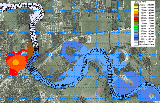 For more than a decade, MIKE FLOOD has offered complex and flexible features for coupling 1D and 2D hydrodynamic models. Flood extents and flood hazards have been some of the key issues for flood modelling. These issues will continue to be of great importance and still be focus points for many modelling applications in the future, but in addition to this, the new release of MIKE FLOOD now offers the option to simulate the transport and spreading of pollutants during a flood event through a fully dynamic coupling of the Advection Dispersion modules of MIKE 11, MIKE 21, and MIKE URBAN.
The new AD-coupling in MIKE FLOOD enables users to simulate new interesting aspects such as: -
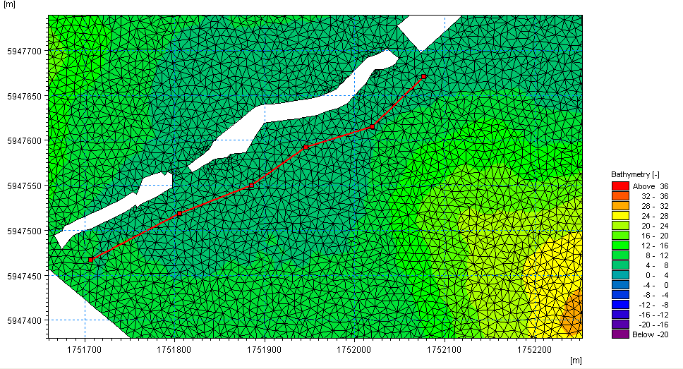 A new dike structure option has been implemented in the Flexible Mesh series of MIKE 21 and MIKE 3. Dike structures are defined by structure specific data parameters as well as location and geometry. The location in the horizontal domain is given by two or more geo-reference points (a polyline), which defines the width of the structure perpendicular to the flow direction. Each point in the polyline should be given a crest level, and it is therefore possible to obtain a spatial variation of crest elevations along a dike structure within the model domain.
Dike structures are generally used to describe local flow obstructions or other special topographical features, which are not included in the model bathymetry, and as such a highly useful feature for both coastal and inland applications. The discharge over a section covered by the dike is calculated using a standard weir expression.
MIKE SHE: Frozen soil
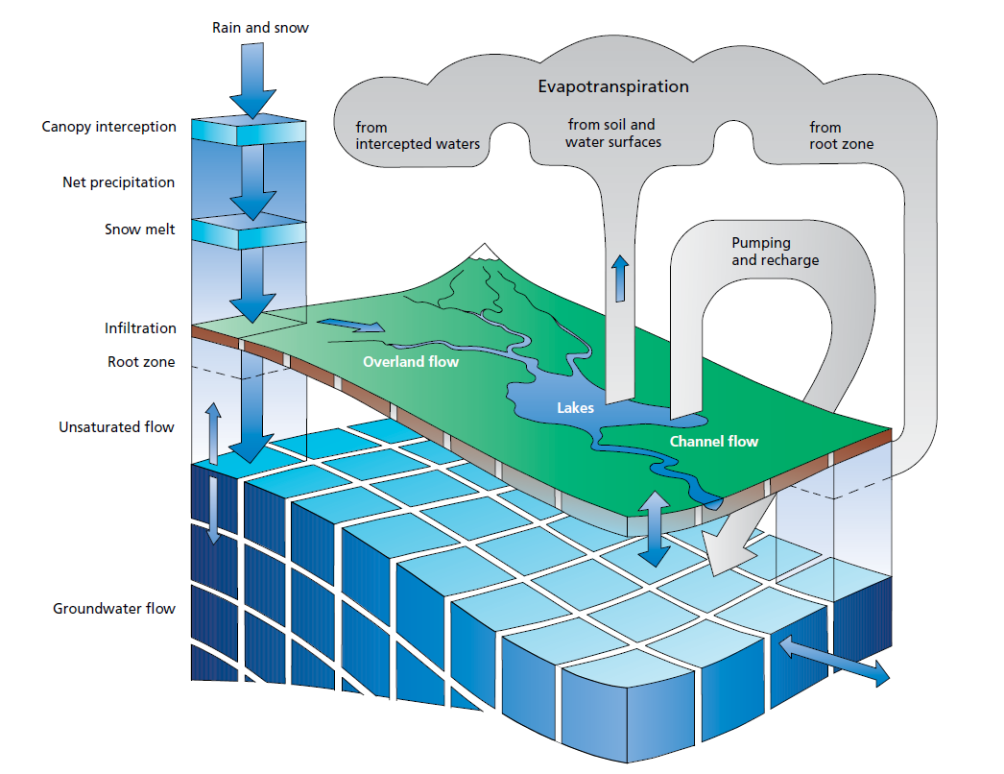 The 2012 release of MIKE SHE will contain a range of new improvements. Among these are the improvements in simulation of the annual variation of soil infiltration capacity due to freezing and thawing dynamics.
A simplified approach has been implemented, which allows the user to define a time-varying OL-UZ (Overland to Unsaturated Zone) leakage coefficient, and thereby enables the user to control the balance between infiltration and direct runoff from precipitation during all seasons of the year.
.
We are gradually approaching the release of the MIKE by DHI software package 2012, which is scheduled for this October. As in previous issues of our newsletter, we would like to disclose a preview of the many new and exciting features, which we hope will improve your experience when using the software products, both with regard to usability, productivity, and enhanced applications.
MIKE FLOOD AD: fully dynamic AD-coupling
Release 2012 introduces a fully dynamic AD-coupling in MIKE FLOOD, which increases the range of applications substantially.
The new AD-coupling in MIKE FLOOD enables users to simulate new interesting aspects such as: -
- floodplain contamination from polluted rivers
- impact assessment on river quality from pollutant sources in flood prone areas during flood events
- the impact on concentrations of river pollutant in case of a release from an urban Combined Sewer Overflow
Dike structures are generally used to describe local flow obstructions or other special topographical features, which are not included in the model bathymetry, and as such a highly useful feature for both coastal and inland applications. The discharge over a section covered by the dike is calculated using a standard weir expression.
MIKE SHE: Frozen soil
A simplified approach has been implemented, which allows the user to define a time-varying OL-UZ (Overland to Unsaturated Zone) leakage coefficient, and thereby enables the user to control the balance between infiltration and direct runoff from precipitation during all seasons of the year.
.
Tuesday, 7 August 2012
Integrated Surface and Groundwater Model Review and Technical Guide
 The Ontario Ministry of Natural Resources has published a guideline report evaluating the applicability of integrated surface and groundwater hydrologic models including MIKE SHE, GSFLOW, and HYDROGEOSPHERE. While tailored to Ontario watersheds, UK users of MIKE SHE may find the report of interest.
"While integrated models are able to provide a more complete representation of hydrologic processes, they have not yet seen widespread application within Ontario. To address this knowledge gap, the Ontario Ministry of Natural Resources initiated a study to determine the applicability of integrated hydrologic models to Ontario watersheds. The report includes: a qualitative comparison of several integrated model codes; the application of multiple integrated model codes to two case-study watersheds; and guidance to water resource practitioners on how to develop and calibrate an integrated model." from WaterBudget.ca (2011)
.
"While integrated models are able to provide a more complete representation of hydrologic processes, they have not yet seen widespread application within Ontario. To address this knowledge gap, the Ontario Ministry of Natural Resources initiated a study to determine the applicability of integrated hydrologic models to Ontario watersheds. The report includes: a qualitative comparison of several integrated model codes; the application of multiple integrated model codes to two case-study watersheds; and guidance to water resource practitioners on how to develop and calibrate an integrated model." from WaterBudget.ca (2011)
.
Saturday, 7 July 2012
Catchment Management
On the 20th June ESI Ltd held their annual water industry seminar in Reading which helped celebrate the opening of their new South East regional office. This year’s conference focussed on the benefits and implications of the rapidly evolving field of catchment management.
ESI have uploaded most of the presentations to their website – here – and DHI's contribution is presented below.
Many thanks to Torsten Jacobsen for permission to use this presentation.
.
On the 20th June ESI Ltd held their annual water industry seminar in Reading which helped celebrate the opening of their new South East regional office. This year’s conference focussed on the benefits and implications of the rapidly evolving field of catchment management.
ESI have uploaded most of the presentations to their website – here – and DHI's contribution is presented below.
Many thanks to Torsten Jacobsen for permission to use this presentation.
.
Sunday, 23 October 2011
Comprehensive Overview of MIKE SHE
Comprehensive overview of MIKE SHE by Douglas Graham (Oct 2011).
MIKE SHE Questions & Answers
MIKE SHE questions and answers; an interview with Douglas Graham (Oct 2011).
For more videos / animations please visit the DHI Group, MIKE by DHI and FEFLOW YouTube channels: -
Comprehensive overview of MIKE SHE by Douglas Graham (Oct 2011).
MIKE SHE Questions & Answers
MIKE SHE questions and answers; an interview with Douglas Graham (Oct 2011).
For more videos / animations please visit the DHI Group, MIKE by DHI and FEFLOW YouTube channels: -
- http://www.youtube.com/user/DHIGroup
- http://www.youtube.com/user/MIKEbyDHI
- http://www.youtube.com/user/FEFLOWbyDHI
.
Friday, 31 December 2010
Water Resources
Developments in Release 2011 common to all Water Resources Packages:
MIKE FLOOD
In a recent independent review carried out for the UK Environment Agency, MIKE FLOOD received the highest marks - not only for speed but also for model setup, runtime, stability, presentation and visualisation of results, sensitivity tests and file management. MIKE FLOOD achieved the highest overall score in the study. In Release 2011, there are further improvements in both speed and usability.
User interface

New linkage features
MIKE 11
MIKE 1D is a re-engineering project of MOUSE and MIKE 11 simulation engines. The outcome is one common engine for both products. A subset of the complete functionality will be available with the 2011 Release and will ensure faster simulations, 64-bit combability, parallel processing and enhanced interfacing of coupled river-urban simulations.
Client requested MIKE 11 enhancements:
MIKE SHE
Complex water quality modelling of multispecies, kinetic reactions is now available in MIKE SHE using ECO Lab. ECO Lab opens a whole range of new opportunities for comprehensive and flexible water quality and ecohydrology modelling in the overland flow, unsaturated zone and groundwater.
Further, MIKE SHE can now use a fine scale DEM for detailed flooding without seriously impacting runtime.
MIKE BASIN
The irrigation functionality of MIKE BASIN has been extended with alternative runoff and soil water options in Release 2011.
Furthermore, MIKE BASIN has been extended for simulation of crop water requirements and crop yield for rice.
FEFLOW
The HD-coupling between FEFLOW and MIKE 11 have been present for years. With the 2011 Release it is now being supplemented with AD-Coupling for simultaneous HD+AD simulations.
.
Developments in Release 2011 common to all Water Resources Packages:
- Climate change functionality
- Parallelisation
- 64-bit applications
- Autocalibration for multicore PCs
MIKE FLOOD
In a recent independent review carried out for the UK Environment Agency, MIKE FLOOD received the highest marks - not only for speed but also for model setup, runtime, stability, presentation and visualisation of results, sensitivity tests and file management. MIKE FLOOD achieved the highest overall score in the study. In Release 2011, there are further improvements in both speed and usability.
User interface
- Reorganised ‘Links Definition’ page which enables an enlarged map view
- Direct access to bathymetry and cross-sections from the map view
- Displaying cross-sections in the map view
- New main menu dialogues for Setting default values of new links and Global change of parameters for links

New linkage features
- New link option - MIKE 11 side structures linked to MIKE 21
- Time dependent levee levels
- Automatic splitting of lateral links into a user-defined number of shorter segments
MIKE 11
MIKE 1D is a re-engineering project of MOUSE and MIKE 11 simulation engines. The outcome is one common engine for both products. A subset of the complete functionality will be available with the 2011 Release and will ensure faster simulations, 64-bit combability, parallel processing and enhanced interfacing of coupled river-urban simulations.
Client requested MIKE 11 enhancements:
- Cross-section editor; automatic update of markers at levees
- Improved copy & paste capabilities
- Additional level in grid points dialogue (Network Editor)
- Executable for batch calculation of Structures Qh relations
MIKE SHE
Complex water quality modelling of multispecies, kinetic reactions is now available in MIKE SHE using ECO Lab. ECO Lab opens a whole range of new opportunities for comprehensive and flexible water quality and ecohydrology modelling in the overland flow, unsaturated zone and groundwater.
Further, MIKE SHE can now use a fine scale DEM for detailed flooding without seriously impacting runtime.
MIKE BASIN
The irrigation functionality of MIKE BASIN has been extended with alternative runoff and soil water options in Release 2011.
Furthermore, MIKE BASIN has been extended for simulation of crop water requirements and crop yield for rice.
FEFLOW
The HD-coupling between FEFLOW and MIKE 11 have been present for years. With the 2011 Release it is now being supplemented with AD-Coupling for simultaneous HD+AD simulations.
.
Subscribe to:
Posts
(Atom)
Follow DHI...


